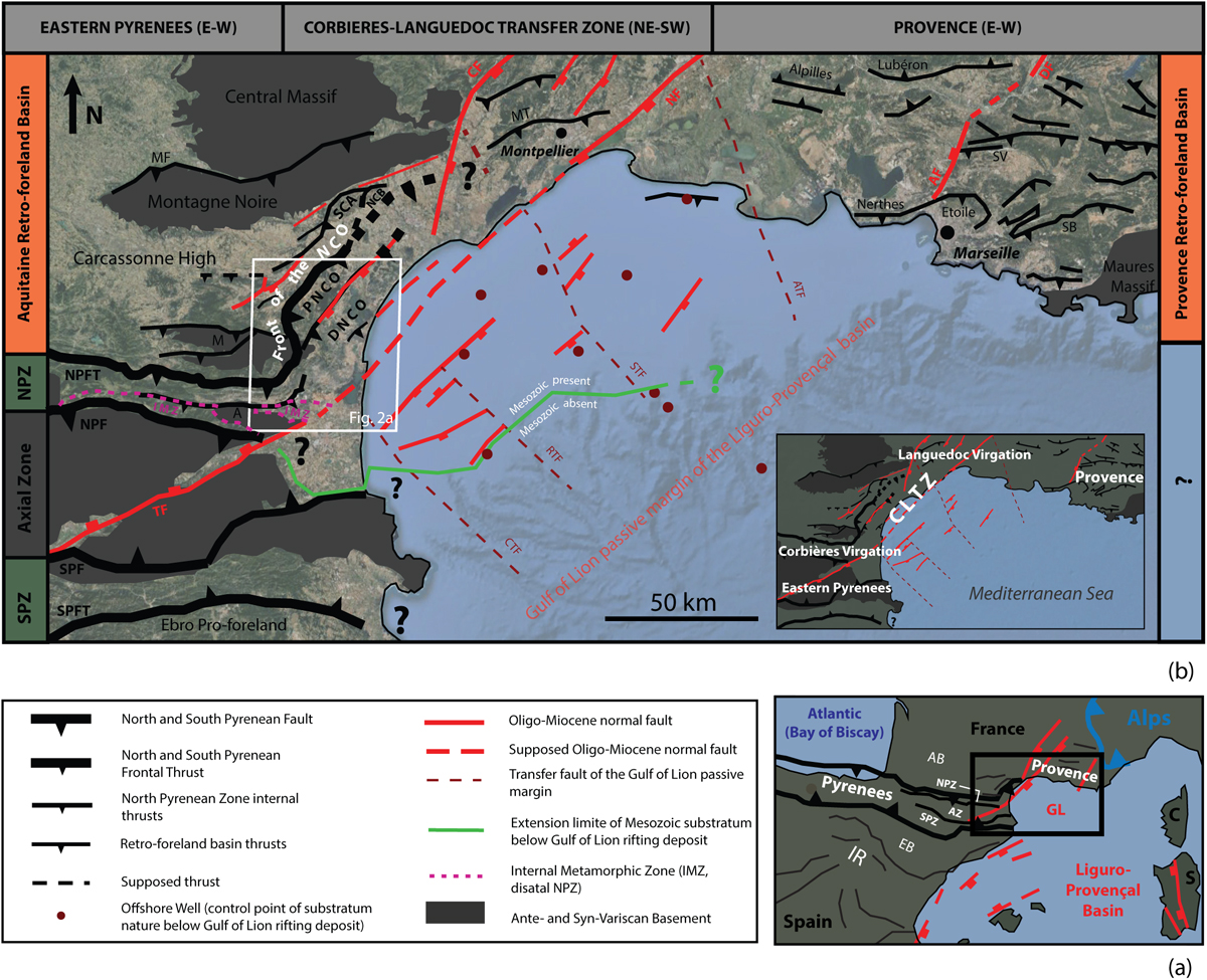
Fig. 1

Download original image
(a) Simplified map of the Pyrenean-Provençal orogen and Gulf of Lion margin showing the location of the map in b. Abbreviations are C: Corsica; S: Sardinia; GL: Gulf of Lion; AB: Aquitaine Basin; NPZ: North Pyrenean Zone; SPZ: South Pyrenean Zone; EB: Ebro Basin; IR: Iberian Range. (b) Structural map of the Eastern Pyrenees − Provence linkage zone (Corbières-Languedoc Transfer Zone), showing the main orogenic domains and features as well as Oligo-Miocene extensional features. Locations of Figure 2 are boxed in white. At the bottom right is a simplified sketch of the map in b showing main regional domaines in white. Abbreviations are CLTZ: Corbières-Languedoc Transfer Zone; NPFT: North Pyrenean Frontal Thrust; NPF: North Pyrenean Fault; SPF: South Pyrenean Fault; SPTF: South Pyrenean Frontal Thrust; NCO: Nappe des Corbières Orientales; PNCO: Proximal Nappe des Corbières Orientales; DNCO: Distal Nappe des Corbières Orientales; SCA: Saint-Chinian Arc; NCB: Nappe de Cazoul-les-Béziers; MF: Mazamet Fault; MT: Montpellier Thrust; TF: Têt Fault; NF: Nîmes Fault; CF: Cevennes Fault; AF: Aix-en-Provence Fault; DF: Durance Fault; CTF: Catalan Transfer Fault; RTF: Rascasse Transfer Fault; STF: Sète Transfer Fault; ATF: Arles Transfer Fault; M: Mouthoumet massif; A: Agly Massif; SV: Sainte Victoire; SB: Sainte Baume.
Current usage metrics show cumulative count of Article Views (full-text article views including HTML views, PDF and ePub downloads, according to the available data) and Abstracts Views on Vision4Press platform.
Data correspond to usage on the plateform after 2015. The current usage metrics is available 48-96 hours after online publication and is updated daily on week days.
Initial download of the metrics may take a while.


