")
")
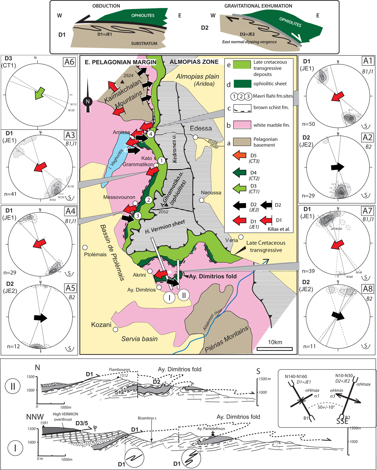
Fig. 5
Download original image
(A) Geological sketch of the Eastern margin of the Pelagonian zone between the Kajmackchalan and Pierias Mts. Large red arrows: vergence of the ophiolitic sheet during the obduction (D1 event), large black arrows: top-to-the-E vergence of the ophiolites during the exhumation event (D2 event). The stereonets give: fold axes (B) and lineations (l) on equal area projection, lower hemisphere; n: number of data, B1, B2..: successive fold families at the analyzed sites, pt.1, 2, and 3: locations of the Mavro Raki formation. Sites, A1, 2: Arnissa, A3: Grammatikos, A4, 5: Messovouno, A6: East Pelagonian, A7, 8: Agios Dimitrios. Section I: kilometric scale folds near Ayios Dimitrios (Kozani geol. sheet, Anastopoulos et al., 1980) formed below the ophiolitic sheet, it indicates a top-to-the-WSW vergence (D1 event) followed by an eastern vergence (D2 event) (Section II) (after Vergély, 1984) (see text). At the top of the Fig. 5A, cartoons show the top-to-the-W. folding below thrusting of the ophiolitic nappe and top-to the E. folding of the substratum of ophiolite nappe during the exhumation. (B) Geological sketch of the Vourinos area and schematic cross section of the Vourinos ophiolitic sheet. Sites B1, B2 are situated 5 km N of Khromion village and B3, B4 along the Aliakmon River bank; same symbols as on Figure 5A.
Current usage metrics show cumulative count of Article Views (full-text article views including HTML views, PDF and ePub downloads, according to the available data) and Abstracts Views on Vision4Press platform.
Data correspond to usage on the plateform after 2015. The current usage metrics is available 48-96 hours after online publication and is updated daily on week days.
Initial download of the metrics may take a while.