")
")
| Issue |
BSGF - Earth Sci. Bull.
Volume 196, 2025
Recent evolution of the Mediterranean realm: Exploring the links between deep and shallow processes in a plate convergent setting
|
|
|---|---|---|
| Article Number | 14 | |
| Number of page(s) | 25 | |
| DOI | https://doi.org/10.1051/bsgf/2025010 | |
| Published online | 08 August 2025 | |
The Cenozoic basins of Sardinia (Italy) and their Late Miocene to Present inversion: insight from new seismic data
Les bassins cénozoïques de Sardaigne (Italie) et leur inversion Miocène supérieur à l’Actuel : Apport de nouvelles données sismiques.
1
Saras Spa., Galleria Passarella 2, Milan, Italy
2
Geologist, consultant, Cagliari, Italy
3
Cagliari University, Sardinia, Italy
4
Beicip-Franlab, 232, Av. Napoléon Bonaparte, 92502 Rueil-Malmaison, France
* Corresponding author: This email address is being protected from spambots. You need JavaScript enabled to view it.
Received:
3
July
2024
Accepted:
2
April
2025
Abstract
This study aims to discuss the history and significance of the Cenozoic basins in Sardinia, both before and after the rotation of the Corsica-Sardinia Block, within the Western Mediterranean geodynamic framework, taking into account new seismic data. A grid of 2D seismic profiles with better penetration, improved processing, and calibration by 2 wells (Oristano-1 and Campidano-1) brought novel findings. Two tectonic phases, pre-rotation of the Corsica-Sardinia Block, are now recognized: Phase 1 previously unknown, resulted in the formation of a narrow (20 km) half graben infilled by 3 to 4 km thick syntectonic continental sediments. By comparison with the Paleogene basins of S France, its formation could have started in the Late Eocene. It could include: 1-the syntectonic continental Chattian Ussana Formation of Sardinia, whose base corresponds to the onset in Latest Rupelian-Earliest Chattian time of the calc-alkaline volcanics crossing Sardinia 2-possibly also below part or unknown time equivalent of the post-Pyrenean tectonics Middle-Upper Lutetian to Late Rupelian fluvial-lacustrine Cixerri Formation. Phase 2 resulted in the formation above it, of the wider (more than 50 km) Sardinia Graben System (SGS) more than 200 km long, crossing entire Sardinia from S to N. It is characterized by the deposition of 2 to 3 km thick sediments, continental, deltaic to deep marine in the axis, from the Latest Chattian to the Early Burdigalian. The SGS infilling is like the series deposited in the grabens onshore Southern France and on the margin of the Gulf of Lion. Since the Late Chattian a transgression of the sea from the south became possible in the SGS and the Ligurian-Provençal rift, through deep corridors created between Sardinia and the Balearic Islands. The characteristics of the SGS, its easternmost location in the western Mediterranean extensional system, its boundaries to the north and south linked respectively to the termination of the Provençal and Catalan-North Balearic transfer-transform fault systems, are in favor of the SGS being a failed arm of the W Mediterranean Rift System. Formed after the rotation of the Corsica Sardinia Block, the narrow (20 km) Campidano Graben is now interpreted as a transpressional basin, of Late Miocene (Tortonian) to Recent age. It is superimposed on the western part of the SGS and on the deeper Oligocene half-graben. Its boundaries are major faults of the SGS, reactivated as strike-slip faults with an inversion of the basin sediments of more than 1000 m on its eastern side. It allows interpreting the Campidano basin as a transpressional basin resulting from a regional N-S oriented compressional stress on the pre-existing SGS. It agrees with the generalized inversion of the Neogene basins since the Late Miocene in the western Mediterranean due to the Africa-Eurasia convergence.
Résumé
Le but de cette étude est de discuter sur la base de nouvelles données sismiques, la nature et la signification, dans le cadre géodynamique de la Méditerranée occidentale, des bassins cénozoïques de Sardaigne formés avant et après la rotation du Bloc corso-sarde au Miocène. Un maillage de profils sismiques 2D avec une meilleure pénétration, un traitement amélioré et une calibration par 2 forages (Oristano-1 et Campidano-1) a apporté des connaissances nouvelles. Deux phases tectoniques précédant la rotation du Bloc corso-sarde ont été reconnues. La phase 1 s’est traduite par la formation d’un demi-graben étroit mais profond, inconnu jusqu’alors, suggérant une composante en cisaillement de la faille bordière. 3 à 4 km de sédiments syntectoniques s’y sont déposés. Par comparaison avec les bassins paléogènes du Sud de la France, la base pourrait être Eocène moyen. Les dépôts syntectoniques incluraient 1-la Formation continentale syn-tectonique d’Ussana d’âge Chattien dont la base correspond au début du volcanisme calco-alcalin Rupélien terminal-Chattien basal lié à l’arc volcanique traversant la Sardaigne. 2- Une partie ou un équivalent non connu de la Formation fluvio-lacustre post tectonique pyrénéenne de Cixerri d’âge Lutétien moyen-supérieur à Rupélien terminal. La Phase 2 s’est traduite par la formation au-dessus, du Système de Grabens de Sardaigne, large de plus de 50 km, traversant la Sardaigne du Sud au Nord sur plus de 200 km. 2 à 3 km de sédiments syn-rift s’y sont déposés du Chattien terminal-Aquitanien au Burdigalien Inférieur dans des environnements continentaux à deltaïques devenant marins profonds dans l’axe du graben. Ces séries sont similaires à celles des bassins du même âge du S de la France et du Golfe du Lion. Depuis le Chattien terminal, une transgression marine du S au N a été rendue possible par l’ouverture de corridors en Sardaigne et entre la Sardaigne et les Baléares. Les caractéristiques de ce graben, sa position à l’Est du système de rift back-arc de Méditerranée occidentale, ses limites N et S liées respectivement à la terminaison des grandes failles de transfert de Provence et nord Baléares suggèrent que le Graben sarde constitue un bras avorté du système de rift W méditerranéen. Superposé aux grabens Oligocène et Miocène inférieur, l’étroit (20-30 km) Graben du Campidano, postérieur à la rotation du Bloc corso-sarde, est interprété comme un bassin en transpression d’âge Miocène supérieur (Tortonien) à Récent. Ses bordures sont des failles majeures du Graben sarde, réactivées en failles de cisaillement avec une inversion de plus de 1000 m de la partie orientale du bassin. Il résulte d’une contrainte régionale N-S sur la structure antérieure Oligo-Miocène, en accord avec l’inversion généralisée des bassins néogènes de Méditerranée occidentale due à la convergence Afrique-Eurasie depuis le Miocène terminal.
Key words: NW Mediterranean / Sardinia / Cenozoic basins / seismic reflection / tectonic inversion
Mots clés : NO Méditerranée / Sardaigne / bassins cénozoïques / sismique réflexion / inversion tectonique
© C. Allevi et al., Published by EDP Sciences 2025
 This is an Open Access article distributed under the terms of the Creative Commons Attribution License (https://creativecommons.org/licenses/by/4.0), which permits unrestricted use, distribution, and reproduction in any medium, provided the original work is properly cited.
1 Introduction
1.1 Background
Sardinia, part of the Corsica-Sardinia continental Block detached from Iberia-Europe (Fig. 1) during the formation of the Ligurian-Provençal back-arc Basin, offers the opportunity to study basins linked to the Oligocene and Miocene tectonic events preceding the Basin formation, as well as their Late Miocene to Recent inversion due to the convergence of Africa and Europe. These basins include the Latest Oligocene to Early Burdigalian Sardinian Graben System (SGS) and the superimposed Pliocene-Quaternary Campidano Graben (Fig. 2A). While excellent outcrops have allowed detailed studies of the surface geology, depicting the graben’s deep structure and their infilling relies on seismic reflection data and deep boreholes. Based on sparse old 2D seismic data and field studies, a first interpretation of the SGS was proposed by Casula et al. (2001). From 2006 to 2010, Saras Spa acquired 655 km of new 2D seismic profiles in two areas of the Campidano Graben, in the central and southern parts of the SGS. A grid of about 2 km spacing, better penetration, improved processing, and stratigraphic calibration by two deep wells, Oristano-1 (SAIS, 1961) and Campidano-1 (SAIS, 1964), brought new insights into the geology of the SGS and the Campidano Graben.
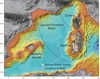 |
Fig. 1 Sardinia in the western Mediterranean realm. Morpho-bathymetric map from CCGM-CGMW (Paris December 2010) with 1: the Oligo-Miocene Sardinia Graben System (SGS) and 2: the Campidano Graben. Circles illustrating the rotation of the Corsica-Sardinia Block (CSB) do not represent the probable multi-stages motion of the CSB. |
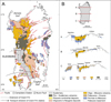 |
Fig. 2 A. Schematic geological map of the Sardinia Oligo-Miocene Graben (SGS) and of the superimposed Late Miocene to Recent Campidano Graben (Cherchi and Montadert, 1982) with the location of the two Saras Spa surveys (Eleonora and Igia) on the Campidano Graben. Area of deposition of the Cixerri Fm (Middle Lutetian to Late Chattian) is indicated with sediments transport direction. B. Schematic cross sections through the SGS (Cherchi, 1985). Sediments thickness is very underestimated in the grabens. Morphology shows that the area of extension is wider than the area where syn-rift sediments are preserved. Surveys are located on the Campidano Graben (sections B and C) about 20 km wide superimposed on the SGS about 100 km wide. |
1.2 Objectives of the study
The purpose of the present study is to propose an updated geological history of the SGS with new evidence of an older deep half graben below, a new interpretation of the Late Miocene to Recent Campidano Graben superimposed on the SGS, and to discuss their significance within the framework of the western Mediterranean geodynamic history.
2 Geological setting
2.1 General framework
Within the Mediterranean geodynamic framework (Figs. 1 and 2A), the nature and significance of the Oligo-Miocene Graben System of Sardinia (SGS) and the origin of the Campidano Graben remain subjects of discussion. Already observed by Vardabasso (Fossa Sarda, 1952), the SGS was recognized (Barberi and Cherchi, 1980; Cherchi and Montadert, 1982; 1984) as a favourable site to obtain geological information applicable to the NW Mediterranean Basin during its rifting period. Indeed, outcrops make it possible to describe and date a large part of the sedimentary succession infilling the SGS. In a synthesis of geological data from field studies and sparse seismic data acquired from 1960 to 1992, Casula et al. (2001; 2015) proposed a scenario for its formation and evolution. Cherchi et al. (2008) established a detailed chronology of the tectonic events and of the sedimentary formations. It was shown that the SGS forms a single tectonic unit stretching from the Gulf of Asinara in the North to the Gulf of Cagliari in the South (Fig. 2A). This structural continuity on a heterogeneous Basement, visible on three schematic EW cross sections of Sardinia (Fig. 2B), does not imply all along, a homogeneous sedimentary infilling (Casula et al., 2001). For example, the continuity of the deep marine Miocene sediments is interrupted in the central part of the SGS buried below Oligocene-Miocene calc-alkaline volcanics and Pliocene-Quaternary Volcanics at the level of the Nuoro Fault (Fig. 2A) (Elter et al., 1990). North of it, the absence of seismic data did not allow imaging the deep structure. However, the marine Lower Miocene sediments indicate shallower water conditions becoming deep again in the northern termination of the SGS in the Asinara Gulf.
Following these studies, the SGS was formed by rifting from the Latest Oligocene to the Early Burdigalian like the grabens in the Gulf of Lion margin (Gorini, 1993; Gorini et al., 1993, 1994) with the same SE-NW orientation before the rotation of the CSB. The syn-rift sediments were deposited in a marine environment since the Late Chattian, with rapid lateral transition to continental syn-tectonic alluvial fans: the Ussana Formation (Fm) (Pecorini and Pomesano Cherchi, 1969). At that time, sparse 2D vintage seismic data did not allow to image correctly the subsurface below the Miocene sediments. Field structural analysis showed that western Sardinia was affected by the Pyrenean shortening event and by a Middle Miocene N 40° shortening event which could correspond to the end of the rotation of the Corsica-Sardinia Block (CSB) (Letouzey et al., 1982; Trémolières et al., 1984; Cherchi and Trémolières, 1984). A complete change occurred in the Latest Miocene with a shortening event oriented N140° (Cherchi and Trémolières, 1984).
However, there is still a debate concerning the complex Cenozoic structural history of Sardinia, which was affected by the Pyrenean tectonics, the formation of the Oligo-Miocene Ligurian-Provençal basin, the Apenninic tectonics and the formation of the Tyrrhenian Sea. Discussions concerned the age (Eocene, Miocene or Eocene reactivated in the Miocene) and origin of the west vergent thrust belt of eastern Sardinia, and consequently the age and significance of the Oligo-Miocene Graben System of Sardinia in the overall evolution of the Western Mediterranean (Chabrier, 1970; Chabrier et Mascle, 1984; Carmignani et al., 1992; Carmignani et al., 1994; Carmignani et al., 1995; Pasci et al., 1998; Carmignani et al., 2001; Faccenna et al., 2002; Carmignani et al., 2004; Sau et al., 2005; Oggiano and Funedda, 2007; Dieni et al., 2008; Zattin et al., 2008; Oggiano et al., 2009; Arragoni et al., 2016). For example, one point of view considered that there was no extension leading to an NE-SW trending rift active in Sardinia during Late Oligocene-Aquitanian times before the rotation of the CSB. In that case, the so-called Sardinia rift would be an assemblage of shallow asymmetric basins, trending N 150° that developed during the Late Burdigalian − Langhian, i.e., at the same time as the rotation of Sardinia and the onset of the collapse of the North Apennine and Alpine Corsica orogenic wedge and the opening of the Tyrrhenian Sea.
In the central and southern part of the SGS (Fig. 2A), the narrow Campidano Graben, essentially covered in surface by Quaternary sediments, was studied by field observation, potential geophysical methods and interpretation of vintage seismic data. (Pecorini and Pomesano Cherchi, 1969; Cherchi et al., 1978; Marini and Murru, 1983; Ciminale et al., 1985; Balia et al., 1991a; Balia et al., 1991b; Casula et al., 2001). It was interpreted as a Pliocene-Quaternary graben, superimposed on the western side of the SGS (Fig. 2A). Its formation was in general, considered as linked to the formation of the Tyrrhenian Sea back-arc basin.
2.2 Pre-rift geological background
The pre-rift geological background of the SGS is reviewed in this study for comparison of Sardinia with Europe and Iberia. We will particularly investigate the record of the transition from the Pyrenean shortening to the Ligurian-Provençal rifting as it is observed on the outcrops but also imaged now by the new seismic data.
2.2.1 Variscan basement and Mesozoic sediments
On the complex Variscan Basement of western Sardinia above iron-rich paleosoils (“Ferro dei Tacchi”, Vardabasso, 1959), Mesozoic sediments outcrop, showing sensible differences on the western and eastern sides of the SGS. In the northwestern side, the Mesozoic sequence starts with a thick Permo-Triassic succession overlapped by Jurassic and Cretaceous neritic carbonates (Cherchi et al., 2010). In the southwestern side, the Mesozoic series are very similar. They are comparable to those outcropping in the Pyrenees-Provence area (southern France) (Chabrier & Mascle, 1975). On the eastern side, the Mesozoic is represented by isolated Triassic carbonates and Middle Jurassic carbonates resting on the Triassic locally or directly on the Basement. Only in the easternmost side of Sardinia, the Mesozoic develops again towards the Mesozoic Ligurian oceanic basin.
The Mesozoic was deformed during the Middle-Late Cretaceous and the Eocene due to the Africa-Eurasia convergence as observed around the Mediterranean.
2.2.2 Mid-Eocene Pyrenean shortening event
The Mid-Eocene “Pyrenean” shortening event has been recognized in the whole western Sardinia (Chabrier, 1970; Chabrier et al., 1984; Letouzey et al., 1982; Cherchi and Trémolières, 1984; Trémolières et al., 1984; Pomesano Cherchi, 1963). It was important in SW Sardinia with reverse faults and overthrusts (Barca & Costamagna, 1997; 2000). They are active at least until the base of Lutetian (Agus and Pecorini, 1978; Pittau Demellia, 1979; Salvadori, 1980; Pecorini, 1963; Raponi, 2003; Matteucci, 1985; Murru and Matteucci, 2002), while deformations continued until Middle Lutetian in Eastern Sardinia. Eocene sediments rest directly on the Basement or on Mesozoic sediments of different age depending on the location. The marine transgression came from E-NE to SE of Sardinia (in present position) where marine Montian and Paleocene is known (Dieni et al., 1979). In SW Sardinia, the succession starts with shallow marine limestones dated Thanetian and Early Ypresian (Early Middle Ilerdian) (Cherchi, 1983). Above, the sequence become paralic with coal seams of Late Ypresian age intercalated (Pittau, 1977; Salvadori, 1980; Fanni. et al., 1982; Cappetta and Thaler, 1973). The paralic sequence disappears to the East nearby the western edge of the Campidano Graben but thickens to the west until the coastline.
2.2.3 Post-tectonic Cixerri formation
Above, the post-Pyrenean tectonics Cixerri Fm restricted to SW Sardinia (Fig. 2A), with 100 to 400 m thick continental fluviatile-lacustrine sediments, is unconformable on the lignitiferous paralic Eocene (Late Ypresian) basin sediments deformed by the Pyrenean Orogeny or on the Variscan Basement (Pecorini and Pomesano Cherchi, 1969; Barca and Palmerini, 1973; Barca and Digregorio, 1977; Cherchi and Montadert, 1982; Barca and Costamagna, 1997, 2000, 2010; Costamagna and Schäfer, 2018). Its base is dated Middle Lutetian by Charophyta and palynomorphs (Agus and Pecorini, 1977; Pittau Demelia, 1979; Salvadori, 1980). Sediments were deposited in a NW to SE transport direction and are crosscut by the SGS. At their base, they contained pebbles of metamorphic rocks and of Middle Cretaceous limestones bearing microfauna characteristic of the Pyrenean-Provence domain (Cherchi and Schroeder, 1976; Cherchi, 1979). It shows that the Cixerri Fm resulted from the erosion of Pyrenean reliefs located NW of Sardinia. Equivalent deposits have also been found in the Balearic Islands (Bourrouilh, 1973, 1976; Colom, 1976). The Cixerri Fm is covered by the continental syntectonic conglomeratic Ussana Fm (Peccorini and Pomesano Cherchi, 1969) or by the equivalent Flumentepido Fm (Barca and Costamagna, 2010) with calc-alkaline volcanics pebbles, or directly by calc-alkaline volcanics. This calc-alkaline volcanism is dated 32 to 13 My in Sardinia (Beccaluva et al., 1985). Its onset in SW Sardinia is dated 29.9 to 27.5 My and 24.9 to 26 My (Funedda et al., 2009) thus consistently late Rupelian to early Chattian in age. Therefore, the post-tectonic Cixerri Fm represents Pyrenean originated continental, molassic sediments deposited before the formation of the SGS. It should exist at great depth below the SGS (Raponi, 2003). Indeed, it outcrops again to the SE with indication of marine influences dated Oligocene below Late Rupelian-Early Chattian andesites (Pecorini and Pomesano Cherchi, 1969) and above marine Eocene (Lower Ypresian) carbonates.
2.2.4 Syntectonic Ussana formation
The syntectonic clastic Ussana Fm above, corresponds to an important structural change with creation of new reliefs and escarpments and strong erosion. Typically, continental breccias, and heterometric conglomerates embedded in a red-violine clayey matrix were deposited as slope deposits, alluvial fans or torrential deposits. This change was interpreted as the beginning of the W Mediterranean back arc rifting phase in a continental environment, dated around 30 My by the volcanics i.e., Middle Oligocene (Latest Rupelian-Early Chattian) (Cherchi and Montadert, 1982). There is a gap in the field observations in Sardinia between the base of the Ussana Fm and its top below the marine deposits of latest Chattian-Aquitanian age in the SGS. However, the new seismic data available show a several km thick syn-tectonic sedimentary section below the SGS. Its nature and age will be further discussed with comparison with the Paleogene basins of the same age in southern France (Semmani et al., 2023; 2024).
3 Data and methodology
3.1 Biostratigraphy
Biostratigraphy is particularly important in a rifting context such as the SGS, as sedimentary environments and thicknesses are strongly influenced by syn-sedimentary faulting, resulting in a wide range of facies from continental to shallow and deep marine environments. Oligo-Miocene calc-alkalic volcanism (Savelli et al., 1979) and Plio-Quaternary volcanics (Beccaluva et al., 1977, 1985) also have an important influence on the sedimentation. This complex relationship has been clarified along the eastern panel of the SGS because its eastern faulted boundary is well preserved while its western boundary was reactivated during the formation of the Plio-Quaternary Campidano Graben.
The clarification was the result of continuous detailed geological mapping of outcrops and interpretation of vintage seismic profiles (Casula et al., 2001; Longhitano et al., 2015). The chrono-biostratigraphic data provided the basis for establishing the sedimentary successions on outcrops (Cherchi et al., 2008) but also in two wells drilled in the deeper part of the graben, Oristano-1 and Campidano-1 (Pecorini and Pomesano Cherchi, 1969; Pomesano Cherchi, 1971), where cuttings, long and side-wall cores were available. The zonations used is based on the planktonic foraminifera zonation proposed by Mancin et al. (2003, 2007) and calcareous nannofossils zonation of Fornaciari and Rio (1996) for the Miocene.
3.2 Seismic data
The first 2D seismic data (593 km) in S Sardinia were acquired by Wintershall during the early 1960’s and resulted by drilling the Oristano-1, Oristano-2, and Campidano-1 wells by SAIS. The second 2D survey was carried out by AGIP in the early 1990’s with acquisition of 285 km-line. These older profiles were interpreted and integrated with the field studies in Casula et al. (2001). The third survey used in this study, was realized by Saras SpA in 2006 and 2010. Contrary to the previous surveys, the 2D profiles (655km) were acquired on 2 areas only in the Campidano Graben but with a regular grid of few km spacing (Figs. 3–5). On one N-S line in the Oristano area, acquisition parameters were modified resulting in a much deeper penetration. It allowed imaging an unknown older thick half graben. After processing (in Time), interpretation (in Time) was carried out with a calibration based on the Oristano-1 and Campidano-1 wells whose biostratigraphy, well logs and especially the velocities have been reassessed. Time mapping was realized on major markers. Finally, depth mapping was created through average velocity maps based on seismic velocities with control from known depths at wells of remarkable seismic markers as the Pliocene basalts flows and the Messinian Erosional Surface (MES).
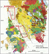 |
Fig. 3 The Central and Southern Sardinia Oligo-Miocene Graben System on the Sardinia Geological Map with the 2 Saras Spa surveys located in the Campidano Graben with the OR-1 and Campidano − 1 wells. |
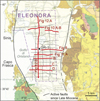 |
Fig. 4 The Saras Spa Eleonora survey (North Campidano) on the Geological Map of Sardinia with location of the new seismic lines and of the Oristano-1 (OR-1) well. Profiles presented in the publication are in red. |
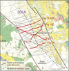 |
Fig. 5 Location of the Saras Spa seismic survey in the Central-South Campidano on the Geological Map of Sardinia with the Oristano-1 well. Profiles presented in the publication are in red. Note the basin inversion on the E side of the Campidano. |
3.3 Potential methods
The study area and the location of the two surveys by Saras SpA are shown on the Bouguer anomaly map and its first order vertical derivative (Figs. 6A and B) and the reduction to the pole of the total magnetic field map (AGIP SpA, 1979; Cassano et al., 1979; Ciminale et al., 1985) and its first order vertical derivative of the reduction to the pole of the total magnetic field map (Figs. 7A and B). The continuity of the narrow Plio-Quaternary Campidano Graben where the two surveys are located, appears clearly with a change of orientation south of the Oristano area. Large Plio-Quaternary volcanic deposits hide its northern continuation. The magnetic anomaly maps do not display magnetic anomalies in the northern Campidano, while in the southern Campidano marked magnetic anomalies linked to the Oligocene-Miocene volcanics cross the area and were encountered in the Campidano-1 well.
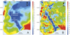 |
Fig. 6 A. Bouguer anomaly map with the Saras Spa concessions. B. First order vertical derivative of Bouguer anomaly map with the Saras Spa surveyed areas. The Campidano Graben with thick Plio-Quaternary sediments is well defined. |
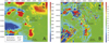 |
Fig. 7 A. Aeromagnetic field anomaly map with Saras Spa concessions. B. First order vertical derivative of reduction to the pole of the total magnetic field with the Saras SpA surveys. One notes the absence of anomalies in the Eleonora area while the Igia area is crossed by an anomaly due to the calc-alkaline volcanics. |
3.4 Deep boreholes
Availability of deep boreholes results was essential for the calibration and interpretation of the seismic data.
In the Northern Campidano in the Oristano-1 borehole (OR-1) cores, well logs, velocity data and biostratigraphy enabled a detailed stratigraphical and sedimentological interpretation (Figs. 4 and 8).
Only the main results will be commented from base to top:
The well bottomed at 1802 m in marine Aquitanian sands overlaid until 1600 m by marine Aquitanian shales. From 1600 m to 1370 m, a section equivalent to the Marmilla Fm on outcrops, composed of marine shales rich in volcano-clastics elements is essentially Early Burdigalian in age. This stratigraphic interval is part of the syn-rift infilling of the SGS (Casula et al., 2001).
From 1370 m to 1000 m, marine shales and sandy marls of Late Burdigalian to Early Serravallian are interpreted as post-rift sediments.
From 1000 m to the MES (Messinian Erosional Surface) at 844 m, Tortonian-Serravallian hemipelagic marls and sands and Early Messinian marine shales were found. Such Tortonian clastics as in many parts of the Mediterranean, are considered as the first indication of the regional inversion caused by a new stage of the convergence of Africa and Eurasia.
Above the MES at 844 m until 798 m, the Early Pliocene marine flooding is observed with shales (Fig. 8). They comprise intercalations of sand and Paleozoic pebbles due to the reworking of clastics resulting from the erosion of the Variscan Basement during the Messinian sea level drop. Marine Pliocene shales (Zanclean and Early Piacenzian) sedimentation continued until 657m.
At 657 m, an abrupt change to a continental environment occurred with the deposition until 94 m of Middle-Late Pliocene continental sands and shales of the Samassi Fm (Pecorini and Pomesano Cherchi, 1969) indicating uplift and erosion. Between 306 m and 322 m, an Upper Pliocene basalt flow can be mapped on the whole area.
From 94 m to the surface, Pleistocene-Holocene fluvial-deltaic environment prevailed with however, short marine incursions at 23 m and 33 m depth.
In the southern Campidano, the Campidano-1 well (Pomesano Cherchi, 1971) (Figs. 5 and 9) played the same role, but the location of the well on a high does not allow a precise regional calibration for the deeper layers.
Comments on the well results are presented with comparison with outcrops and OR-1:
The well bottomed at 1700 m in violin sandy conglomerates with an abundant clayez matrix probably equivalent to the continental Ussana Fm described on nearby outcrops (Pecorini and Pomesano Cherchi, 1969). They are covered from 1520 m to 1153 m, by a thick section of andesites and violin volcanic andesitic debris. It is in accordance with the proximity of an andesitic dome like those outcropping immediately to the east. It is also in agreement with the presence of a magnetic anomaly crossing the SGS (see map Fig. 7B).
An abrupt change occurred at 1153 m, with the deposition of shallow water marls, carbonated sandstones and calcarenites of the Late Aquitanian showing the late arrival of the marine transgression on a high. This interpretation is supported by the presence of rhodalgal carbonates and coral reefs (Villagreca limestone) above Oligocene andesitic domes outcropping eastward. There, the transition from coral reefs to marls is observed and dated Late Aquitanian to Early Burdigalian (Pecorini and Pomesano Cherchi, 1969; Cherchi, 1974; Mancin et al., 2003).
From 1120 m to 900 m, tuffitic marls were dated from Aquitanian to Burdigalian. A reflector at this level was mapped as near-base post-rift sediments. The same lithology of Langhian age was found until 780 m.
From 780 m to 540 m, marine Tortonian and Serravallian marls include several sandstones and conglomerates levels like in OR-1. Here again, it testifies to the beginning of uplift and erosion of this part of Sardinia.
From 540 m to the surface, continental Middle-Late Pliocene Samassi Fm rests unconformably on marine Late Tortonian. In contrast to the Oristano area, neither marine Early Pliocene nor marine Lower Messinian exist to precisely define the MES which here corresponds to a larger hiatus. Marine Lower Pliocene and pre-MES marine Messinian are found again in the southern Campidano (Murru, 1983) and offshore in the Gulf of Cagliari with the Marcella-1 borehole (Casula et al., 2001).
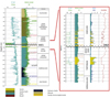 |
Fig. 8 Logs, lithologies and biostratigraphy of OR-1 with enlargement of the Upper Miocene- Lower Pliocene interval showing the two layers with clastics of Tortonian and Lower Pliocene age, below and above the Messinian Erosional Surface (MES). |
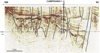 |
Fig. 9 Results of the Campidano-1 well and calibration of a NW-SE seismic profile (See location on Figs. 5 and 14). 1- Base Pliocene (Continental Samassi Fm) 2- Serravallian-Tortonian 3- Burdigalian (Near Base Post-Rift sediments) 4- Upper Aquitanian shallow water limestones 5- Volcanics and Continental conglomerates (Ussana Fm). The well is located on a volcanic high on a magnetic anomaly. In this area, transgression of the see is dated Upper Aquitanian instead of L. Chattian-E. Aquitanian. Marine Messinian and marine Early Pliocene were not preserved contrary to the Northern Campidano (see OR-1 well, Fig. 8). |
4 Geological interpretation of the seismic data in the SGS/North Campidano Graben (Oristano area) (Fig. 4)
In this central part of Sardinia, the Campidano Graben superimposed on the SGS, is N-S oriented. Tectonics was still active recently (this study and ref. in 2.1) with a dissymmetry marked by a more active subsidence to the W along a major fault, the Capo Frasca-Sinis Fault. It is visible in the geography with present deltas deposits with marshes and lakes onshore in the E passing westward to the shallow sea of the Gulf of Oristano. The survey is located onshore with the Oristano-1 well (OR-1) (Fig. 4). Therefore, the Capo Frasca-Sinis Fault is undersea except in the S and N of the studied area.
4.1 Stratigraphic calibration of the seismic survey and structural mapping
One of the seismic profiles W-E oriented, crossed the OR-1 well, allowing a stratigraphic calibration of the seismic survey (Fig. 10)
The well stopped in marine Aquitanian sands some 300-400 m above an interval of strong reflectors found also in the other profiles in the basinal part of the North Campidano. They are interpreted as high amplitude reflectors linked to sheet and mounded turbidites at the toe of clinoforms becoming a strong faulted reflector eastward. The base Aquitanian (red horizon) to the top Lower Burdigalian (green horizon) interval thins considerably to the east where it rests on pre-Aquitanian prograding sediments which will be interpreted on a N-S profile. It is overlaid by the Upper Burdigalian to Messinian marine shales thinning also eastward. One observes that the MES horizon draws a large antiform located on the thickest section of the Miocene sediments below. It shows an inversion of the basin in the Late Miocene. The post-MES Pliocene sediments are unconformable on the deformed and faulted pre-MES sediments.
The whole sedimentary section is highly faulted up to the surface as part of an N-S oriented fault system observed in the whole survey (Figs. 11A and B). To the East, faults are west dipping. Westward, a narrow typical negative flower structure is visible at the level of the OR-1 antiform, limited westward by east dipping normal faults. The faults affect the whole sedimentary section, however, some of them affect the Miocene sediments only, stopping upward at the MES. This is consistent with a pre-MES Late Miocene tectonic event. Their significance will be further discussed with other seismic examples.
The stratigraphic calibration of the horizons allowed drawing several depth structural maps. The base Samassi and the MES maps are presented on which the profiles are located (Figs. 11A and B).
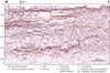 |
Fig. 10 Stratigraphic calibration of the seismic data by OR-1 (location Figs. 4 and 11). Note the intense faulting with flower structures affecting the whole post- Oligocene section including the Upper Pliocene basalts, the Messinian Erosional Surface (MES) and the strong reflectors at the Base Aquitanian-Top Oligocene marine sediments. The pre-MES inversion and presence of pre-MES faults show that the tectonic event started in the Late Miocene and continued until Recent time. |
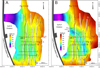 |
Fig. 11 Structural depth maps of the Base continental Pliocene Samassi Fm (Fig. 11A) and of the MES (Fig. 11B). Stratigraphic calibration by OR-1 allowed mapping seismic horizons and the main faults. They show the thickening and deepening of the Plio-Quaternary along the active Capo Frasca −Sinis Fault and the intense Late Miocene to Recent faulting N-S oriented. Four main continuous faults trends (I to IV) are picked and interpreted as strike-slip faults. Figure 11B displays a Messinian paleo-channel whose course was influenced by the Late Miocene tectonic deformations (Cornée et al., 2008). |
4.2 Evidence of a deep graben below the SGS
A N-S profile (Figs. 12A and B) running close the well OR-1, with different acquisition parameters for improving imaging at greater depths, provides the striking evidence of a previously unknown, deeper, thick syntectonic sedimentary section deposited in a half graben below the marine Late Chattian-Aquitanian. It testifies to a pre-Aquitanian strong subsiding phase. At its deepest point on the profile, its thickness is 3 s TWT i.e., about 3 to 4 km. To the SW, the profile shows the steeper side of the half graben but does not cross its bounding fault which corresponds to the Capo Frasca-Sinis Fault (Fig. 3 ). It extends to the W in the Gulf of Oristano. Westward, it is separated from another offshore, small Miocene Graben, not imaged by seismic at depth, by a narrow horst extending from Capo Frasca to the Sinis Peninsula (Fig. 4). By comparison with the Paleogene Continental basins from SE France (Séranne et al., 2021; Semmani et al., 2023; 2024) it can be interpreted as a narrow (20-30 km) trans tensional basin whose age of the base is unknown. It could be as old as late Eocene and includes time equivalent of the post-Pyrenean tectonics Cixerri Formation in addition of the Latest Rupelian-Early Chattian Ussana Formation. It is bounded westward by a major N-S fault with possibly a strike slip component.
Above in the middle of the profile, at about 1700 ms TWT, strong reflectors are visible near the base Aquitanian as already observed on the calibration line (Fig. 10). There is no indication of volcanics on the magnetic anomaly’s maps (Figs. 7A and B) and mapping shows that they are restricted to the central part of the basin. Thus, they are interpreted as high amplitude reflectors, corresponding to distal sheet and mounded turbidites at the toe of clinoforms. Indeed, Miocene prograding systems and fans infill the basin from the South an East and evolved to shales and distal turbidites in the basin centre. Figure 12B, an enlargement of the southern part of the S-N profile Figure 12A, illustrates this sedimentation pattern with deltas fans prograding in a deep marine basin. These observations show that accommodation was created by faulting in the Latest Oligocene-Early Aquitanian allowing the sharp transgression of the sea in the SGS. It is like in the northwestern Mediterranean (Durand-Delga, 1981; Bellaiche et al., 1979), in the Gulf of Lion and in the Marseille and southern Languedoc basins.
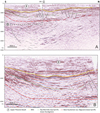 |
Fig. 12 A. The N-S seismic profile (location Figs. 4 and 11) with better penetration, running close to OR-1, discovered below the SGS marine sediments a thick (3 to 4 km) section of syn-tectonic sediments. They could be continental Late Eocene to Late Chattian in age following field studies and comparison with similar basins in southern France (Séranne et al., 2021; Semmani et al., 2023; 2024) (See Sect. 6 Discussion). They were deposited in a narrow half graben (20-30 km wide) bounded westward by the Capo Frasca-Sinis Fault (not crossed by the profile). Above, the strong reflectors at the Base of the Miocene are interpreted as turbidites at the toe of prograding deltas fans (See Fig. 12B) in a deep marine basin resulting from the rifting of Sardinia (SGS). B. Enlargement of the southern part of profile Figure 12A (dotted rectangle on Fig. 12A), stratigraphically calibrated at OR-1. It shows a detail of superimposed deltaic fans prograding from the South, infilling the deep marine Late Chattian Aquitanian to Lower Burdigalian basin of the SGS, with transition to shales and clastics turbidites identified in OR-1. The sediments above the green horizon, Upper Burdigalian to MES in age, onlap the prograding fans and are post-rift sediments. |
4.3 Interpretation of the faults system
In addition to the E-W calibration line (Fig. 10) and the N-S line (Fig. 12), four E-W oriented profiles (Figs. 13A, B, C, and D) south of the calibration line, are presented to better understand the origin of the fault system with flower structures. Their continuity can be studied on the structural maps at the base of the continental Pliocene (Samassi Formation) and at the MES. (Figs. 11A and B).
It allows proving the N-S continuity of the flower structures trends, with four (I to IV) main faults. Indeed, even if the flower structures geometry changes on the N-S direction, a western N-S faulted trend (I) can be followed continuously on all EW profiles and disappear only in the southern part. East of this trend, another N-S faulted zone (II) is characterized by strong internal deformations with reflectors deeming possibly due to gas migrating from deeper layers. Finally, 2 other continuous N-S faulted zones exist eastward. On all these profiles there is evidence of a Late Miocene Pre-MES tectonic event at the origin of the flower structures.
Therefore, in the North Campidano Graben, one observes that: 1- the whole sedimentary section is highly faulted right up to the surface with a geometry of faulting typical of flower structures where faults converge at depth. 2- The tectonic event at the origin of faulting started in the Pre-MES Late Miocene and deformations continued until Recent time. 3- The faults are grouped in several N-S oriented trends which can be followed in the whole survey, along which the style of associated flower structures can change.
This type of fault geometry can be encountered in different settings like in roll-over structures or more generally associated with wrench tectonics (Wilcox et al., 1973; Rodgers, 1980; Woodcock and Fisher, 1986). Typically, one distinguishes negative flower structures characterized by synforms and normal separations and positive flower structures characterized by antiforms and reverse separations (Cunningham and Mann, 2007; Harding, 1985; Holdsworth et al., 1998). A third kind, hybrid, flower structure (Lei Huang and Chi-yang Liu, 2017) is characterized by both antiforms at depth and normal separations. It is generally the case in the N Campidano. Some of the deep faults stop at the MES unconformity demonstrating the pre-MES Late Miocene age for the starting of this tectonic process, but most of them extend upwards until the surface displacing the Upper Pliocene interbedded basalt flows. They converge at depth and cross the high amplitude reflectors of the Base Aquitanian as visible when seismic penetration was sufficient. Their N-S continuity, independent of the orientation of the Capo Frasca-Sinis main Fault, the change of vertical offset observed on a single main fault let to interpret them as a network of strike-slip faults active since the Late Miocene to Present.
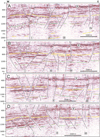 |
Fig. 13 Succession from N to S of W-E seismic profiles. I, II, III and IV referred to the continuous N-S fault trends displayed on the depth structural maps (Figs. 11A and B). The Late Miocene age for the first tectonic deformations is particularly clear on profile A for trend I. The variability of faults geometry appears clearly especially for trend I. The interpretation of the flower structures as strike-slip faults is particularly convincing on trend I profile A and D and on trend II profiles A, C and D. On the trend II on line D, one notes deeming of the seismic data from the bottom to the top of the faulted zone probably linked to upward gas migration. |
4.4 The three tectonic phases
In summary, in this northern area, one observes three superimposed Cenozoic basins resulting from two successive tectonic phases before the rotation of the CSB and a third one after.
1- The oldest one, previously unknown, resulted in a narrow half graben bounded westward by the Capo Frasca-Sinis Fault, infilled by thick (3 to 4 km) probably continental sediments. Their age (Oligocene and post-Pyrenean shortening Eocene?) and significance will be discussed in Section 6.1 by comparison with Paleogene basins of SW France (Semmani et al., 2023, 2024) and results of field studies in SW Sardinia (See Sect. 2 Geological Setting- Pre-Rift Geological Background).
2- A Late Chattian-Aquitanian to early Burdigalian larger graben system is superimposed on the older half graben. It created further accommodation allowing the transgression of the sea with syn-rift marine sediments deposited in deep water environments in its axis. It is the SGS as described by Casula et al. (2001).
3 − The Campidano Graben is superimposed on the preceding basins. Its most subsiding part is bounded to the West by the reactivated Capo-Frasca-Sinis Fault. Continuous N-S oriented strike-slip faults with associated flower structures were active from the Late Miocene to Recent are related to a regional Late Miocene to Present N-S oriented compressional tectonic stress.
5 Geological interpretation of the seismic data in the SGS/South Campidano Graben
While the Campidano Graben is N-S oriented in the Oristano area, it is NW-SE oriented in the South. It extends southward offshore into the Gulf of Cagliari (Fig. 2A), where it was recognized in offshore seismic profiles and by the well Marcella-1 (Casula et al., 2001). To the west, its boundary corresponds to the reactivated faulted boundary of the SGS. To the East, it is bound by a major reactivated fault inside the SGS. More eastward, the SGS sediments are well exposed, and faults are not reactivated during the Plio-Quaternary. The seismic survey (Fig. 8) enabled imaging, like in the north, the Campidano graben, the underlying SGS and sediments below. In surface, only Pleistocene-Holocene sediments outcrop except along its eastern boundary where folded uplifted Pliocene continental sediments and even deeper Miocene sediments outcrop due to tectonic inversion (Figs. 2A and 5) (Carmignani et al., 2001; Casula et al., 2001).
5.1 Stratigraphic calibration of the seismic data
Calibration of the seismic data is done on a NW-SE profile almost crossing the Campidano-1 well (Figs. 5 and 9). The location of the well on a high with magnetic anomalies and the transition to deeper sediments to the SE can be observed. On the high, the continental Pliocene Samassi Fm is unconformable on deformed and eroded Tortonian and reduced Miocene sediments with shallow water Aquitanian carbonates at the base, resting on calc-alkaline volcanics with continental Ussana sediments below. It testifies that a compressional event occurred in the Late Miocene as observed on the outcrops and in the Oristano area to the North. In the deepest area to the SE, interpretation of several horizons until base Aquitanian was possible. It allows building depth structural maps of 3 stratigraphic horizons:1- Base of the Continental Pliocene Samassi Fm (Fig. 14A), the top Lower Burdigalian (Fig. 14B) and base Late Oligocene-Aquitanian (Fig. 14C) of the syn-rift sediments of the SGS.
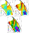 |
Fig. 14 Structural depth maps of three horizons in the central-southern Campidano survey (Igia) with location of the profiles presented: A. Base of the syntectonic continental Pliocene Samassi Formation resting directly on deformed Tortonian. Note thick depocentres (1000 m) and inversion of the E area with erosion of the Miocene. B. Base post-rift Middle-Lower Burdigalian C- Base marine syn-rift Late Oligocene-Aquitanian (Base SGS). The overall tectonic pattern is a wrenched trans pressive basin bounded by Oligocene-Miocene faults reactivated from the Late Miocene to the Recent under a N-S compressional stress. |
5.2 Geological interpretation
Some selected interpreted profiles crossing the Campidano Graben (Figs. 9, 15A, B, 16, and 17) are presented, localized on Figure 5 and on the depth structural maps (Figs. 14A, B and C).
An E-W profile (Fig. 15A) in the northern part illustrates the main characteristics of the sedimentary infilling and faulting. Structurally, two near parallel major faults NNW-SSE oriented, limit the Campidano graben up to the surface (Figs. 14A and B). In between, another oblique N-S oriented fault cuts across a well-defined Miocene half graben with its bordering fault to the east. On the seismic profile, one can distinguish from the surface downward:
The Middle-Upper Pliocene Samassi Fm unconformable on the Miocene succession. Its thickness is controlled by the median fault that separates the Miocene half graben into two parts: to the NW with a thick syn-tectonic Samassi Fm on the deformed underlying Late Miocene and to the SE where the Samassi Fm is very thin on uplifted and eroded Miocene.
The marine Miocene sediments including syn-rift and post rift deposits, thicker (about 1.5s TWT) in the eastern part of the half graben.
The base of the marine Miocene is delineated by a reflector that continues through most of the study area. It was mapped as the near base of the rifting phase starting in the Late Chattian-Aquitanian with marine sediments like in the Oristano area.
Below, there is a series of reflectors, coherent in an interval of about 2 s TWT below the base of the Late Chattian-Lower Miocene syn-rift section. Even deeper, down to 5 s TWT, strong reflections exist but with migration artefacts and probably side arrivals. For these reasons the mapping was not done.
Profile (Fig. 15B), parallel to profile Figure 15A, shows that southward, the throw of the median fault diminishes and is replaced by a typical positive flower structure.
Farther south, a seismic section (Fig. 16) displays a thick sedimentary section of 4 to 5 s TWT which can be correlated with the other profiles to the north.
One note in the Late Chattian-Aquitanian to Lower Burdigalian marine syn-rift, clastic prograding fans originated from both sides of the Campidano Graben passing in the center of the basin to strong horizontal reflectors interpreted as sheeted turbidites. It is the same pattern of infilling of the basin as described above in the North Campidano.
Deeper, organized reflectors in pre-Miocene sediments are visible until 4 s TWT and were interpreted as Figure equivalent of the Late Oligocene Ussana Fm and of the Early Oligocene to Lutetian Cixerri Fm like in the Oristano area in the North. They rest probably on older Eocene and possibly Mesozoic sediments. The profile also illustrates the tectonic inversion of the basin in the eastern side of the Campidano and the westward shift of the syntectonic continental Pliocene Samassi Fm depocenter with a correlative apparent down-lapping of the sediments westward (Fig. 16).
The vintage profile in Figure 17 (see location in Figs. 5 and 14) extends the survey farther east, completing the image of the basin inversion by crossing the major bounding fault along the eastern edge of the south Campidano.
Depth structural maps of different reflectors reveal the tectonic pattern of this part of the Campidano Graben (Figs. 14A, B, and C) and of the underlying SGS.
In particular, the structural depth map of the base continental Lower-Middle Pliocene Samassi Fm (Fig. 14A), which broadly corresponds to a Plio-Quaternary thickness map, illustrates the Plio-Quaternary tectonic regime. The overall pattern is consistent with a right lateral wrench tectonic regime applied on the pre-existing faulted area of the SGS. It caused the reactivation as strike slip faults of two major normal Oligo-Miocene faults bounding the thickest part of the SGS under a broadly N-S regional compressional stress. The result is the long and narrow (around 20 km) Campidano trans pressional basin.
The consequences of this N-S regional shortening are particularly spectacular in this area, with the inversion of the eastern Campidano basin infilling until non-deposition or total erosion of the Samassi Fm and even part of the Miocene. This inversion continues to the SE until Cagliari and farther offshore (Casula et al., 2001). This is consistent with a wrench trans pressional tectonic regime.
In the study area, the structural maps (Figs. 14A, B, and C) show a trough deepening to the SE towards the Gulf of Cagliari with increasing thicknesses of the Plio-Quaternary and Miocene sediments. It shows that most of the Central-South Campidano was a region more uplifted since the Late Miocene than in the North (Oristano area) and in the South towards the Gulf of Cagliari. Indeed, in both areas, marine Messinian and marine Lower Pliocene were preserved.
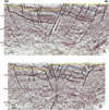 |
Fig. 15 Seismic cross-sections in the central-southern Campidano. A. SSW-ENE interpreted profile crossing the central Campidano Graben (see location on Figs. 5 and 14) and the underlying SGS. Horizons: Yellow= Base Pliocene (Continental Samassi Fm). Blue= Near Top Burdigalian (near Base post-rift). Green= Near Top Aquitanian. Black=Base marine Aquitanian-Top Oligocene (Base of the SGS). The prominent fault (Median Fault) is connected to the northeastern faulted boundary of the Campidano Basin (See Fig. 14). Note the thick pre-SGS section as in the northern Campidano. B. SSW-ENE interpreted profile crossing the Campidano (see location Figs. 5 and 14) parallel to profile Figure 15A. Same markers as on Figure 15A. It shows the transition from the Median Fault to a positive flower structure. |
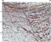 |
Fig. 16 SSW-ENE interpreted seismic section through the southern part of the Campidano (see location on Figs. 5 and 14) with the same markers than in Figure 15. It shows the thick syntectonic pre-Aquitanian (blak marker) sedimentary section like in the northern Campidano. It could include Oligocene and even Late Eocène sediments like in the northern Campidano, and even below older Eocene and Mesozoic. Same markers as on Figure 15A. The black arrow suggests the crest of a tilted fault block bound by a major fault mainly active during the pre-SGS Oligocene. |
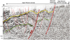 |
Fig. 17 Vintage NE-SW seismic profile (location Figs. 5 and 14) showing the major structural inversion of the Eastern part of the Campidano Graben with the yellow horizon= near Base Samassi and the green horizon= near Base marine Aquitanian-Late Chattian (base SGS). The Monastir Fault is the eastern boundary of the Campidano transpressional basin. The NW-SE oriented inverted structure is mapped on the Geological Map of Sardinia (See Figs. 2A, 3, and 5). |
6 Discussion
6.1 Age, nature, and significance of the thick syntectonic sedimentary section underlying the SGS
An important result of the new onshore seismic surveys in Sardinia is the evidence that, below the base of the syn-rift sediments in the SGS, there is still a much thicker section (3 to 4 km) of previously unknown syntectonic sediments (Fig. 12A). This section, older than the marine sediments dated Late Chattian-Aquitanian on outcrops and in the OR-1 well, is therefore Oligocene in age but its base is not dated. To the north, in the Oristano area, its deposition was controlled by a half graben whose western faulted boundary, not crossed by the profile, is close to the reactivated Capo Frasca-Sinis Fault (Figs. 4 and 11). On the seismic profile, one does not observe important discontinuities in the sedimentary section. Reflectors become more continuous towards its base but still with evidence of the same syntectonic deposition pattern. Therefore, the stratigraphic interpretation is mostly based on outcrops studies in SW Sardinia (See Sect. 2- Geological Setting-Pre-rift Geological Background) and on a comparison with the Paleogene basins in southern France and around the Gulf of Lion. In Sardinia, two post-Pyrenean tectonics sedimentary sequences were defined on outcrops below the marine latest Chattian-Aquitanian developed in the SGS:
The fluvio-lacustrine Cixerri Fm interpreted as a post-tectonic molasse deposited from NW to SE (before rotation of the CSB) with indications of lagoonal-marine environment to the SE. It resulted from the erosion of Pyrenean reliefs NW of Sardinia (before rotation of the CSB). Its base is Middle Lutetian in age, its top is dated Oligocene by microfossils and more precisely by the calc-alkaline volcanics resting on it.
The continental conglomeratic Ussana Fm, clearly syntectonic, whose base is well dated Latest Rupelian-Early Chattian by the calc-alkaline volcanics of the volcanic arc crossing Sardinia from S to N linked to the Apenninic subduction.
Comparison with the Paleogene and Neogene basins in southern France and in the Gulf of Lion provides useful elements for the stratigraphic interpretation (Arthaud et al., 1981; Gorini, 1993; Gorini et al., 1993, 1994; Séranne et al., 1995; Benedicto et al., 1996; Maerten and Séranne, 1995; Mascle and Vially, 1999; Benedicto et al., 1999; Séranne, 1999; Séranne et al., 1999; Sanchis and Séranne, 2000; Guennoc et al., 2000; Oudet et al., 2010; Bache et al., 2010; Séranne et al., 2021; Semmani et al., 2023, 2024). In the Vistrenque Basin (Benedicto et al., 1996; Semmani et al., 2023, 2024) the sediments deposited between the Pyrenean tectonics unconformity and the Late Chattian-Aquitanian marine sediments of the SGS are about 3500 m thick in the deep part of the basin. This is comparable to the thickness of the sediments (3 to 4 km) in the half graben in the Oristano area. Interestingly, in the Vistrenque Basin (Semmani et al., 2023, 2024) the series are divided in to two parts by a conglomeratic “Série rouge” whose base is dated Latest Rupelian-Early Chattian, the same age as the base of the continental conglomeratic Ussana Fm and the onset of the calc-alkaline volcanism in SW Sardinia. The “Série grise” of Priabonian (?)-Rupelian age below, would be (partly?), time equivalent to the continental-lacustrine Cixerri Fm in Sardinia dated Middle Lutetian at its base.
Such thick syntectonic sediments are not restricted to the northern Campidano. They also exist in the southern Campidano (Fig. 16). However, their base is difficult to identify due to the Late Miocene to Recent tectonic inversion, migration artefacts and probable presence of older Eocene and Mesozoic sediments below.
While the SGS crosses the whole of Sardinia from S to N, the prolongation in Northern Sardinia of this deeper basin has not been proven. Seismic data does not exist in this area and the Cixerri Fm has not been described on outcrops. If this basin did not extend to northern Sardinia, another hypothesis would be that its interruption was linked to an important structural feature in Central Sardinia, the Nuoro Fault, a SW-NE sinistral strike-slip fault. It was active after the deposition in E Sardinia of the Middle Lutetian Cucurru and Flores conglomerates a local equivalent of the Cixerri Formation (Dieni et al., 2008). Associated to a trans pressive zone in Eastern Sardinia, the deep basin found below the Campidano from central Sardinia would be its trans tensional counterpart westward. It should include not only the Ussana Fm but also a time equivalent of the Cixerri Formation.
However, structurally, this narrow, elongated, post-Pyrenean tectonics basin is bound to the West by a major fault in the Central and South Campidano, continuing southward offshore. It shows similarities with the trans tensional post-Pyrenean Paleogene basins of Southern France and Gulf of Lion, and it has the same SW-NE orientation (before CSB rotation) (Fig. 18). It controlled the following development of the late Chattian-Aquitanian SGS and thus may correspond to an early phase of the back-arc rift system of the western Mediterranean.
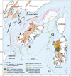 |
Fig. 18 The Cenozoic basins of Sardinia in the geodynamic framework of the Western Mediterranean. Many pre-rifting (tightest)reconstructions exist. In general, they agree linking the Catalan Margin1 with the SW Sardinia Margin and the Provence Margin 2 with the NW Sardinia Margin. Paleogene syntectonic basins preceded the Western Mediterranean Rifting in Sardinia and in SW France and Gulf of Lion. Position A of the CSB (Romagny et al., 2020) corresponds to the early phase of rifting (Aquitanian). The Ligurian-Provençal (LPR) western arm of the Rift System as well as the Eastern Sardinia arm (SGS) display already deep-water environments in their axis. Position B of the CSB is one proposed based on magnetic anomalies (Bayer et al., 1973) for the starting of the formation of the oceanic crust in the Late Burdigalian. Between Position A and B, the LPR was active while the SGS aborted. On the Present position C of the CSB, the Late Miocene to Recent trans pressional Campidano Graben is figured. It is superimposed on the SGS whose faults were reactivated during the Africa-Europe convergence. |
6.2 The SGS
A second tectonic extensional phase with rifting was active from the latest Oligocene-Aquitanian until the early Burdigalian (Casula et al., 2001). It is characterized by the sharp arrival of the sea in the Graben system (Fig. 18) indicating creation of accommodation space. There was a large clastics input from deltas on its eastern and western edges and deep turbiditic deposits in its center. A water depth of about 800 to 1300 m is estimated by seismic reflectors geometry and biostratigraphy (Cherchi and Montadert, 1982). Its thickness does not exceed 2-3 km, but its width is larger (more than 50 km) than the underlying Oligocene basin. It displays a normal extensional fault pattern with tilted blocks and secondary small grabens (Casula et al., 2001). This marine transgression is well known in southern France and the Gulf of Lion (Durand-Delga, 1981; Bellaiche et al., 1979; and references above). 0ffshore, shallow water Aquitanian carbonates were drilled on the most external horst of the Gulf of Lion margin with the GLP-2 well (Cravatte et al., 1974) and marls sampled on the Provence Margin (Bellaiche et al., 1979). It implies the opening of deep corridors between Sardinia and the Balearic promontory and in the SGS itself allowing a transgression of the sea in the rift system. The deep environment observed in the SGS is also in favor of a deep marine environment since the Late Oligocene-Aquitanian in the Ligurian-Provençal rift before the formation of the oceanic crust. However, the marine influence in the Gulf of Lion may be older as indicated by the deposition of evaporites dated Early to Middle Chattian by Pollen Climatostratigraphy in the Vistrenque Basin in Languedoc (S. France) (Semmani et al., 2023).
Thus, the SGS (Fig. 18) is an important structure, part of the northwestern Mediterranean rift system, but contrary to the Ligurian-Provençal rift arm, it failed. It delimited a West Sardinia Block and a single Corsica-East Sardinia Block. The southern boundary of the West Sardinia block corresponds to the major Catalan /Balearic complex transfer-transform zone with large volcanic deposits (Maillard et al., 2020); its northern boundary corresponds to another major transfer-transform fault system along the Provence Margin.
6.3 The Campidano Graben: a Late Miocene to Present transpressional basin linked to the Africa-Eurasia convergence
This study proposes an interpretation of the Campidano basin as a transpressional basin of Late Miocene to Recent age, formed in response to a N-S regional compressional stress.
It is superimposed on the western side of the SGS and bounded by reactivated faults of the Oligocene narrow basin and the SGS. In the northern Campidano (Oristano area), it resulted in the formation of a half graben bounded by a major western boundary fault, active since the Late Miocene and with a dominance of N-S continuous strike slip faults with typical flower structures with bends and/or overlaps with associated local highs (push-ups) and lows (Figs. 11A, B, and 13). They extend to the surface and tend to merge at depth. In the southern Campidano oriented NNW-SSE the resulting deformations are different and correspond to a transpressive wrench system. One observes (Figs. 14A, B, and C): 1- An important Riedel type fault whose orientation agrees with the right lateral major strike slip fault NW-SE oriented bounding the Campidano basin. 2- Mostly the inversion of the basin all along its SE boundary with outcropping and erosion of the Pliocene and even of part the Miocene sediments as shown on the Geological Map of Sardinia (Carmignani et al., 2001) (Figs. 2A, 3, and 5). It extends southward offshore in the Gulf of Cagliari.
The deposition of sands during the Tortonian is the first indication of uplift and erosion of Sardinia. Furthermore, as shown by structural studies on Messinian outcrops (Cherchi & Trémolières, 1984; Casula et al., 2001) and by this study, a change in the tectonic regime occurred with deformation of the pre-MES sediments covered unconformably by marine Lower Pliocene in the northern area or directly by continental syn-tectonic Middle-Upper Pliocene sediments (the Samassi Fm) in the southern area. The continental deposits of the Samassi Fm (300 to 1000 m thick) into the subsiding Campidano basin are associated with a notable uplift of the Paleozoic on the edges of the basin. This is particularly evident in central south-east Sardinia where the Samassi Formation rests directly on deformed Miocene without Lower Pliocene marine sediments. The course of rivers (as the Flumendosa River) east of the Campidano, with meanders incising deeply (400 m) a basaltic plateau proves the uplift. The presence of fossiliferous Burdigalian sediments at a height of 700 m (Tacco di Laconi, east of the Campidano) is another evidence of this uplift. Faulting was still active recently as shown by the seismic data in this study, the Pliocene faulting and volcanism in the Sinis area (N Campidano) (Duncan et al., 2011), the faulting of Pleistocene aeolianites dated 130 to 82 Ka in the same area (Cocco et al., 2019), and faulting of the Pleistocene volcanics West of Oristano.
A N-S regional compressional stress orientation agrees also with the orientation of the Upper Miocene to Pleistocene dyke swarms described in Sardinia and southern France (Feraud and Compredon, 1983) and tectonic observations in Southern France (Larroque et al., 2001). One can also note the similarity between the Late Miocene inversion observed on the Gulf of Lion (Gorini et al., 2005) and the inversion observed in the same period in Sardinia. The tectonic consequences of this regional inversion may have been underestimated in the deep Ligurian-Provençal basin itself (Mauffret et al., 1973) for the highly faulted diapiric zone belt running along the eastern part of the Ligurian-Provençal basin.
The formation of the Campidano pull apart basin under a N-S regional compressional stress regime since the Tortonian is best explained by the convergence of Africa and Eurasia. Compressional stresses in the western Mediterranean absent since the Early Rupelian, were active again since the Late Miocene (Tortonian) (Romagny et al., 2020; Jolivet et al., 2021).
7 Conclusions
Interpretation of new onshore seismic surveys with better imaging at depth has led to significant improvements in understanding the Cenozoic basins of Sardinia and their integration into the western Mediterranean geodynamic framework. The surveys revealed the existence of a previously unknown pre-SGS narrow (20 km) (Fig. 18) half graben, bounded westward by a major N-S fault (N.E-SW before rotation of the CSB) that was later reactivated during the formation of the SGS and the Campidano Graben. This half graben allowed the deposition of thick (3 to 4 km) syntectonic continental sediments, whose base is not dated but could be Late Eocene-Oligocene in age. These sediments could include possibly the post-Pyrenean tectonic Middle Lutetian to Late Rupelian Cixerri Formation and surely the Late Rupelian to Chattian syntectonic Ussana Formation. They could be time equivalent to the Late Eocene to Chattian series described in SW France basins, although with different facies and uncertainties in the stratigraphy of the Eocene.
The surveys confirmed the development of the Sardinia Graben System (SGS) from the Latest Chattian-Aquitanian to the Lower Burdigalian. The SGS, which is more than 50 km wide and 200-250 km long, is part of the wider Western Mediterranean Rift System and is superimposed on the deeper Late Eocene (?) − Oligocene syntectonic basin. The creation of accommodation space allowed a major marine transgression from the south, resulting in a deep-water environment in the axis of the SGS. The SGS is interpreted as a failed arm of the western Mediterranean Rift System, separating a West Sardinia Block from a single East Sardinia-Corsica Block. The presence of deep-water Aquitanian in the SGS, as well as in the Ligurian-Provençal rift, suggests the opening of deep corridors during the Chattian between Sardinia and the Balearic Islands, allowing the transgression of the sea from the south.
The surveys also propose a new interpretation of the Campidano Graben, superimposed on the Paleogene basin and the SGS, as a narrow transpressional basin. This basin results from the reactivation of major faults by an N-S oriented shortening event linked to the Africa-Eurasia convergence. Indeed, regional deformation started again in the Late Miocene (Tortonian) and continued until recent times, in agreement with observations in the Western Mediterranean. This explains the development of strike-slip faults with flower structures and the significant inversion of the southeastern edge of the basin.
Acknowledgments
The authors thank Saras SpA for permission to use their proprietary seismic data which provided a new insight on some aspects of the Geology of Sardinia. We are particularly indebted to Prof. Christian Gorini for its review of the manuscript and its further contribution through scientific discussions, to an updated version of the manuscript. We thank two anonymous reviewers for their in-depth critical analysis of the manuscript and suggestions to improve it. L.Cuilhe (Beicip-Franlab) contributed to the interpretation of gravity and magnetic data. We are indebted to Patricia Gilbert (Beicip-Franlab) and Carole Gicquelet (Beicip-Franlab) for the preparation of the manuscript and to Alexandre Lethiers (University Paris-Sorbonne) for drawing the figures.
References
- AGIP SpA Ente Minerario Sardo. 1979. Carta Aeromagnetica della Sardegna et del Mare circostante. Boll Serv Geol It. 100. [Google Scholar]
- Agus M, Pecorini G. 1978. Livelli a carofite nel Carbone della “prima vena” della miniera di Seruci e nel Cixerri. Res Ass Mineraria Sarda 84: 43–65. [Google Scholar]
- Arragoni S, Maggi M, Cianfarra P, Salvini F. 2016. The Cenozoic fold-and-thrust belt of Eastern Sardinia: Evidences from the integration of field data with numerically balanced geological cross section. Tectonics 35: 1404–1422. https://doi.org/10.1002/2015TC004004. [Google Scholar]
- Arthaud F, Ogier M, Séguret M. 1981. Géologie et géophysique du Golfe du Lion et de sa bordure nord. Bulletin du BRGM 1 (3): 175–193. [Google Scholar]
- Bache F, Olivet J.L, Gorini Ch, Aslanian D, Labails C, Rabineau M. (2010) Evolution of rifted continental margins : The case of the Gulf of Lions (Western Mediterranean Basin). Earth Planet. Sc. Lett., 292, (3-4), 345-356. [Google Scholar]
- Balia R, Ciminale M, Loddo M, Parella D, Pecorini G, Tramacere A. 1991. A new geophysical contribution to the study of the Campidano geothermal area (Sardinia, Italy). Geothermics 20 (3): 147–163. [Google Scholar]
- Balia R, Fais S, Klingelé E, Marson I, Porcu A. 1991. Aeromagnetic constraints on the geostructural interpretation of the southern part of the Sardinian Rift, Italy. Tectonophysics 195 (1991) 347–358. [Google Scholar]
- Barberi F, Cherchi A. 1980. Excursion sur le Mésozoïque et le Tertiaire de la Sardaigne occidentale (16–18 octobre 1980), XXVII Congrès- Assemblée plénière de la C.I.E.S.M. CNR-Progetto Finalizzato Geodinamica-Publ. N. 345 [Google Scholar]
- Barca S, Digregorio F. 1977. Arenaria fossilifera eocenica nel Sarrabus (Sardegna sud-orientale). Boll Soc Geol It 96: 377–386. [Google Scholar]
- Barca S, Costamagna LG. 1997. Compressive “Alpine” tectonics in western Sardinia (Italy): geodynamics consequences. C R Acad Sci Paris (325): 791–797. [Google Scholar]
- Barca S, Costamagna LG. 2000. Il Bacino paleogenico del Sulcis-Iglesiente (Sardegna SW): nuovi dati stratigrafico-strutturali per un modello geodinamico nell’ambito dell’orogenesi pirenaica. Boll Soc Geol It 119: 497–515. [Google Scholar]
- Barca S, Costamagna LC. 2010. New stratigraphic and sedimentological investigations on the Middle Eocene-Early Miocene continental successions in southwestern Sardinia (Italy): Paleogeographic and Geodynamic implications. C R Geoscience 342: 116–125. [Google Scholar]
- Barca S, Palmerini V. 1973. Contributo alla conoscenza degli ambienti di sedimentazione relativi alla Formazione del Cixerri. Boll Soc Sarda Sc Nat 12: 13–50 [Google Scholar]
- Bayer R, Le Mouel JL, Le Pichon X. 1973. Magnetic anomaly pattern in the western Mediterranean. Earth Planet Sci Lett 19 (2): 168–176. [Google Scholar]
- Beccaluva L, Deriu M, Macciotta G, Savelli C, Venturelli G. 1977. Geochronology and magmatic character of Plio-Pleistocene volcanism in Sardinia. Bull Vulcanol 40 (3): 153–158. [Google Scholar]
- Beccaluva L, Civetta L, Macciotta G, Ricci CA. 1985. Geochronology in Sardinia: results and problems. Rend Soc It Min Petr 40: 57–72. [Google Scholar]
- Bellaiche G, Rehaut JP, Vanney JR, Auzende JM, Courmes F, Roure F. 1979. Plongées en submersible dans les canyons méditerranéens : principaux résultats de la campagne Cyaligure. Bull Soc Géol Fr 21 (5): 533–543. [Google Scholar]
- Benedicto A, Labaume P, Séguret M, Séranne M. 1996. Low-angle crustal ramp and basin geometry in the Gulf of Lion passive margin: the Oligocene-Aquitanian Vistrenque graben, SE France. Tectonics 15 (6): 1192–1212. [CrossRef] [Google Scholar]
- Benedicto A, Seguret M, Labaume P. 1999. Interaction between faulting, drainage and sedimentation in extensional hanging-wall syncline basins; example of the Oligocene Matelles basin (Gulf of Lion rifted margin, SE France). In Durand B. et al. eds. The Mediterranean Basins: Tertiary Extension within the Alpine Orogen. Geol Soc London Spec Publ 156: 81–108. [Google Scholar]
- Bourrouilh R. 1973. Stratigraphie, sédimentologie et tectonique de l’île de Minorque et du nord-est de Majorque (Baléares). La terminaison nord-occidentale des Cordillères bétiques en Méditerranée occidentale. Thèse, Université de Paris VI, 1–822. [Google Scholar]
- Bourrouilh R. 1976. In Amaudric du Choffaut S, Campraudon R. eds. C. R. Réunion extraord. Soc. Géol. France, Corse septentrionale 1976. Bull Soc Géol Fr 18: 1173. [Google Scholar]
- Cappetta M, Thaler L. 1973. Présence de poissons Characidae caractéristiques de l’Eocène inférieur européen dans la formation lignitifère de Sardaigne. Rend Sem Fac Sc Univ Cagliari 43: 69–72. [Google Scholar]
- Carmignani L, Carosi R, Disperati L., Funedda A, Musumeci G, Pasci S, et al. 1992. Tertiary transpressional tectonics in NE Sardinia. In Carmignani L, Sassi F.P. eds. IGCP N° 276, Newsletters Vol. 5, Siena 1992, pp. 83–90. [Google Scholar]
- Carmignani L, Barca S, Disperati L, Fantozzi P, Funedda A, Oggiaro G, et al. 1994. Tertiary compression and extension in the Sardinian basement. Boll Geofis Teor Appl XXXVI(141-144): 45–62. March-December 1994. [Google Scholar]
- Carmignani L, (Coord), Barca S, Oggiano G, Salvadori I. 2001. Memorie descrittive della Carta Geologica d’Italia, VLX, 283 pp. [Google Scholar]
- Carmignani L, Decandia FA, Disperati L, Fantozzi AL, Liotta D, Oggiaro G. 1995. Relationships between the Tertiary structural evolution of the Sardinia-Corsica-Provençal Domain and the Northern Apennines. Terra Nova 7. [Google Scholar]
- Carmignani L, Funedda A, Oggiano G, Pasci S. 2004. Tectono-sedimentary evolution of southwest Sardinia in the Paleogene: Pyrenaic or Apenninic Dynamic. Geodinamica Acta 17: 275–287. [Google Scholar]
- Cassano E, Marcello A, Nannini R, Pretti S, Ranieri G, Salvaderi R, et al. 1979. Riliero aeromagnetico della Sardegna e del mare circostante. Notizario tecnico-economico. Ente Minerario Sardo Cagliari/dicembre 1979. Anno VII/ 3–4. [Google Scholar]
- Casula G, Cherchi A, Montadert L, Murru MM, Sarria E. 2001. The Cenozoic Graben System of Sardinia (Italy): Geoadynamic evolution from new seismic and Field data. Mar Petrol Geol 18: 863–888. [Google Scholar]
- Casula G, Cherchi A, Chrest T, Montadert L. 2015. The Oligo-Miocene Graben System of Sardinia (Italy): A novel insight from new seismic profiles and revised biostratigraphy. Soc Geol It. XII Congr. Geosed, Cagliari, 21–27 Settembre 2015. [Google Scholar]
- Chabrier G. 1970. Tectonique du socle d’âge alpin en Sardaigne centro-orientale. CR Acad Sci Paris 271: 1252–1255. [Google Scholar]
- Chabrier G, Mascle G. 1975. Comparaison des évolutions géologiques de la Provence et de la Sardaigne. Revue de Géographie physique et de Géologie dynamique (2), VOL. XVII, FASC. 2, pp. 121–136, Paris, 1975. [Google Scholar]
- Chabrier G, Mascle G. 1984. Structures d’âge alpin en Sardaigne. Revue de Géologie dynamique et de Géographie physique. Vol. 23, Fasc. 2, pp. 69–74, Paris 1984. [Google Scholar]
- Cherchi A. 1974. Appunti biostratigrafici sul Miocene della Sardegna (Italia). V Congr. Neogene Med. (Lyon, 1971). Mém BRGM 78: 433–445. [Google Scholar]
- Cherchi A. 1979. Microfaune aptiano-albianenei ciotolli della Formazione del Cixerri (Sardegna SW) e loro interesse palegeografico. Riv Ital Paleont Stratigr 35: 353–410. [Google Scholar]
- Cherchi A. 1983. Precenza de Ilerdiano a Alveolinidae e Orbitolinidae sul bacino paleogenico del Sulcis (Sardegna SW). Boll Soc Sarda Sc Nat 22 (1982) 107–119. [Google Scholar]
- Cherchi A. (1985) Oligo-Miocene Basin. In : A. Cherchi (Ed) 19th European Micropaleontological Colloquium. Sardinia, Guide book, 338 pp. AGIP. [Google Scholar]
- Cherchi A, Montadert L. 1982. Oligo-Miocene rift of Sardinia and the early history of the Western Mediterranean Basin. Nature 298: 736–737. [CrossRef] [Google Scholar]
- Cherchi A, Marini A, Murru M, Ulzega A. 1978. Movimento neotettonici della Sardegna meridionale. Mem Soc Geol It 19 (1978) 581–597, 1 fig. [Google Scholar]
- Cherchi A, Montadert L. 1984. Il sistema di rifting oligo-miocenico del mediterraneo occidentale e sue consequenze paleogeografiche sul Terciario sardo. Mem Soc Geol It 24: 387–400. [Google Scholar]
- Cherchi A, Schroeder R. 1976. Présence de galets du Vraconien supérieur-Cénomanien basal de provenance ibérique dans le Paléogène continental du Sud-Ouest de la Sardaigne. Bull Soc Géol Fr 18: 1217–1219. [Google Scholar]
- Cherchi A, Simone L, Schroeder R, Carrannante G, Ibba A. 2010. I sistemi carbonatici giurassico-cretacei della Nurra (Sardegna settentrionale. Geological Field Trip, 84° Congr. Naz. Soc. Geol. It. Sassari, 2008. EscurzioneE 05 (2D parte), Genova-Firenze-Torino, (2): 55–122. [Google Scholar]
- Cherchi A, Trémolières P. 1984. Nouvelles données sur l’évolution structurale au Mésozoïque et au Cénozoïque de la Sardaigne et leurs implications géodynamiques dans le cadre méditerranéen. CR Acad Sci Paris 298 (20): 889–894. [Google Scholar]
- Cherchi A, Mancini N, Montadert L, Murru M, Putzu MT, Schiavinotto F, et al. 2008. The stratigraphic response to the Oligo-Miocene extension in the western Mediterranean from observation on the Sardinia Graben System (Italy). Bull Soc Géol Fr 179 (3): 267–287. [Google Scholar]
- Ciminale M, Galdeano A, Gilbert D, Loddo M, Pecorini G, Zito G. 1985. Magnetic survey in the Campidano Graben (Sardinia, Italy): description and interpretation. Boll Geofis Teo Appl XXVII: 221–235. [Google Scholar]
- Cocco F, Andreucci S, Sechi D, Cossu G, Funedda A. 2019. Upper Pleistocene tectonics in western Sardinia (Italy): Insights from the Sinis peninsula structural high. Terra Nova 31: 485–493 [Google Scholar]
- Colom G. 1976. Los depositos continentales aquitanienses de Mallorca y Menorca (Baleares). Rev Acad Ciencias Exact Fis Nat Madrid 70: 353–408. [Google Scholar]
- Cornée J.J, Maillard A, Conesa G, Garcia F, Saint Martin J.-P, Sage F, Münch P. (2008) Onshore to Offshore reconstruction of the Messinian erosion surface in Western Sardinia, Italy : implications for the Messinian salinity crisis. Sed. Geology, 210, 48-60. [Google Scholar]
- Costamagna G, Schäfer A. 2018. Evolution of Pyrenean molassic basin in the Western Mediterranean area: the Eocene-Oligocene Cixerri Formation in the Southern Sardinia (Italy). Geol J 53 (1): 424–437. [Google Scholar]
- Cravatte J, Dufaure P, Prim M, Rouaix S. 1974. Les sondages du Golfe du Lion : Stratigraphie et Sédimentologie. Notes Mem CFP 2: 209–274. [Google Scholar]
- Dieni I, Massari F, Poignant AF. 1979. Testimonianza di Paleocene marino in Sardegna. Riv Ital Paleont 85 (2): 481–516. [Google Scholar]
- Cunningham WD, Mann P. eds. 2007. Tectonics of strike-slip restraining and releasing bends: London. Geological Society, London: Special Publications, Vol. 290, p. 482. [Google Scholar]
- Dieni I, Massari F, Médus J. 2008. Age, depositional environment and stratigraphic value of the Cuccuru e Flores Conglomerate; insight into the Paleogene to Early Miocene geodynamic evolution of Sardinia. Bull Soc Geol France 179: 51–72. [Google Scholar]
- Duncan R, Ginesu S, Secchi F, Sias S. 2011. The recent evolution of the Sinis region (western coast of Sardinia, Italy) on the basis of new radiometric data of the Pliocene volcanism. Geogr Fis Dinam Quat 34 (2011): 175–181, 8 figs. 1 tab. [Google Scholar]
- Durand-Delga M. 1981. Ouvertures océaniques de Méditerranée occidentale et dislocation des chaînes alpines. In: Wezel FC. Ed. Sedimentary Basins of Mediterranean Margins. C.N.R. Italian Project of Oceanography. June 1981. [Google Scholar]
- Elter F, Musumeci G, Pertusati PC. 1990. Late-Hercynian shear zones in Sardinia. Tectonophysics 176: 387–404. [Google Scholar]
- Faccenna C, Speranza F, D’Ajello Caracciolo F, Mattei M, Oggiaro G. 2002. Extensional tectonics on Sardinia (Italy): insights into the back-arc transitional regime. Tectonophysics 356: 213–232 [Google Scholar]
- Feraud G, Compredon R. 1983. Geochronological and structural study of Tertiary and Quaternary dikes in Southern France and Sardinia: an example of the utilization of dike swarms as paleostress indicators. Tectonophysics 98: 297–325. [Google Scholar]
- Fornaciari E, Rio D. 1996. Latest Oligocene to Early Middle Miocene quantitative calcareous nannofossil biostratigraphy in the Mediterranean region. Micropal 42: 1–36. [Google Scholar]
- Funedda A, Carmignani I, Pasci S, Patta ED, Uras V, Conti P, et al. 2009. Note Illustrative della Carta Geologica d’Italia alla scala 1:50.000, Foglio 556, Assemini. APAT − Dipartimento Difesa del Suolo-Servizio geologico d’Italia, Roma, 182 pp. [Google Scholar]
- Gorini Ch. 1993. Géodynamique d’une marge passive : le Golfe du Lion (Méditerranée Occidentale), Thèse de Doctorat, Univ. Paul Sabatier-Toulouse 3, 256 pp. [Google Scholar]
- Gorini Ch, Le Marrec A, Mauffret A. 1993. Contribution to the structural and sedimentary history of the Gulf of Lions (Western Mediterranean) from the ECORS profiles, industrial seismic profiles and well data. Bull Soc Géol Fr 164: 353–363. [Google Scholar]
- Gorini Ch, Mauffret A, Guennoc P, Le Marrec. 1994. Structure of the Gulf of Lions (Northwestern Mediterranean Sea): a review. In : Mascle A. Ed. Hydrocarbon and Petroleum Geology of France. Spec. Publ. Eur. Ass. of Petroleum Geoscientists N°4. 223–243. [Google Scholar]
- Gorini Ch, Lofi J, Duvail C, Tadeu Dos Reis A, Guennoc P, Lestrat P, et al. 2005. The Late Messinian salinity crisis and Late Miocene tectonism: Interaction and consequences on the physiography and post-rift evolution of the Gulf of Lions margin. Mar Pet Geol 22 (2005) 695–712 [CrossRef] [Google Scholar]
- Guennoc P, Gorini Ch, Mauffret A. 2000. Histoire géologique du Golfe du Lion et cartographie du rift oligo-aquitanien et de la surface messinienne. Géol Fr (3), 67–97. [Google Scholar]
- Harding T.P. 1985. Seismic characteristics and identification of negative flower structures, positive flower structures and positive structural inversion. AAPG Bull 69: 585–600. [Google Scholar]
- Holdsworth RE, Strachan RA, Dewey JF, ed. 1998. Continental transpressional and transtensional tectonics. London: Special Publication Vol. 135, p. 360. [Google Scholar]
- Jolivet L, Baudin T, Calassou S, Chevrot S, Ford M, Isautier B, et al. 2021. BSGF − Earth Sciences Bulletin 192: 48. [Google Scholar]
- Larroque C, Bethoux N, Calais E, Courboulex F, Deschamps A, Déverchère J, et al. 2001. Active and recent deformation at the Southern Alps-Ligurian basin junction. Netherlands J Geosci/Geol Mijnbouw 80 (3-4): 255–272. [Google Scholar]
- Lei H. Chi-Yang L. 2017. Three types of flower structures in a divergent-wrench fault zone. JGR : Solid Earth 122 (12): 10,478–10,497 [Google Scholar]
- Letouzey J, Wanesson J, Cherchi A. 1982. Apport de la microtectonique au problème de la rotation du bloc corso-sarde. CR Acad Sci Paris 294: 595–602. [Google Scholar]
- Longhitano SG, Tropeano M, Murru M, Carannante G, Simone L, Cilona A, et al. 2015. Outcrops reservoir analogous and porosity changes in continental deposits from an extensional basin: The case of the upper Oligocene Sardinia Graben System, Italy. Mar Petrol Geol 67: 439–459. [Google Scholar]
- Maerten L, Séranne M. 1995. Extensional tectonics of the Oligo-Miocene Hérault Basin (SE France), Gulf of Lion margin. Bull Soc Géol Fr 6: 739–749. [Google Scholar]
- Maillard A, Jolivet L, Lofi J, Couëffé R, Thinon I. 2020. Transfer Faults and associated volcanic province in the transition zone between the Valencia Basin and the Gulf of Lion: consequences on crustal thinning. Mar Petrol Geol. (in press). [Google Scholar]
- Mancin N, Pirini C, Bicchi E, Ferrero E, Valleri G. 2003. Middle Eocene to Middle Miocene planktonic foraminiferal biostratigraphy for internal basins (Monferrato and northern Apennines, Italy). Micropal 49 (4): 341–358 [Google Scholar]
- Mancin N, Cobianchi M, Di Giulio A, Cattellani D. 2007. Stratigraphy of the Cenozoic subsurface succession of the Venetian-Friulian Basin (NE Italy): a review. Riv Ital Paleont Strat 113 (3): 401–418. [Google Scholar]
- Marini A, Murru M. 1983. Moimenti tettonici in Sardegna fra il Miocene Superiore e il Pleistocene. Geogr Fis Dinam Quat 6: 39–42, Torino [Google Scholar]
- Matteucci R. 1985. Marine Eocene of Sardinia. In: Cherchi A. Ed. 19th European Micropaleontological Colloquium, Sardinia October 1-10, 1985, 80–86 [Google Scholar]
- Mauffret A, Fail JP, Montadert L, Sancho J, Winnock E. 1973. Northwestern Mediterranean Sedimentary Basin from Seismic Reflection Profile. AAPG Bull 57 (11): 2245–2262, 17 Figs. [Google Scholar]
- Mascle A, Vially R. 1999. The petroleum systems of the Southeast Basin and Gulf of Lion (France) In Durand B. et al. eds. The Mediterranean Basins: Tertiary Extension within the Alpine Orogen. Geol Soc London Spec Publ 156: 121–141. [Google Scholar]
- Murru M. 1983. Presenza di Pliocene inferiore nel sottosuelo di Quartu sant’Elena. Boll Soc Sarda Sci Nat 22: 93–08. [Google Scholar]
- Murru M, Matteucci R. 2002. Early Tertiary of Sardinia, Italy. Rend Soc Paleont Ital 1: 269–273. [Google Scholar]
- Oggiano G, Funedda A. 2007. The Sardinia-Corsica block and its role in the Northern Apennine Geodynamics. Boll Soc Geol It 5(n. s): 186–188, 1 fig. [Google Scholar]
- Oggiano G, Funedda A, Carmignani L, Pasci E. 2009. The Sardinia-Corsica microplate and its role in the Northern Apennine Geodynamics: New insights from the Tertiary intraplate strike-slip tectonics of Sardinia. Ital J. Geosci 128: 527–541. [Google Scholar]
- Oudet J, Münch Ph, Borgomano J, Quillévéré F, Melinte-Dobrinescu MC, Demory F, et al. 2010. Land and Sea study of the northeastern Golfe du Lion rifted margin: The Oligo-Miocene of southern Provence (Nerthe area, SE France). Bull Soc Géol Fr 181 (6): 591–607. [Google Scholar]
- Pasci S, Oggiano G, Funedda A. 1998. Rapporti tra tettonica e sedimentazione lungo le fasce trascorrenti Oligo-Aquitaniane della Sardegna NE. Boll Soc Geol It 117 (1998) 443–453, 11 figs. [Google Scholar]
- Pecorini G. 1963. Segnalazione di Eocene fossilifero nella Trexenta (Sardegna meridionale). Rend Sem Fac Sc Cagliari 33 (1-2): 22–26. [Google Scholar]
- Pecorini G, Pomesano Cherchi A. 1969. Ricerche geologiche e biostratigrafiche sul Campidano meridionale (Sardegna). Mem Soc Geol Ital 8: 421–451. [Google Scholar]
- Pomesano Cherchi A. 1963. Discordanze e dislocazioni dell’Eocene nel Gerrei (Sardegna sud-orientale). Mem Soc Geol It III: 707–716. [Google Scholar]
- Pomesano Cherchi A. 1971. Studio stratigrafico e micropaleontologico del pozzo Oristano1 (Sardegna). Mem Soc Geol Ital 10: 1–16. [Google Scholar]
- Pittau P. 1977. Palynological investigation of the lower Tertiary Sardinia Coal layers. Boll Soc Paleont It 16: 3–14. [Google Scholar]
- Pittau Demellia P. 1979. Palinologia e datazione della sezione di Fauca Aru nella valle del Cixerri (Sardegna sud-occidentale). Boll Soc Paleont Ital 18: 303–314. [Google Scholar]
- Raponi D. 2003. Studio pleontologico-stratigrafico di successioni paleogeniche della Sardegna centro-meridionale. Tesi Dottorato di Ricerca in Paleontologia, IV ciclo, 135 p. [Google Scholar]
- Rodgers D. 1980. Analysis of pull-apart basin development produced by en-echelon strike-slip faults. Spec Publ Int Ass Sediment 4 (1980) 27–41. [Google Scholar]
- Romagny A, Jolivet L, Menant A, Bessière E, Maillard A, Canva A, et al. 2020. BSGF − Earth Sciences Bulletin 191 (2020) 37. [Google Scholar]
- Salvadori A. 1980. Contributo alla conoscenza del bacino “carbonifero” del Sulcis. Ind Mine 6: 15–19. [Google Scholar]
- Sanchis E, Séranne M. 2000. Structural style and tectonic evolution of a polyphase extensional basin of the Gulf of Lion passive margin: The Tertiary Alès Basin, Southern France. Tectonophysics 322: 243–264. [Google Scholar]
- Sau A, Lecca L, Ionis R, Secchi F, Fercia ML. 2005. La seconda fase del Rift Sardo: vulcanismo ed evoluzione dei sub-bacini di Ardara-Chilivani e Bonorva (Sardegna settentrionale). Boll Soc Geol It 124 (2005) 3–20, 6ff., 2 tabb. [Google Scholar]
- Savelli C, Beccaluva L, Deriu L, Macciotta G, Maccioni L. 1979. K/Ar geochronology and evolution of the Tertiary calc-alkalic volcanism of Sardinia (Italy). J Volc Geoth Res 5: 257–269. [Google Scholar]
- Semmani N, Fournier F, Suc JP, Fauquette S, Godeau N, Guihou A, et al. 2023. The Paleogene continental Basins from SE France: New geographic and climatic insights from an integrated approach. Paleogeogr Paleoclimat Paleoecol 615 (3): 11452. [Google Scholar]
- Semmani N, Fournier F, Suc JP, Fauquette S, Séranne M, Léonide P, et al. 2024. The continental depositional record of climate and tectonics around the Eocene-Oligocene transition in the Vistrenque Basin (Camargue, Southeast France). BSGF −Earth Sciences Bulletin 195: 8. [Google Scholar]
- Séranne M, Benedicto A, Truffert C, Pascal G, Labaume R. 1995. Structural style and evolution of the Gulf of Lion Oligo-Miocene rifting: rôle of the Pyrenean Orogeny. Mar Pet Geol 12 (8): 809–820. [Google Scholar]
- Séranne M. 1999. The Gulf of Lion continental margin (NW Mediterranean) revisited by IBS: An overview. In : Durand B. et al. ed. The Mediterranean basins: Tertiary Extension within the Alpine Orogen, Geol. Soc. London, Spec. Publ., 156: 15–36. [Google Scholar]
- Séranne M, Sanchis E, Benedico A, Seguret M. 1999. Succession d’épisodes de rifting Eocène terminal à Miocène dans le sud de la France : Rift Ouest Européen ou rifting du golfe du Lion? Volcanismes, Sedimentations et Tectoniques Cénozoiques Périalpines. Docum B.R.G.M. 291 : 1–42. [Google Scholar]
- Séranne M, Coueffé R, Husson E, Baral C, Villard J. 2021. The transition from Pyrenean shortening to Gulf of Lion rifting in Languedoc (South France)- A tectonic-sedimentation analysis. BSGF − Earth Sciences Bulletin 192 : 27. [CrossRef] [EDP Sciences] [Google Scholar]
- Trémolières P, Cherchi A, Schroeder R. 1984. Phénomènes de chevauchement d’âge Pyrénéen dans le Mésozoïque du Nord-Ouest de la Sardaigne. CR Acad Sci Paris 298: 797–800. [Google Scholar]
- Vardabasso S. 1952. Guida alle excursioni. Cong Soc Geol It 56 (1952) 1–75; Soc Geol It 21(1955): 159-179. [Google Scholar]
- Vardabasso S. 1959. Il Mesozoico epicontinentale della Sardegna. Acc Naz Lincei Rend Cl Sc Fis Mat S827: 178–184. [Google Scholar]
- Wilcox R, Harding TP, Seely DR. 1973. Basic Wrench Tectonics. AAPG Bull 57 (1): (January 1973) 16 Figs, 1 Table. [Google Scholar]
- Woodcock NH, Fischer M. 1986. Strike-slip duplexes. J Struct Geol (7): 725–735. [Google Scholar]
- Zattin M, Massari F, Dieni I. 2008. Thermochronological evidence for Mesozoic-Tertiary tectonic evolution in the eastern Sardinia. Terra Nova 20: 469–474. [Google Scholar]
Cite this article as: Allevi C, Casula G, Cherchi A, Chrest T, Montadert L. 2025. The Cenozoic basins of Sardinia (Italy) and their Late Miocene to Present inversion: insight from new seismic data, BSGF - Earth Sciences Bulletin 196: 14. https://doi.org/10.1051/bsgf/2025010
All Figures
|
Fig. 1 Sardinia in the western Mediterranean realm. Morpho-bathymetric map from CCGM-CGMW (Paris December 2010) with 1: the Oligo-Miocene Sardinia Graben System (SGS) and 2: the Campidano Graben. Circles illustrating the rotation of the Corsica-Sardinia Block (CSB) do not represent the probable multi-stages motion of the CSB. |
| In the text | |
|
Fig. 2 A. Schematic geological map of the Sardinia Oligo-Miocene Graben (SGS) and of the superimposed Late Miocene to Recent Campidano Graben (Cherchi and Montadert, 1982) with the location of the two Saras Spa surveys (Eleonora and Igia) on the Campidano Graben. Area of deposition of the Cixerri Fm (Middle Lutetian to Late Chattian) is indicated with sediments transport direction. B. Schematic cross sections through the SGS (Cherchi, 1985). Sediments thickness is very underestimated in the grabens. Morphology shows that the area of extension is wider than the area where syn-rift sediments are preserved. Surveys are located on the Campidano Graben (sections B and C) about 20 km wide superimposed on the SGS about 100 km wide. |
| In the text | |
|
Fig. 3 The Central and Southern Sardinia Oligo-Miocene Graben System on the Sardinia Geological Map with the 2 Saras Spa surveys located in the Campidano Graben with the OR-1 and Campidano − 1 wells. |
| In the text | |
|
Fig. 4 The Saras Spa Eleonora survey (North Campidano) on the Geological Map of Sardinia with location of the new seismic lines and of the Oristano-1 (OR-1) well. Profiles presented in the publication are in red. |
| In the text | |
|
Fig. 5 Location of the Saras Spa seismic survey in the Central-South Campidano on the Geological Map of Sardinia with the Oristano-1 well. Profiles presented in the publication are in red. Note the basin inversion on the E side of the Campidano. |
| In the text | |
|
Fig. 6 A. Bouguer anomaly map with the Saras Spa concessions. B. First order vertical derivative of Bouguer anomaly map with the Saras Spa surveyed areas. The Campidano Graben with thick Plio-Quaternary sediments is well defined. |
| In the text | |
|
Fig. 7 A. Aeromagnetic field anomaly map with Saras Spa concessions. B. First order vertical derivative of reduction to the pole of the total magnetic field with the Saras SpA surveys. One notes the absence of anomalies in the Eleonora area while the Igia area is crossed by an anomaly due to the calc-alkaline volcanics. |
| In the text | |
|
Fig. 8 Logs, lithologies and biostratigraphy of OR-1 with enlargement of the Upper Miocene- Lower Pliocene interval showing the two layers with clastics of Tortonian and Lower Pliocene age, below and above the Messinian Erosional Surface (MES). |
| In the text | |
|
Fig. 9 Results of the Campidano-1 well and calibration of a NW-SE seismic profile (See location on Figs. 5 and 14). 1- Base Pliocene (Continental Samassi Fm) 2- Serravallian-Tortonian 3- Burdigalian (Near Base Post-Rift sediments) 4- Upper Aquitanian shallow water limestones 5- Volcanics and Continental conglomerates (Ussana Fm). The well is located on a volcanic high on a magnetic anomaly. In this area, transgression of the see is dated Upper Aquitanian instead of L. Chattian-E. Aquitanian. Marine Messinian and marine Early Pliocene were not preserved contrary to the Northern Campidano (see OR-1 well, Fig. 8). |
| In the text | |
|
Fig. 10 Stratigraphic calibration of the seismic data by OR-1 (location Figs. 4 and 11). Note the intense faulting with flower structures affecting the whole post- Oligocene section including the Upper Pliocene basalts, the Messinian Erosional Surface (MES) and the strong reflectors at the Base Aquitanian-Top Oligocene marine sediments. The pre-MES inversion and presence of pre-MES faults show that the tectonic event started in the Late Miocene and continued until Recent time. |
| In the text | |
|
Fig. 11 Structural depth maps of the Base continental Pliocene Samassi Fm (Fig. 11A) and of the MES (Fig. 11B). Stratigraphic calibration by OR-1 allowed mapping seismic horizons and the main faults. They show the thickening and deepening of the Plio-Quaternary along the active Capo Frasca −Sinis Fault and the intense Late Miocene to Recent faulting N-S oriented. Four main continuous faults trends (I to IV) are picked and interpreted as strike-slip faults. Figure 11B displays a Messinian paleo-channel whose course was influenced by the Late Miocene tectonic deformations (Cornée et al., 2008). |
| In the text | |
|
Fig. 12 A. The N-S seismic profile (location Figs. 4 and 11) with better penetration, running close to OR-1, discovered below the SGS marine sediments a thick (3 to 4 km) section of syn-tectonic sediments. They could be continental Late Eocene to Late Chattian in age following field studies and comparison with similar basins in southern France (Séranne et al., 2021; Semmani et al., 2023; 2024) (See Sect. 6 Discussion). They were deposited in a narrow half graben (20-30 km wide) bounded westward by the Capo Frasca-Sinis Fault (not crossed by the profile). Above, the strong reflectors at the Base of the Miocene are interpreted as turbidites at the toe of prograding deltas fans (See Fig. 12B) in a deep marine basin resulting from the rifting of Sardinia (SGS). B. Enlargement of the southern part of profile Figure 12A (dotted rectangle on Fig. 12A), stratigraphically calibrated at OR-1. It shows a detail of superimposed deltaic fans prograding from the South, infilling the deep marine Late Chattian Aquitanian to Lower Burdigalian basin of the SGS, with transition to shales and clastics turbidites identified in OR-1. The sediments above the green horizon, Upper Burdigalian to MES in age, onlap the prograding fans and are post-rift sediments. |
| In the text | |
|
Fig. 13 Succession from N to S of W-E seismic profiles. I, II, III and IV referred to the continuous N-S fault trends displayed on the depth structural maps (Figs. 11A and B). The Late Miocene age for the first tectonic deformations is particularly clear on profile A for trend I. The variability of faults geometry appears clearly especially for trend I. The interpretation of the flower structures as strike-slip faults is particularly convincing on trend I profile A and D and on trend II profiles A, C and D. On the trend II on line D, one notes deeming of the seismic data from the bottom to the top of the faulted zone probably linked to upward gas migration. |
| In the text | |
|
Fig. 14 Structural depth maps of three horizons in the central-southern Campidano survey (Igia) with location of the profiles presented: A. Base of the syntectonic continental Pliocene Samassi Formation resting directly on deformed Tortonian. Note thick depocentres (1000 m) and inversion of the E area with erosion of the Miocene. B. Base post-rift Middle-Lower Burdigalian C- Base marine syn-rift Late Oligocene-Aquitanian (Base SGS). The overall tectonic pattern is a wrenched trans pressive basin bounded by Oligocene-Miocene faults reactivated from the Late Miocene to the Recent under a N-S compressional stress. |
| In the text | |
|
Fig. 15 Seismic cross-sections in the central-southern Campidano. A. SSW-ENE interpreted profile crossing the central Campidano Graben (see location on Figs. 5 and 14) and the underlying SGS. Horizons: Yellow= Base Pliocene (Continental Samassi Fm). Blue= Near Top Burdigalian (near Base post-rift). Green= Near Top Aquitanian. Black=Base marine Aquitanian-Top Oligocene (Base of the SGS). The prominent fault (Median Fault) is connected to the northeastern faulted boundary of the Campidano Basin (See Fig. 14). Note the thick pre-SGS section as in the northern Campidano. B. SSW-ENE interpreted profile crossing the Campidano (see location Figs. 5 and 14) parallel to profile Figure 15A. Same markers as on Figure 15A. It shows the transition from the Median Fault to a positive flower structure. |
| In the text | |
|
Fig. 16 SSW-ENE interpreted seismic section through the southern part of the Campidano (see location on Figs. 5 and 14) with the same markers than in Figure 15. It shows the thick syntectonic pre-Aquitanian (blak marker) sedimentary section like in the northern Campidano. It could include Oligocene and even Late Eocène sediments like in the northern Campidano, and even below older Eocene and Mesozoic. Same markers as on Figure 15A. The black arrow suggests the crest of a tilted fault block bound by a major fault mainly active during the pre-SGS Oligocene. |
| In the text | |
|
Fig. 17 Vintage NE-SW seismic profile (location Figs. 5 and 14) showing the major structural inversion of the Eastern part of the Campidano Graben with the yellow horizon= near Base Samassi and the green horizon= near Base marine Aquitanian-Late Chattian (base SGS). The Monastir Fault is the eastern boundary of the Campidano transpressional basin. The NW-SE oriented inverted structure is mapped on the Geological Map of Sardinia (See Figs. 2A, 3, and 5). |
| In the text | |
|
Fig. 18 The Cenozoic basins of Sardinia in the geodynamic framework of the Western Mediterranean. Many pre-rifting (tightest)reconstructions exist. In general, they agree linking the Catalan Margin1 with the SW Sardinia Margin and the Provence Margin 2 with the NW Sardinia Margin. Paleogene syntectonic basins preceded the Western Mediterranean Rifting in Sardinia and in SW France and Gulf of Lion. Position A of the CSB (Romagny et al., 2020) corresponds to the early phase of rifting (Aquitanian). The Ligurian-Provençal (LPR) western arm of the Rift System as well as the Eastern Sardinia arm (SGS) display already deep-water environments in their axis. Position B of the CSB is one proposed based on magnetic anomalies (Bayer et al., 1973) for the starting of the formation of the oceanic crust in the Late Burdigalian. Between Position A and B, the LPR was active while the SGS aborted. On the Present position C of the CSB, the Late Miocene to Recent trans pressional Campidano Graben is figured. It is superimposed on the SGS whose faults were reactivated during the Africa-Europe convergence. |
| In the text | |
Current usage metrics show cumulative count of Article Views (full-text article views including HTML views, PDF and ePub downloads, according to the available data) and Abstracts Views on Vision4Press platform.
Data correspond to usage on the plateform after 2015. The current usage metrics is available 48-96 hours after online publication and is updated daily on week days.
Initial download of the metrics may take a while.