")
")
| Issue |
BSGF - Earth Sci. Bull.
Volume 197, 2026
|
|
|---|---|---|
| Article Number | 3 | |
| Number of page(s) | 23 | |
| DOI | https://doi.org/10.1051/bsgf/2025020 | |
| Published online | 16 February 2026 | |
A long postglacial rhyolitic activity of the Icelandic Krafla volcano during the Eemian: limited impact of glacio-isostasy
Une longue activité rhyolitique postglaciaire du volcan Islandais Krafla depuis le début de l'Éémien (mis 5e): impact limité de la glacio-isostasie
1
Geo-Ocean, UMR 6538, IUEM, Place N. Copernic, 29280 Plouzané, France
2
Sorbonne Université − Cergy Paris Université − CNRS, Institut des Sciences de la Terre de Paris (ISTeP) − UMR 7193, 4 place Jussieu, 75252 Paris CEDEX 05, France
3
Geological Institute ehf Hólshrauni 7, Is-220 Hafnarfjörður, Iceland
* Corresponding author: brigitte.vanvlietlanoë@univ-brest.fr
Received:
29
January
2025
Accepted:
23
September
2025
Abstract
Tephrostratigraphy in marine cores is an important tool for dating sedimentary sequences along the North Atlantic and in Western Europe. Most previously analyzed marine tephra were produced by Icelandic volcanoes, albeit rarely from the Krafla volcano, and require land-based records for validation. Two series of rhyolitic tephra emitted to the east of the Krafla volcano were recorded in the Eemian Rangá Formation in Northern Iceland, the two series being separated by the Grímsvötn 1 tephra known as “5e low bas IV” in marine core (∼127 ka). These rhyolitic deposits were seemingly ejected from the Hágangnahali paleocrater row (North of the Hágöng) and overlay the older Halarauður Ignimbrite. This rhyolitic activity persisted for ∼20 ka to the end of the Eemian last thermal optimum. probably initiated by deglaciation (MIS 6a/5e). It postdated the Halarauður ignimbrite. The ignimbrite and caldera formation were correlated with an ODP907 tephra, yielding a possible 207 ka age, but possibly older. These results constrain the main rhyolitic activity of Krafla to after the mid-Pleistocene transition, as observed for other “two-magma” volcanoes. Rhyolitic activity is non-systematically triggered by deglaciation, at least as analysed during the period 80–400 ka, but this genetic link is possibly valid for the late Pliocene of Iceland.
Résumé
L’utilisation de la téphrostratigraphie des carottes marines est un outil important pour la datation des séquences sédimentaires dans l’Atlantique Nord et en Europe de l’Ouest. La majorité des téphras marins analysés sont issus des volcans islandais, mais rarement à partir du volcan Krafla, et nécessitent des enregistrements terrestres pour être validés. Deux séries de téphras rhyolitiques émis à l’est du volcan Krafla ont été observés dans la formation éémienne Rangá, dans le nord de l’Islande, les deux séries étant séparées par le téphra Grímsvötn 1 connu sous le nom de “5e low-bas IV” dans les carottes marines (∼127 ka). Ces dépôts rhyolitiques semblent avoir été éjectés de la rangée de paléocratères de Hágangnahali lors de la Terminaison II (MIS 6a/5e), et se poursuivent jusqu’à l’achèvement du dernier optimum thermique de l’Éémien, largement après la mise en place de l’ignimbrite de Halarauður. Un âge de ∼207 ka, voire plus ancien, a donc été associé à cette ignimbrite et à la formation de la caldeira par corrélation avec un téphra de ODP 907. Ces résultats limitent l’activité rhyolitique principale du Krafla à une période postérieure à la transition du Pléistocène moyen, comme cela a été observé pour d’autres volcans "à deux magmas". L’activité rhyolitique n’est pas systématiquement déclenchée par une déglaciation, du moins telle qu’elle a été analysée pendant la période 80-400 ka, mais elle pourrait être valable à partir de la fin du Pliocène islandais.
Key words: Deglaciation speed / isostatic unloading / rhyolitic and two magma events / correlation with tephrostratigraphy / marine and Greenland cores / MIS 5 to MIS 8
Mots clés : Vitesse de déglaciation / décharge isostatique / activités rhyolitiques et à deux magmas / corrélations avec la téphrostratigraphie / Atlantique dans les carottes marines et groenlandaises / MS 5 à MIS 8
© B. Van Vliet-Lanoë et al., Published by EDP Sciences 2026
 This is an Open Access article distributed under the terms of the Creative Commons Attribution License (https://creativecommons.org/licenses/by/4.0), which permits unrestricted use, distribution, and reproduction in any medium, provided the original work is properly cited.
1 Introduction
Iceland is an atypical volcanic island formed by the superposition of the mid-Atlantic oceanic rift crossing a major hot spot (cf. synthesis in Van Vliet-Lanoë et al., 2021).
Moreover, Iceland has been covered by ice caps since at least 3 million years, which appears to affect volcanic activity, both in terms of volume, geochemical signatures and types of volcanism (cf. synthesis in Van Vliet-Lanoë et al., 2021), especially for rhyolitic lava’s. Volcanic activity is admitted being low when the ice caps are at their maximum extent and mainly develops during interglacial periods, from deglaciation which is interpreted to reflect the role of the ice overload (glacio-isostasy, Jull and McKenzie 1996; Maclennan et al., 2002). Partial to total ongoing deglaciation of the island is identified in Pleistocene stratigraphy as the “Termination”.
Icelandic magma reservoirs are formed by the coalescence of fault bundles (Guðmundsson, 1996, 2000; Guðmundsson, et al., 1996), either superficial (about 2-3 km deep, e.g., superficial Grímsvötn and Krafla), or deeper in a basi-crustal or even sub-crustal position at the brittle-ductile boundary of the lithosphere (about 12-20 km). Commonly evolved lava compositions (andesite to rhyolite) and compositional heterogeneity are considered as typical of early-erupted units, reflecting tapping of the upper, more silicic zones of a compositionally heterogeneous superficial reservoir undergoing chaotic mixing. Later-erupted deposits are often more homogeneous in composition and grade smoothly upward from andesite to basalt, reflecting tapping of denser hybrid magma and uncontaminated basalt from lower in the chamber (Rooyakkers et al., 2022). Consequently, the setting of rhyolitic tephra is generally considered as the result of unloading related to some glacial termination (Sigvaldason 2002; Cooper et al., 2010; Harning et al., 2014).
Several volcanoes (Fig. 1) were reactivated during the last Termination Ib, such as Katla (silicic ash from Vedde 11,3 to 11,2 ka cal BP; Harning et al., 2024) and Grimsvötn (basaltic ash from Saksunarvatn ∼10,2 ka cal BP, Óladóttir et al., 2020). Hekla, Katla, Askja, and Krafla, among other volcanoes, usually reset their activity in form of an initial "two magma" major event, followed in time by episodic series of rhyolite emission ending with basaltic lava’s (Jónasson, 2007; Jakobsson et al., 2008). The silicic Vedde ash resulted from multiple eruptions in 300 yr (Harning et al., 2024), as did the Askja volcano during the Preboreal stage of the Holocene (> 4 events; ∼ 1300 yr; Sigvaldason 2002; Óladóttir et al., 2020; Van Vliet-Lanoë et al., 2020) but continued recently with a powerful one in 1875. Other volcanoes, such as the Tindfjall, exhibit seemingly similar behavior. During Pleistocene, the stratigraphic attribution (MIS 8, 7 or MIS 5e) or the dating of the emitted lava is of prime importance to analyse the triggers for eruptive event, as termination or not. Most of them are extracted from age model in marine corings but only very few isotopic dating in the field.
Beside punctual dating, Quaternary stratigraphy in Iceland mostly ignores the presence of the last Interglacial in the recorded inland sections despite our published stratigraphical papers with isotopic dating (e.g., Guillou et al., 2010, 2019, Fig. 1). Data for the Eemian tephra from Iceland and from marine or lacustrine cores are limited and only dated by age models with less frequent records from terrestrial records (Abbott et al., 2018). An outstanding sedimentary complex covering late Marine Isotopic Stage 6 (MIS 6) to MIS 5c was mapped and dated from inland to the coast of Iceland between 1997 to 2018 (Van Vliet-Lanoë et al., 2001 to 2020; Fig. 1), the Rangá Formation. This stratigraphic series is sandwiched between MIS 6b or older glacial units, lava or hyaloclastites, and Preboreal deglaciation tillites/end moraines . The Rangá Fm also includes several tephra deposits that fit the Eemian record compiled by Abbott et al. (2018). Askja volcanic complex in the NVZ is suspected (Sigvaldason 2002) to have produce a first serie of rhyolite around 10 ka relative to Termination I (dated by tephrostratigraphy).
In this paper, we document the stratigraphic position of volcanic activity during the Last Interglacial and older deposits in northern Iceland and the various tephra records around the island (marine core), and especially in complex tidal, lacustrine and fluvioglacial deposits in an Eemian formation. This Rangá formation has been first defined in southern Iceland (Van Vliet-Lanoë et al., 2018), and is well preserved in active rift zones, particularly in the South and the North Rift Zones under the last glacial deposits, even close to the Vatnajökull ice cap (500-1500 m asl; Van Vliet-Lanoë et al., 2010 (Figs. 1 and 2C). This Rangá Fm recorded several tephra, including a basaltic key one from the Grίmsvötn volcano, the 5e low-IV Bas tephra, generally assigned to 127 ka BP (Abbott et al., 2018), but also from the Krafla volcano. The Krafla volcano is predominantly basaltic but with acidic phases (dacites and rhyolites) in early eruptions. Its Holocene activity is episodic, occurring every 250–1000 yr, each episode lasting 10–20 yr (Ármannsson et al., 1987). The time interval between its "two magma” eruptions ranges from only 30 to 200 yr during the Holocene (Larsen et al., 2019). Distal tephra recorded and dated from marine core are compared with our finding in the North volcanic zone (NVZ), and especially those issued from this Krafla volcano.
This work also allows to attribute to the MIS 7 the major complex Halarauður ignimbrite, located to the east of the present Krafla caldera. This dating contrasts with the previously proposed eruption of this magma during the late MIS 5, which was not clearly identified in marine core. Accordingly, the major ignimbrite event most probably occurred close to 207 ka BP, which is also consistent with regional outcrops indicating in this paper that a younger interglacial rhyolitic activity of the Krafla volcano persisted for at least 20 ka after Termination II.
 |
Fig. 1 Map of extent of the Rangá Formation in Iceland, with the key sites related with U-Th and Ar-Ar dating, active volcanoes and hyaloclastite ridges (from Guillou et al., 2010, 2020, 2023). |
 |
Fig. 2 Global and simplified stratigraphy (A) of the Rangá Fm adapted from Van Vliet-Lanoë et al., 2018. In red: main rhyolite deposits or bodies; B) Glacio-eustatic curve (black) for the Rangá Fm for Northern Iceland adapted and completed from Van Vliet-Lanoë et al., 2018 (South); H11: Heinrich 11 event. GIR: Global Isostatic Rebound). Global Eemian sea level curve (green, from Medina-Elizalde, 2013). C) Kárahnjúkar − Halslὀn dam section (Van Vliet-Lanoe et al. 2010). Rangá Fm section : upper MIS 5: D and E units, with paleosols, river deposits with bioturbations. |
2 Methods
Fieldwork in 2003 and 2017-2018 in the North of Iceland is the main basis for this work. A large image collection from fieldwork 1995-2018 has been reused for this specific approach. These data were completed by image analysis of satellite and aerial pictures to find the potential source zones for the volcanic emissions. Aerial image issues from the Icelandic Cartographic Institute (Loftmyndir ehf., Iceland) and its web site https///map.is (recently based on Maxar pictures). The other series of satellite images is available in Google Earth Pro, at about the same precision and updated each year (various sources). The locations of the described sites are available on https://www.map.is/ and Google Earth Pro, and their geographic coordinates are provided in Annexe 1. The published tephrostratigraphic records in the literature provided a base to establish correlations with the oceanic records (Van Vliet-Lanoë et al., 2018).
Geochemical and microscopic analysis of the tephra were performed in the Brest University Geochemical Laboratory (France), with the help of Professor René Maury † and compared to the available data from the literature, especially the papers from Christian Lacasse and Shane Rooyakkers. Dating was obtained by U-Th, K-Ar and 40Ar/39Ar on intraformational basalts and rhyolites performed by Hervé Guillou and his collaborators (Guillou et al., 2010, 2019, 2020, 2023) in the LSCE/IPSL Geochronology Laboratory at Gif/Yvette (France). Dating attempts often failed related to a very low K content of the rocks, probably issued from long-lasting interglacial weathering.
3 Genesis of rhyolites
Rhyolites represent in Iceland around 10% of the rocks (Sæmundsson, 1979) and this proportion reaches or exceeds 20% in many central volcanoes with “two magma eruptions” (Jónasson, 2007; Jakobsson et al., 2008), volcanoes on the periphery of the Icelandic hotspot. The petrogenetic relationships between Icelandic rhyolites and associated basalts are currently considered to derive from the partial melting, at the base of the Icelandic crust, of partly altered ancient oceanic crust and abundant hyaloclastites, generating dacite-type magmas which evolved to rhyolitic residual liquids by fractional crystallisation coupled with assimilation of the basaltic casing of the magma reservoirs (Martin and Sigmarsson, 2010), leading to silica-rich lavas (dacites, rhyodacites and tholeiitic rhyolites). However, most magmatic series resulting from fractional crystallisation processes with melting facilitated by the high geothermal gradients of the rifts as for NVZ. In this case, basaltic magmas began their evolution by assimilation coupled with fractional crystallisation within a deep magmatic reservoir located at around 18-20 km depth in the crust. Then the transition from intermediate liquids (ferrobasaltic) to tholeiitic rhyolitic magmas took place in a much more superficial relay reservoir (i.e. around 3 km; Kuritani et al., 2011).
4 The Krafla volcano and the north volcanic zone
Faulted zones in Northern Iceland (NVZ) form a ∼100 km long, sub-parallel fissure swarm, including the Krafla and Askja volcanoes, subparallel to the Bárðarbunga swarm to the south (Figs. 1 and 3; Hjartardóttir, 2013). The Krafla volcano is indirectly connected to the Kolbeinsey oceanic ridge (North Atlantic), offset to the west by the Tjörnes Fracture Zone (TFZ) with a limited but direct influence on the Krafla volcano magmatism (Hooft et al., 2006). From the aerial views and the radar pictures (Map.is), one inland prolongation of the TFZ (Fig. 3), the Húsavík-Flatey fault zone (HFFZ) and the Dalvik lineament (DAFZ) cross the Krafla faults swarm, visible as fractures North of the Eilífsvötn lake and as relief constraining to the South of the Hágöng plateau and the central part of Krafla central volcano, explaining its location. This is also visible along the Jökulsá á Fjöllum River (Fig. 3). Some constraints from the Kolbeinsey Ridge could perhaps influence the magmatism, like on the Reykjanes peninsula in South Iceland.
Geyer and Bindeman (2011) suggested that the Krafla caldera could not develop under an ice cap but resulted from hydrothermal weathering that favoured hyaloclastite and secondary rhyolite accumulation in shallow magma reservoirs. Such hydrothermal activity is common during deglaciation events: to trigger the emptying of the reservoir and caldera collapse, the unloading by ice sheet thinning will open the drainage faults in conjunction with rifting events, erupting thus from early deglaciation but continuing further after deglaciation (Guðmundsson, 2007).
The dominant mechanism for producing silicic magma for the Krafla volcano is a partial melt of the hydrothermally altered crust by gentle hydration. It mostly concerns crust of basaltic composition or old hyaloclastites ridges (Sigmarsson et al., 2022). Fresh basaltic intrusions into former hydrothermally altered basalt should melt the hydrated parts at relatively low temperature (850–950 °C) and "extract" a “light” silicic magma, which then migrates upwards, forming sills at shallow depths (Sigmarsson et al., 2022). Bimodal eruptive (“two magmas”) activity could be explained by buoyant silicic magma accumulated above the shallow basaltic reservoir, enhanced by heat flow from the mantle that behaves as heating source for the geothermal system and explosive Plinian eruptions. Major basalt intrusion(s) may “ignite” them, causing a silicic eruption, and the cycle starts again (Sigmarsson et al., 2022). In this case, basaltic magma intrusion should be potentially related to the hotspot or to the Kolbeinsey ridge activities (Ármannsson 1987; Hartley and Þórðarson 2013). Most of the reginal rhyolitic tephra in the Ranga Fm were spread to the east, in argument with the oblique slope near the lateral edge of fissure swarms and perhaps the ring fault induced by the caldera collapse induced by the emptying of the subsurface magma reservoir (Weber and Castro 2017).
 |
Fig. 3 Tectonic control: faults (plain) and lineaments (dotted) of the Tjörnes Fracture Zone (TFZ), composed inland by the so-called Dalvik (DAFZ) and Húsavík-Flatey (HFFZ) fault zones, in pink. Conjugate faults in green. Main NVZ rifts swarms in black (major faults). The TFZ connects the NVZ to the Kolbeinsey North Atlantic Ridge 30 km westward. Extracted from Map.Is. |
5 Pleistocene stratigraphy : the regional MIS 5e interglacial records in Iceland (land and sea)
5.1 Generalities
Widely observed in the South beneath the terminal moraines of the last glaciation, Holocene loesses and lavas, the Rangá Fm often rests here on dated basalts at ∼155 ka (Fig. 1; Guillou et al., 2010) and often older ablation or basal tillites. The Rangá Fm consists of brown-orange consolidated sands of fluvio-glacial to coastal origin which has been isotopically dated at ∼116 ka by U disequilibrium, instead of U/Ar, due to an intense paleo-weathering (Andosol), MIS 5c in age (Van Vliet-Lanoë et al., 2018; Figs. 1 and 4). The Rangá Fm sediments were derived from the reworking of subglacial hyaloclastite ridges, or Tuya, formed around 150 ka (U-Th dating on Fig. 1) that were active from MIS 6b onwards, during a long but cool interstadial within an extensive glaciation (Fig. 4).
Consolidation is mainly linked to the diagenesis of Andosol neoformed allophane into nontronite (ferruginous smectite) or sometimes into montmorillonite (well-crystallised smectite; see Annexe 2), due to the aridity prevailing during the early Last Glacial period. The geochemistry (Annexe 3) of lower and upper consolidated tephra, sampled in Kvíar B site brough confirmation of the Krafla tephra source; it resulted from a semi-lacustrine deposition, evident from the field observations, completed by weathering (ignition loss).
The Rangá Fm recorded a continuous Termination II linked to a rapid deglaciation and most of the Eemian sensu lato, from MIS 5e to MIS 5a (Fig. 4) present a MI 5e with evidence of two marine “high stands” or maximum flooding surfaces (MFS) separated by a marked “regression phase”, often associated with loesses and tillites, the sedimentary response to a complex intra-Eemian glacial re-advance (Van Vliet-Lanoë et al., 2018). This cooling was correlated to the Greenland glacial stage GS 26 (120-116 ka BP; Irvali et al., 2016; Fig. 4). In the NVZ, this formation crops from the Vatnajökull to the coast (Jökulsá á Fjöllum) to Öxafjörður (Fig. 1), in connexion with the active NVZ.
Paleolakes, tillites, paleo-permafrost, paleosols and tephra were recorded with lavas flows from the Vatnajökull to the South and North coasts (Van Vliet-Lanoë et al., 2010, 2018). The thick Grim 1 (Grimsvötn) basaltic tephra is recorded close to the base in most investigated Rangá Fm sections. It is commonly deformed to the top by large loadcasts (earthquakes), and very often reworked by subglacial floods, the jökulhlaups
 |
Fig. 4 A) Record of the Marine Isotopic Stages (MIS, in bold letters) during Quaternary based on Railsback et al., 2015. https://railsback.org/Fundamentals/SFMGSubstages01.pdf; Lisiecki and Raymo, 2005). The chronological emplacement of the Krafla rhyolitic activity (Kr) recognized or interpreted from the marine core and field data records are compared to the two potential periods for the Halarauður ignimbrite setting (yellow). Grίmsvötn Saksunar tephra = Grim Sak (see text), Kvíar indicates the main setting periods for MIS 5 rhyolite (located on both banks of the Jökulsá á Fjöllum river. VPDB: 13C/12C isotope ratio for Vienna Peedee belemnite. B) The δ18O record of the Greenland ice core NGRIP between 60 and 125 ka (NGRIP Members 2004) on the GICC05 model time scale (Andersen et al., 2004; Svensson et al., 2008). GI = Greenland interstadial; GS = Greenland stadial. The temperature shift between stadial and interstadial is accorded to Landais et al. (2005) and Capron et al. (2010). Original data was downloaded from https://www.iceandclimate.dk/data. Onset of the Southern Hemispher (SH) warming reveal a potential arrival of the mild Irminger current in the Greenland Strait. |
5.2 MIS 6- to MIS 5 tracing tephra
The Grimsvötn volcano emitted a major tephra during MIS 5e (Grim 1) equating the earliest basaltic tephra from the North Atlantic cores (“5e low bas-IV”; Abbott et al., 2018) and dated at ∼127 ka based on age model, the first climate optimum of the MIS 5e interglacial (Figs. 2, 5, and 6). Grim 1 tephra is commonly recorded in the Rangá Fm both in the North and the South, systematically reworked by huge jökulhlaups, immediately below the MFS levels.
In the South, the Hekla volcano was mainly responsible for huge lava splays and basaltic tephra, also known as well on land as in marine core in both glacial Terminations (I and II). It was also responsible for rhyolite domes and tephra recognized inland (Óladóttir et al., 2020).
In the North, a similar situation for the Krafla volcano seemed to exist upstream of the MFS. The lower Rangá Fm, seismicity remained relatively low during Termination II, the ongoing unloading, recorded in the Normellur depression (Syðra in older papers) and western Kvíar outcrops (Kvíar A), close to Dettifoss (Figs. 7 and 8). Here, the Grim 1 tephra was recorded in fluvio-glacial sediments shifting to a pure basaltic layer before evolving back to fluvio-glacial before truncation, as in southern Iceland. It was very rapidly deformed by low-magnitude seismic activity in most of the sites, independent from the Grim 1 event. This means that after the setting of Grim1 tephra, the first MFS recorded a nearly full deglaciation, reaching an MFS at 244 m asl, the local water table remaining high, in relation to the progress inland of the glacio-isostatic rebound (GIR, Fig. 2B). During the Eemian Interglacial (MIS 5e), the Hekla volcano was responsible for several rhyolitic tephra, especially a very early one metric in size (Fig. 5A), preserved in the basal units (transition MIS 6 / MIS 5e), below the Grim1 tephra. Thin layers only were deposited during the second deglaciation (GI 25, 116-113 ka; Van Vliet-Lanoë et al., 2018). Last Holocene deglaciations (Fig. 2), were often phreatic but purely basaltic in-between.
Similarly, in the NVZ, volcanoes like the Krafla and Askja (Árnason, 2020) had occasional silicic eruptions during the Termination I. During the very early Holocene, the Askja volcano recorded a similar trend with a series of successive eruptions (Van Vliet-Lanoë et al., 2020), although the present caldera formed only recently in 1875 AD (end of the Little Ice Age), with a large Plinian eruption (Þórðarson and Larsen, 2007). Here, a wide splay of faulted interglacial basalts, mapped as Eemian on the geological map (Sæmundsson et al., 2012), was issued at least from the Krafla and Þeistareykir volcanic complexes. These old basalts are covered or infiltrated by the dated Rangá Fm as at Vikingavatn (Fig. 1, North coastline) and in a fault swarm, near the Mὀfell tuya (Fig. 7). The Rangá Fm also exists in the infilling of the Húsavík fault at the coast (Van Vliet-Lanoë et al., 2018; Fig. 3).
The regional preservation in the vicinity of the active Krafla volcanic system of old rhyolitic tephra that include pumice fragments, with a homologue geochemistry is a key for the understanding of our observations, as this volcano regularly produces rhyolites nearby the Kvíar site (17 km only). The interglacial paleolakes) evidenced within incomplete Rangá stratigraphy (resulting from intra-formational erosion) the record of two rhyolitic tephra series, probably deposited in a freshly deglaciated plain. A more rapid glacio-isostatic unloading of the first 40 km (perhaps calving glacier front) from the coast could explain the persistence of a high-water table. Present valley slope is today at 4 ‰, but somewhat steeper from the coast to the N1 road (Figs. 1 and 7) than the whole valley slope from the Vatnajökull. These paleolakes probably extended in indirect connection with the high Eemian marine limit in front of Vesturðalur (187 m; Fig. 7).
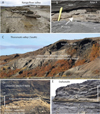 |
Fig. 5 A) Major Hekla rhyolitic tephra at the base of the Rangá Fm, 1 km east of Galtalækur (right bank of the Ytri Rangá river, South Iceland). B) upper Kvíar rhyolite including about 2-5 mm pumice fragments (arrow), at Kvíar A site. C) “Þórsmörk Ignimbrite” from Tindafjell “two-magma” eruption, 358 ± 15 ka. D) multiple eruption of the Askja volcano, near East of the Ljósavatn (Preboral). E) multiple eruption of the Krafla volcano (upper Kvíar series, ∼127-123 ka) quarry of Daðastaðir (NE coast of Öxarfjörður). The age of this raised beach postdated the upper marine limit, evaluated in South Iceland to 127 ka (Van Vliet-Lanoë et al., 2018). |
 |
Fig. 6 Various records of the Grim 1 (127 ka) tephra (Grímsvötn volcano) in the Rangá formation. A) Rangá formation in southern Iceland, topped by the lower tidal sedimentation and seismites (100 m asl); B) Kvíar A site: the Grim 1 tephra at the base of the section, overlapped by glacio fluvial sedimentation deformed by seismic load casts. C) Kvíar A lacustrine basal sedimentation on lodgement tills with a welll individualised dark layer of Grim 1 tephra. D) Preservation at Vesturðalur East of Grim 1 tephra in between the condensed Kvíar rhyolithics series. |
 |
Fig. 7 Location of all the northern sites with evidence of rhyolitic tephra including fragments of pumices (in red) and tephra splays (pink) and the Krafla volcano caldera. |
 |
Fig. 8 Kvíar A Eastern outcrop. Evidence of at least two sets of rhyolitic tephra: upper Kvíar and lower Kvíar Series. These are separated by the resedimented Grim1 tephra (see also Fig. 7C). Rhyolitic tephra are whitish at the base off the Rangá Fm and yellow orange, for younger splays. It may shift to orange with weathering (andaosols with limited basaltic content). |
6 Termination II unloading (139 to 132 ka) and the local Eemian marine inondations
6.1 Generalities
Termination II is thought to have begun around 139 ka BP in Antarctica, with a major warming resulting from global isolation forcing on the Southern Hemisphere only (Schulz and Zeebe, 2006; Turney et al., 2020), similar but more abrupt and stronger than these of Termination I (Fig. 4) . Mostly based on tephrostratigraphy, two marine inundations (Fig. 2B) were recorded briefly inland during the MIS 5e, first driven by glacioisostasy, reaching respectively for the first MFS; ∼127 ka Grim1 tephra, at its base), 215 m asl in the Ytri Rangá Valley (Rangávellir) in the South and 244 m asl along the Bárðardalur River in the North (parallel to the Jökulsá á Fjöllum River, about 50 km to the West; Fig. 1). A basal and local rhyolitic tephra of the Hekla volcano (Fig. 5A; South) and a basaltic one, issued from Grimsvötn volcano (Grim1; Fig. 5) largely splayed, followed by a major load cast level, recording specific seismic events series during the very early interglacial as well in the North and the South of the island. The second very brief high stand (MFS) reached 168 m in the South, and 189 m asl in the North (Figs. 2B and 7 at Vestudalur).
Along the Jökulsá á Fjöllum, in the North, the consolidated Rangá Fm crops mainly from the seaboard (Fig. 1: Öxarfjorður) to the vicinity of the Vatnajökull ice cap, splaying along the Krafla and Askja central volcanoes. Marine facies crop near the coast, at Vikingavatn, resting on an old lava paleocliff. Our mapping in the North revealed the presence of the Rangá Fm, nearby the Krafla central volcano with rhyolitic tephra series, limited to the East, along the Jökulsá á Fjöllum river (Fig. 7). These are also preserved to the coastline, close to Daðastaðir (Figs. 1 and 5E), in a buried and consolidated marine raised beach, with series including dispersed millimetric pumice and several layers of partly remoulded rhyolitic tephra, onlapped by consolidated fluvioglacial series under a discordant Late Glacial lodgement till as also locally, above the Ásbergy touristic site (146 m asl, Malar on Fig. 1), in a sandy subtidal facies that includes at his base a reworked thick basaltic tephra (Grim 1) resting on a rhyolitic-rich tidal one. Upstream, in front of the Vesturðalur site (Fig. 5) on the right bank of the Jökulsá á Fjöllum River, the paleo-jökulhlaup activity was still very dynamic. The youngest flooding surface cropped there at 189 m asl. It consists of sandy tidalites with large bioturbations locally separated by a periglacial loess from the relicts of the lower tidal unit. The base basaltic tephra (Grim 1) is commonly sandwiched between two rhyolitic tephra along the Jökulsá á Fjöllum River.
6.2 Main sections
In front of the Vesturðalur site (on the right bank of the Jökulsá á Fjöllum River), the paleo-jökulhlaup activity was very dynamic. The youngest flooding surface cropped there at 189 m asl. It consists in sandy tidalites with large bioturbations locally separated by a periglacial loess from the relicts of the lower tidal unit. The base basaltic tephra (Grim 1) is sandwiched between two rhyolitic tephra.
Further south and west of Kvíar (on the left bank), above the MFS, the same sequence is observed with first up to 4 m of lacustrine sandy silts, a rhyolite rich facies resting directly on an ablation tillite, from 334 to 338 m asl. Commonly, two rhyolitic tephra in this lacustrine unit were separated from a latter thick basaltic tephra: the Grim 1 one, reworked by jökulhlaups all along the Jökulsá á Fjöllum river (right bank). In Kvíar A site, the Grim1 tephra is commonly topped by co-seismic involutions and framed by at least two series of rhyolithic tephra. This tephra was observed Southeast of Kvíar, in the paleolake Normellur or “Syðra Normelsfjell” (in Van Vliet-Lanoë et al., 2001).
7 Rhyolitic tephra in the key Kvíar and Normellur sections
The present morphology of the outcrops is related to erosion by Holocene jökulhlaups and similarly during the MIS 5e. Most of the mapped outcrops with these Kvíar and Normellur paleolakes seem exactly in the continuation of the youngest rhyolitic eemian emissions (Fig. 7; in red), spread to the east of the Krafla volcano with some limited and residual outcrops in a range of 50 km. The valley of the Eilífsvötn lake (Fig. 7) probably partly channelled the pyroclastic flows. The stratigraphy of Kvíar A and Normellur sites revealed at the base an undulating ablation tillite on a lodgement till with an irregular topography helping to preserve the loamy sand lacustrine series, locally topped by a brown-orange Andosol.
The basaltic Grim 1 tephra preserved in temporary lakes revealed in most of the sections an initial progressive invasion of the topography by jökulhlaup deposits, further concentrated in basaltic tephra (Grim 1) but progressively diluted at the end of the event (most of the sections). This single deposit was brief and prograding in the Normellur (Fig. 9; Van Vliet-Lanoë et al., 2005).
This Grim 1 event is clearly separating at Kvíar A site the two series of rhyolitic tephra (Fig. 8), including pumice fragments (2–5 mm in size; Fig. 4B). The basaltic Grim 1 tephra is followed by a sand silt level with loads cast underlined by thin layers of rhyolitic tephra (Fig. 8).
This seismic crisis was observed both in the north and south of Iceland, perhaps related to the onset of this upper series. The lower Kvíar series consists most often of two main layers of rhyolitic tephra (5-20 cm thick), the lower being whitish and preserved at the base of most sections near the road N1 (Fig. 7).
The upper Kvíar series is composed of at least 7 layers (Fig. 8) probably a dozen from Google Earth images 2023, including a thick rhyolitic doublet (5–10 cm). Another relict Andosol weathered the late sequence in Normellur site and was attributed to the MIS 5c interstadial (early Glacial: Fig. 4; Van Vliet-Lanoë et al., 2001).
7.1 The rhyolitic Krafla paleo-tephra source
An analysis of the available satellite images from the websites, Map.Is and Google Earth Pro on the Krafla surrounding revealed that the rhyolite series are constrained within a limited aera, east of the Krafla volcano (Fig. 7). Also, two potential emission zones were defined on the Hágöngur relief (Fig. 10):
1) an old one, strongly glacially smoothed from which the dacite / ignimbrite emissions seem to relate to the faults of the Krafla swarm system and was partly collapsed with the caldera ring faults.
2) South of the youngest, three patches of more recent stratified rhyolitic tephra or of welded tuff onlapped the Halarauður ignimbrite emission zone, and two on the ignimbrite outcrop (Figs. 9C and 9D) with similar facies (color) as these observed for the Kvíar and Normellur sites, excepted a pronounced fracturation (Fig. 9C) suggesting a proximal welded tuff setting.
3) In the north, the traces of 3 emissive rhyolitic craters (Hàganhanali) are visible, splayed by late basaltic ejecta (Figs. 9A and 9B), and partly smoothed by erosion.
4) Immediately to the north, the east fault of the Krafla fault swarm is used for late, limited emission of basaltic pyroclasts that ended the latest activity with lava’s (Fig. 10B).
 |
Fig. 9 Normellur paleolake sections. A) condensed rhyolitic deposits to the North, topped by the orange, brown paleo-andosol (MIS 5c)l. B) view of the depression with the eroded formation, paleosols and rhyolites. C-D-E) main section with, at the base, the Grim tephra remolded by a jökulhlaup: (C). D and E: fluvioglacial deposits largely enriched in rhyolitic pumices of the Kvíar lower Series. |
7.2 The Krafla caldera and the Halarauður ignimbrite (Figs. 7 and 9)
The 50 km2 caldera (10 to 8 km wide) was induced by an explosive Plinian eruption producing dacitic welded tuff immediately followed by an eruptive complex known as the Halarauður ignimbrite (Calderone et al., 1990; Rooyakkers et al., 2020, 2022). This 50-meter-thick ignimbrite complex (± 7 km3 magma) splayed multiphase with late-erupted basaltic lava, together with a major collapse event of the caldera. This was related to the emptying of a main and shallow differentiated magma reservoir. The Halarauður ignimbrite age was estimated “officially” at ∼110–115 ka (40Ar/39Ar; Sæmundsson and Pringle, 2000). The acidic phases of the volcanism were further responsible for rhyolitic domes (Fig. 7) formed after the caldera around the Krafla. These yielded ages of 88.7 ± 9.9 ka for Jörundur, 83.3 ± 9.2 ka for Hlíðarfjall, and 85.5 ± 9.4 ka for Gæsafjallarani (Hampton et al., 2021).
The base of the Hiðarfjall dome (West of the Víti crater, northern caldeira of the Eskja) has been dated 94.4 ± 2.6 ka (Ar-Ar, Guillou et al., 2023), thus in early MIS 5b. As the Halarauður ignimbrite is also overlapped by this ∼94 ka dacite (Fig. 7), its age is thus possibly older than 110 ka or as early as the inception of MIS 5e (Fig. 4). The geochemistry of the late domes is like the ignimbrite complex (Lacasse and Garbe-Schönberg, 2001; Rooyakkers et al., 2022), an argument for a single and shallow magmatic reservoir. Moreover, comendite lava’s have been observed by a coring in the present caldera (Friðleifsson et al., 2014). The main explosive eruption of Halarauður ignimbrite produced volcanic plumes estimated at >7 km high (Calderone et al., 1990; Rooyakkers et al., 2020, 2022), thus able to be recorded in marine core at least NNE of Iceland. The isotopic date of the ignimbrite (Sæmundsson and Pringle, 2000) probably corresponds from the age estimation from tephrostratigraphy to the “welded” crust of Kvíar tephra series pasted on the ignimbrite (Figs. 10C and 10D), penecontemporaneous of the dated dacite domes that reused the caldera ring faults, as the Kvíar-emiting Hàganhanali crater row (Fig. 9A).
 |
Fig. 10 A) Hágöng surface analysis based on Google Earth picture (Airbus image). B) detail of the Hàganhanali crater row emission zone. C) relict of the Kvíar rhyolitic splay on the Halarauður emission zone. D) relict of the Kvíar rhyolitic splay on the basaltic cover of the Halarauður ignimbrite (south of Fig. A). Beta letter for a late basaltic lava flow from the Kvíar series. |
8 Discussion
8.1 The Kvíar tephra serie
Commonly, two but up to a dozen rhyolitic layers are recorded in the lower Rangá deposits along the Jökulsá á Fjöllum. Most of them are preserved below and immediately above the Grim1 basaltic tephra in association with synchronic jökulhlaup sedimentation, related with a large subglacial eruption. The nearby Askja as recorded in published data, apparently did not produce rhyolite at that time in marine core
For orbital forcing constraints, the warming of Termination II occurred from ∼139 ka in Antarctica, transmitted to the Northern Atlantic as today by the thermohaline circulation. A date of 132 ka is generally accepted for the early Eemian rise in the Northern Atlantic temperature (Andersen et al., 2004). South of Greenland, in MD03 32664 core, a sudden and maximal ice melting occurred from 130 ka, along the Eirik rift (Irvali et al., 2016), also marked by IRD (ice rafted debris) sudden rise in sediments and a warming in summer SST (sea surface temperature) in ODP980 core, NW of Ireland.
Deglaciation first started in Iceland, in conformity with the first SST limited warming at 135 ka observed in MD03 32664 core (Figs. 4 and 11) and interrupted by the H11 Heinrich cooling (Irvali et al., 2016), explaining the 136 ± 5 ka dating of the Gerðuberg interglacial lava, signing the deglaciation of the Snæfellsnes peninsula (Fig. 1; Guillou et al., 2010).
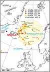 |
Fig. 11 Synthetic compilation of rhyolitic tephra issued from the Krafla volcano (red star), found in deep sea core (from Wallrabe-Adams and Lackschewitz, 2003; Lacasse and Garbe-Schönberg, 2001; Wastegård and Rasmussen, 2001). Direct aeolian sedimentation mostly yielded the NNE, along the Kolbeinsey Ridge, as also recorded in the field in northern Iceland. Other outcrops are related with marine currents and sea-ice transportation. |
8.2 Grim 1 tephra
The ongoing deglacial unloading also explained thus the main Grim 1 tephra at 127 ka in marine core (Abbott et al., 2018) as also in the Rangá Fm, corresponding to a major emptying of the volcanic reservoir of Grimsvötn volcano related to the first thermal optimum of MIS 5e interglacial (Van Vliet-Lanoë et al., 2018). We would thus suggest for the lower Kvíar rhyolitic tephra an approximate age of 136-127 ka, as Grim 1 was splayed in early interglacial position and correlated to the Eemian 5e Low Bas tephra IV (∼127 ka Abbott et al., 2018) in marine core and in terrestrial one (LINK 16; Wastegård and Rasmussen, 2001). This tephra is found in the South and the North of the the Rangá Fm, with huge jökulhlaups activity on a freshly deglaciated paleotopography (Van Vliet-Lanoë et al., 2010; 2018).
8.3 Lower Kvíar series
The origin of the Lower Kvíar A series in the Rangá Fm is, based on field data, directly related to a deglaciation (Termination II). The stratigraphic position of a Krafla rhyolite in marine core MD985 (Lacasse and Garbe-Schönberg, 2001) is estimated from ∼133 to ∼126 ka ( ODP907) by correlation with LINK 16 (Wastegård and Rasmussen 2001). It probably corresponds to the second-thickest splay at the base of Kvíar A, which seems associated with a major glacial unloading for the Krafla system, emptying of part of the Krafla shallow magma reservoir (Figs. 3 and 7), already differentiated at the end of MIS 6. We can therefore assign an age of ∼133-127 ka to the Lower Kvíar tephra.
8.4 Upper Kvíar series
The upper rhyolitic tephra from the Kvíar A series resting directly on the Grim1 tephra. These multiple emissions probably occurred from ∼127 ka to possibly ∼124 ka and therefore correspond to the ’Mid Rhy tephra” in the MD 985 marine core (Abbott et al., 2018). In the South, a similar timing, 126 ka, has been obtained near the present summit for the Tindfall Volcano (Moles, 2019). As the Grim 1 event is brief, relative to the sedimentary conditions, this second Kvíar series could extend to the end of the Thermal Optimum (GI 26) near ∼120 or 119 ka (Fronval et al., 1998, Fig. 4). During the second Eemian Optimum (GI 25, 116-113 ka; Fronval et al., 1998), evident rhyolitic activity was also recorded (Abbott et al., 2018).
Lacasse and Garbe-Schönberg (2001) reported in North Atlantic ODP Site 985 and Site 907 an inventory of Icelandic silicic volcanism for the last six million years. In this compilation, in ODP Site 907, two older silicic tephra were observed at ∼201 ka, and ∼ 207 ka, attributed to a Krafla source. The volume of the Halarauður ignimbrite is very important in the field compared to those of the Kvíar rhyolites series. Two series of craters exist to the NW of the Hágöng (Fig. 10).The potential source for the Halarauður ignimbrite is apparently observed south of the Hàganhanali crater row on the new geological map (Sæmundsson et al., 2012) and the Google Earth pictures. This very smoothed old crater row is discretely pasted by the late consolidated and stratified Hàganhanali rhyolite tephra (Kvíar A series) as well as also on the Halarauður ignimbrite. The glacially smoothed Grjὀthals old Tuya (Figs. 7 and 10) presents also a thin rhyolitic cover splayed to the NNE, issued from the Hàganhanali crater row and preserved to the north-east, as the eastward Kvíar-Normellur rhyolitic ejecta. This also fit in marine core the eastward-directed blast for the “133 ka” of Abbot et al., 1998 reaching the ODP 985 and 907 positions (Fig. 11), but much younger than the stratigraphic potential position for the Hágöng complex ignimbrite
8.5 Chronology and deglaciation
Even though the last glacial stage (MIS 5c) in Iceland is normally considered to have started at about 110 ka BP (synthesis in Árnason, 2020), it should be suggested here that an inner caldera was formed 80 ka ago in sub-aerial eruption(s) forming the rhyolitic domes Hlíðarfjall, Jörundur, and Rani outside the “110 ka” caldera (following dating by Sæmundsson and Pringle, 2000). At 80 ka, an ice advance Guillou et al., 2010) occurred at Skardesengi.
8.5.1 The Kvíar series
From the age evaluation in the marine core containing MIS 5e rhyolitic ash layers, it can be first estimated that the deposition of the corresponding tephra layer occurred between 130 ka and 125 ka BP (Wallrabe-Adams and Lackschewitz, 2003). As the Lower Kvíar rhyolitic series issued before the 127 ka (Grim 1 tephra) and after the 136 ka coastal Gerðuberg lava (Guillou et al., 2010), the suggested age of 133 ka (Wastegård and Rasmussen 2001) seems correct with the 5e Low Rhy, in Abbott et al. (2018).
The upper part, the Kvíar A series, splayed above on Grim1, could therefore correspond to the mid-stage 5e ash zone (∼125 ka) following Wastegård and Rasmussen (2001), which consisted in marine cores of a mixture of rhyolitic and basaltic-intermediate tephra particles, the Mid Rhy. This ash zone occurred necessarily before a major cooling event responsible for glacial readvance in altitude (beginning of GS 26,∼ 120-116 ka in Fronval et al., 1998). This should suggest a rhyolitic tephra emission for the Krafla volcano that persisting from ca. 133 to 123–110 ka, the end of the two MIS 5e thermal optima, the GI27 and GI26 116-113 ka, very similar to the “∼110–115 ka ignimbrite” (Sæmundsson and Pringle, 2000) issued from the Hágangnahali crater row (Figs. 10A and 10C), the most probable source of welded rhyolite tuff crust locally preserved on the Hágöng basement, and the Kviar series along the western side of the Jökulsà à Fjölum River. No younger evidence was preserved :
The first evidence of Weischeslian glacial advance (MIS 4) has been observed at Skardsengi (, 65°N27 15°W 50) just North of the Askja system, dated on basalt at ∼80 ka, like in most Northern Atlantic.
8.5.2 The Harlarauður ignimbrite
Two older rhyolitic horizons were identified in ODP 907 (Birgisdóttir 1991; Lacasse and Garbe-Schönberg 2001; Wallrabe-Adams and Lackschewitz, 2003; Fig. 11). The youngest explosive eruption of Krafla volcano in marine core yielded ∼201 ka and ∼ 207 ka (with comendite) but may yield down to 210 ka. Comendite, a kind of rhyolite, rich in phenocryst, develops in a temperature range of 880–960 °C, by magma crystallization and differentiation with participation of fluoride melts (Andreeva et al., 2021). It has a strong chemical affinity with the rhyolitic complex event deposited at the margin of the Krafla caldera (the “Halarauður ignimbrite” at Hágὀng) and been observed in the Krafla coring (Calderone et al., 1990; Macdonald et al., 2021). Additionally, the marine tephra layers are 5 cm thick (201 ka) and 16 cm thick (207 ka; Lacasse and Garbe-Schönberg 2001) at approximately 1000 km from the Krafla volcano. The thickness layer splay in the Northern Atlantic should suggest a caldera collapse from ∼210 to 201 ka. This means that the ignimbrite, probably multiphased, should correspond to late MIS 7 (7a/7b) which explain the glacially smoothed surface of the Hágὀng, only pasted by some crust of the "recent" stratified Kvíar rhyolite series (Fig. 9) lately covered by late discrete glacial erratics cover.
This ∼210-201 ka event should correspond to the onset of MIS 7a interstadial (Fig. 4). The ∼210 ka age (MIS 7b stadial: 213, 3 −204,3 ka) is a brief cooling event with a sea level drop estimated to −25 m within a large interstadial (Choudhury et al., 2020; Wendt et al., 2021) which should imply a very limited worldwide glacier production within a major interstadial of interglacial size (MIS 7: 18 ka). The volume of glacier was probably more limited in relation to the impact of sea-ice and permafrost ice storage, amplifying the δ18O signal (Van Vliet-Lanoë et al., 2024). This MIS 7b deglaciation correlated with a major warming in Antarctica (Bazin et al., 2016) and thus led to a drift back to the North of the thermohaline circulation, as for the MIS 5e (Fronval et al., 1998; Railsback et al., 2015; Kessler et al., 2020). These conditions implied thus a rapid warming as the recent “global” one with an uplift of ∼4 mm yr−1 as today (Pagli et al., 2007), enough to unload the Krafla magmatic reservoir and trigger a brutal Plinian eruption, probably under the control of the plate’s tectonism with a mega explosive eruption (several fiery clouds blasted in the style of Vedde Ash, the 11,3, to 11,2 ka cal BP Katla eruption).
Twined very old rhyolitic tephra were attributed in marine core to MIS 8 glacial, with a geochemistry with Krafla affinities (Birgisdóttir 1991; Henrich, 1998; Wallrabe-Adams and Lackschewitz, 2003). This glaciation was characterized by a limited in extent, but very cold and presumed initiated with a major interstadial at 280 ka, a 10 ka long marine high stand associated with volcanic and seismic activities in western Europe (Van Vliet-Lanoë et al., 2024) followed with the formation of a lot of Icelandic Tuya around 250 ka (Guillou et al., 2010)
To connect the Kralfa to the hotspot, the Djungjufjöll Ytri elongated plateau ( N20°), forming a faulted rhyolitic ridge west of the Askja caldera (Fig. 1, black star, Fig. 12), is still undated but pre-date the Preboral “rhyolite” (Sigvaldason 2002) and is deformed by Holocene pemafrost and thermokarst features (at least two generations; altitude above 800 m). Age is supposed to be “Eeminan” . A dozen of rhyolitic vents occupied irregularly the plateau with evidence of two main generations, one of few ”recent” welded tuff and another, more common, of erosion smoothed but lithified outcrops (dacite; Fig. 12), very similar to the Hágöngur-Hàganhanali record. This plateau could be an older welded tuff complex in a similar position as the North-South Hàganhanali crater row (Eemian) or / and the Halarauður ignimbrite (MIS 7b) for the Krafla but linked to N05 and N20 fault directions related to the Herðubreið − Askja FZ linked to the Bárðarbunga one. Both directions also cross on the Hágöngùr plateau, perhaps the trave of a former rifting direction (stipple lines, clearly preserved to the West, in the Bárdarðalur). It seems thus that this polygenetic system for rhyolite outcrops is more extensive and also could be related to the tectonic setting that some deglaciation progress, at least since MIS 12 (Guillou et al., 2010, 2023 and Van Vliet-Lanoë et al., 2021). The position of the Askja − Djungjufjöll Ytri seems to be a key site (Fig. 12) for the early connection of the NVZ with the Hot Spot / Grίmsvõtn system, referring to the observations of Hartley and Þórðarson (2013) for the 1874-1876 AD volcano-tectonic episode at Askja).
 |
Fig. 12 Location of the Hágöngur and Dyngjufjöll Ytri rhyolitic plateau related with the fault swarms in the NVZ. |
8.5.3 Krafla age and its long-term rhyolitic activity
Rhyolitic volcanism also exists in non-glaciated regions. The last rift jump in Northern Iceland was about 8-8.5 Ma and ended at ∼ 2-3 Ma (Garcia et al., 2003). The Húsavík fault zone (Fig. 3), probably extended to the east at that time, in parallel with the opening of the central part of the NVZ, enlarged with glaciation (Bourgeois et al., 1998). It is thus possible that the Krafla initiated around ∼ 2-3 Ma, synchronic with the initiation in the Arctic of icesheets on the Icelandic Plateau, ∼2.9 Ma ago. Nevertheless, the real icesheets developed after the Middle Pleistocene Transition and reached a maximum during MIS 12, the Elsterian Glacial, 478-424 ka ago and thus major isostatic accommodation. The Hekla volcano in the eastern volcanic zone emitted rhyolitic pumices dated at 413 ± 34 ka (ISLN 112/ Guillou, in Chazot et al., 2013), the early transition to MIS 12.
9 Conclusion
Glacial loading basically locks eruptions during glaciation. Dating or stratigraphic position on rhyolitic emission on volcanoes analysed in this paper demonstrates that there is no systematic synchronisation between deglaciation and rhyolitic activity at least during the period 80-260 ka, as already stressed by Guillou et al. (2023). These results constrain the activity of the Krafla after the Mid Brunhes Event as these of other known” two magma” volcanoes, especially during MIS 5 and MIS7 an perhaps to MIS12 Termination. The early Holocene rhyolitic activity of the Askja yielded a duration of ∼3 ka from field stratigraphy and published tephrostratigraphy records, much longer than the glacio-isostatic rebound .These of the Krafla developed from Termination II and persisted all along the two thermal optimum of the Eemian Interglacial, yielding a duration of ∼20 ka.
A pre-existing magmatic reservoir topped by a rhyolitic buoyant mass will erupt when faults of various kinds open. Deglaciation is thus a fair trigger for acidic eruptions but not the only one. These appear to be activated by an injection of hot basaltic lava (> 1000 °C) in the shallow and differentiated upper reservoir (Hartley and Þórðarson 2013). The intensity is linked to the available volume of magma liquified at low temperature (∼800°C). For the Krafla, Askja, and Hekla stratovolcanoes, which are located on fault swarms, the initiation of rhyolitic activity developed primarily by hydromorphic and volcanic-hydrothermal processes with fault swarm reactivation induced by magmatic events only. It interfered and was enhanced with the resource in precipitation or in glacial meltwaters, transmitted 1) to the local magma reservoir by fault opening, better connecting rifting swarms with magmatism, or 2) to some fault opening-related to deglacial unloading and drainage associated with magmatic injection on the pre-existing fault swarms. Thus, these events varied for each volcano following their position within the advance in deglaciation. It was eased 1° by active rift swarms, or / and 2° by glacioisostatic unloading that may continue much later with meteoritic erosion as for the Holocene Hekla volcano, in relation to climatic (glacier restoration in late interglacial) or other geological reasons.
Acknowledgments
This study was funded by the IPEV-French Polar Research Program number 316 (ICPROCI I, II, and III) for fieldwork in Iceland. Geochemical analysis and thin sections were performed and funded by the UMR 6558 Geo-Ocean at Brest University (UBO) with the help of René Maury, emeritus Professor in this Laboratory †. We owe a debt of gratitude to Hervé Guillou, who took part in many of the field works, and, above all, made a large series of radiometric dating performed with PANOPLY facilities at the LSCE, Gif sur Yvette (University of Paris- Saclay; https://panoply-geops.lsce.ipsl.fr/index.php/) and to Dr. M. Rabineau, present director of Geo-Ocean laboratory at Brest University for funding this publication. Also, we would like to thank Christian Lacasse for the sharing of the analytical data from his work on North Atlantic tephra, the missing piece of the puzzle concerning ancient tephra from the Krafla volcano. We would also like to thank Sophie Van Cauwenberg in 1996 and Jean Luc Schneider in 2016 for their assistance during field work. We also want to thanks O.Vanderhaeghe for his constructive suggestions that improved the reading of this paper.
References
- Abbott PM, Griggs AJ, Bourne AJ, Chapman MR, Davies SM. 2018. Tracing marine cryptotephras in the North Atlantic during the last glacial period: Improving the North Atlantic marine tephrostratigraphic framework. Quat Sci Rev 189: 169–186. https://qmro.qmul.ac.uk/xmlui/handle/123456789/55005. [Google Scholar]
- Andersen KK, Azuma N, Barnola J-M., Bigler M, Biscaye P, Caillon N, et al. North Greenland Ice Core Project members, 2004. High-resolution record of Northern Hemisphere climate extending into the last interglacial period. Nature 431: 147–151. https://doi.org/10.1038/nature02805. [Google Scholar]
- Andreeva IA, Borisovsky SE, Yarmolyuk VV. 2021. Composition and mechanisms of formation of Comendite melts of the early Mesozoic bimodal association of Sant, Central Mongolia. In: Vladykin N, ed. Alkaline rocks kimberlites and carbonatites: geochemistry and genesis. Springer Proc.Earth Envir. Sci. Springer. https://doi.org/10.1007/978-3-030-69670-2_10. [Google Scholar]
- Andrews JT McCave IN, Syvitski J. 2021. A ∼240 ka record of ice sheet and ocean interactions on the Snorri Drift, SW of Iceland. Glob Planet Change 201: 103498. https://doi.org/10.1016/j.gloplacha.2021.103498. [Google Scholar]
- Ármannsson HA, Gudmunðsson A, Steingrímsson BS. 1987. Exploration and Development of the Krafla geothermal aera. Jökull 13: 13–30. https://doi.org/10.33799/jokull1987.37.013. [Google Scholar]
- Árnason K. 2020. New conceptual model for the magma-hydrothermal-tectonic system of Krafla, NE Iceland. Geosciences 10 (1): 34. https://doi.org/10.3390/geosciences10010034. [Google Scholar]
- Bazin L, Landais A, Capron E, Masson-Delmotte V, Ritz C, Picard G, et al., 2016. Phase relationships between orbital forcing and the composition of air trapped in Antarctic ice cores, Clim. Past, 12, 729–748, https://doi.org/10.5194/cp-12-729-2016 [Google Scholar]
- Bestland EA, Forbes MS, Krull ES, Retallack GJ, Fremd T. 2008. Stratigraphy, paleopedology and geochemistry of the middle Miocene Mascall Formation (type area, central Oregon, USA). Paleo Bios 28 (2): 41–61. http://hdl.handle.net/2328/8893 [Google Scholar]
- Birgisdóttir L. 1991. Die palaeo-ozeanographische Entwicklung der Island-See in den letzten 550.000 Jahren. Ber. Sonderforschungsbereich Univ. Kiel 313 (34): 112 p. [Google Scholar]
- Bourgeois O, Dauteuil O, Hallot E. 2005. Rifting above a mantle plume: Structure and development of the Iceland Plateau. Geodin Acta 18 (1): 1–22. https://doi.org/10.3166/ga.18.59-80. [Google Scholar]
- Bourgeois O, Dauteuil O, Van Vliet-Lanoë B. 1998. Subglacial volcanism in Iceland: tectonic implications. Earth Planet Sci Lett 164 (1/2): 165–178. https://doi.org/10.1016/s0012-821x(98)00201-5 [Google Scholar]
- Calderone GM, Grönvold K, Oskarsso N. 1990. The welded air-fall tuff layer at Krafla, northern Iceland: a composite eruption triggered by injection of basaltic magma. J Volcanol Geotherm Res 44: 303–314. https://doi.org/10.1016/0377-0273(90)90024-A. [Google Scholar]
- Chazot G, Guillou H, Schneider JL, Van Vliet-Lanoë B. 2013. Middle Pleistocene Activity of the Hekla volcano. EGU 2013, Wien, poster. https://www.researchgate.net/publication/258776991_Middle_Pleistocene_activity_of_the_Hekla_volcano. [Google Scholar]
- Choudhury D, Timmermann A, Schloesser F, Heinemann M, Pollard D. 2020. Simulating Marine Isotope Stage 7 with a coupled climate-ice sheet model. Climate Past 16: 2183–2201. https://doi.org/10.5194/cp-16-2183-2020. [Google Scholar]
- Cooper C, Swindles GT, Savov IP, Schmidt A, Bacon KL 2010. Evaluating the relationship between climate change and volcanism. Earth Sci Rev 177: 238–247. https://doi.org/10.1016/j.earscirev.2017.11.009. [Google Scholar]
- Flude S, Burgess R. McGarvie DW. 2008. Silicic volcanism at Ljósufjöll, Iceland: Insights into evolution and eruptive history from Ar-Ar dating. J Volcanol Geotherm Res 169 (3-4): 154–175. https://doi.org/10.1016/j.jvolgeores.2007.08.019. [Google Scholar]
- Friðleifsson G, Ármannsson H, Guðmundsson Á, Árnason K, Mortensen AK, Pálsson B, Einarsson GM. 2014. Iceland deep drilling project: the first well, IDDP-1, drilled into Magma. Geothermics 49: 9–15. https://doi.org/10.1016/j.geothermics.2013.06.001. [Google Scholar]
- Fronval T, Jansen E, Haflidason H, Sejrup, HP. 1998. Variability in surface and deep-water conditions in the Nordic Seas during the last interglacial period. Quat Sci Rev 17: 963–985. https://doi.org/10.1016/S0277-3791(98)00038-9. [Google Scholar]
- Garcia S, Arnaud N, Angelier J, Bergerat F, Homberg C. 2003. Rift jump process in Northern Iceland since 10 MA for 40Ar/39Ar geochronology. Earth Planet Sci Lett 241: 529–544. https://doi.org/10.1016/s0012-821x(03)00400-x. [Google Scholar]
- Geyer AR, Bindeman I. 2011. Glacial influence on caldera-forming. J Volcanol Geotherm Res 202 (1-2): 127–142. https://doi.org/10.1016/j.jvolgeores.2011.02.001. [Google Scholar]
- Guðmundsson Á. 2000. Dynamics of volcanic systems in Iceland. Example of tectonism and volcanism at juxtaposed hot spot and mid-ocean ridge systems. Ann Rev Earth Planet Sci 28: 107–140. [Google Scholar]
- Guðmundsson Á. 2006. How local stresses control magma chamber ruptures,dyke injections, and eruptions in composite volcanoes. Earth Sci Rev 79: 1–31. https://doi.org/10.1016/j.earscirev.2006.06.006. [Google Scholar]
- Guðmundsson Á, Bergerat F, Angelier J. 1996. Off-rift and rift-zone paleostresses in Northwest Iceland. Tectonophysics 255: 211–228. https://doi.org/10.1016/00401951(95)00138-7. [Google Scholar]
- Guillou H, Scao V, Nomade S, Van Vliet-Lanoë B, Liorzou C, Guðmundsson Á. 2019. 40Ar/ 39Ar dating of the Thorsmork ignimbrite and Icelandic sub-glacial rhyolites. Quat Sci Rev 209: 52–62. https://doi.org/10.1016/j.quascirev.2019.02.014. [Google Scholar]
- Guillou H, Scao V, Nomade S, Van Vliet-Lanoë B, Liorzou C, Guðmundsson Á. 2023. Combined unspiked K-Ar and 40Ar/ 39Ar dating applied to the dating of 80-260 ka old Icelandic sub-glacial rhyolites. Quat Geochronol 77: 101457. https://doi.org/10.1016/j.quageo.2023.101457. [Google Scholar]
- Guillou H, Van Vliet-Lanoë B, Guðmundsson Á, Nomade S. 2010. New unspiked K-Ar ages of Quaternary sub-glacial and sub-aerial volcanic activity in Iceland. Quat Geochronol 5 (1): 10–19. https://doi.org/10.1016/j.quageo.2009.08.007. [Google Scholar]
- Hampton RL, Bindeman IN, Stern RA, Coble MA, Rooyakkers SM. 2021. A microanalytical oxygen isotopic and U-Th geochronologic investigation of rhyolite petrogenesis at the Krafla central volcano, Iceland. J Volcanol Geotherm Res 414: 107229. https://doi.org/10.1016/j.jvolgeores.2021.107229. [Google Scholar]
- Harning DJ, Þórðarson Þ. Geirsdóttir Á, et al. 2011. Identification of a MIS 6 age (c. 180ka) Icelandic tephra within NE Atlantic sediments: a new potential chronostratigraphic marker. Geol Soc London Spec Publ 398 (1): 65–80. https://doi.org/10.1016/j.quaint.2011.07.033. [Google Scholar]
- Harning DJ, Þórðarson Þ, Geirsdóttir Á, Miller GH, Florian CR. 2024. Repeated Early Holocene eruptions of Katla, Iceland, limit the temporal resolution of the Vedde Ash. Bull Volcanol 86 (1): 2. https://doi.org/10.1007/s00445-023-01690-9. [Google Scholar]
- Hartley ME, Þórðarson Þ. 2013. The 1874-1876 volcano-tectonic episode at Askja, North Iceland: Lateral flow revisited. Geochem Geophys Geosyst 14 (7): 2286–2309. https://doi.org/10.1002/ggge.20151. [Google Scholar]
- Henrich R. 1998. Dynamics of Atlantic water advection to the Norwegian-Greenland Sea, a time-slice record of carbonate distribution in the last three hundred ka. Mar Geol 145: 95–131. https://doi.org/10.1016/S0025-3227(97)00103-5. [Google Scholar]
- Hjartardóttir ÁR. 2013. Fissure swarms of the Northern Volcanic Rift Zone, Iceland, PhD dissertation, Earth Sciences, University of Iceland, 138 pp. [Google Scholar]
- Hodell DA, Minth EK, Curtis JH, et al. 2009. Surface and deep-water hydrography on Gardar Drift (Iceland Basin) during the last interglacial period. Earth Planet Sci Lett 288: 10–19. https://doi.org/10.1016/j.epsl.2009.08.040. [Google Scholar]
- Hooft EE, Brandsdὀttir B, Mjelde R, Shimamura H, Murai Y. 2006. Asymmetric plume-ridge interaction around Iceland: The Kolbeinsey Ridge Iceland Seismic Experiment. Geochem Geophys Geosyst 7: Q05015. https://doi.org/10.1029/2005GC001123. [Google Scholar]
- Irvali N, Ninneman US, Kleiven HF, Galaasen EV, Morley A, Rosenthal Y. 2016. Evidence for regional cooling, frontal advances, and East Greenland Ice Sheet changes during the demise of the last interglacial. Quat Sci Rev 150: 184–199. https://doi.org/10.1016/j.quascirev.2016.08.029. [Google Scholar]
- Jakobsson SP, Jonasson K, Sigurdsson IA. 2008 The three igneous rock series of Iceland. Jökull 58: 117–138. [Google Scholar]
- Jónasson K. 2007. Silicic volcanism in Iceland: Composition and distribution within the active volcanic zones. J Geodyn 43: 101–117. https://doi.org/10.1016/j.jog.2006.09.004. [Google Scholar]
- Jull M, McKenzie D. 1996. The effect of deglaciation on mantle melting beneath Iceland. J Geophys Res: Solid Earth 107: 21815–21828. https://doi.org/10.1029/96JB01308. [Google Scholar]
- Kessler A, Bouttes N, Roche DM, Ninnemann US, Tjiputra J. 2020. Dynamics of Spontaneous (Multi) Centennial-Scale Variations of the Atlantic Meridional Overturning Circulation Strength During the Last Interglacial. Palaeogeogr Palaeoclimatol Palaeoecol 35: e2020PA003913. https://doi.org/10.1029/2020PA003913. [Google Scholar]
- Kuritani T, Ohtani E, Kimura IJ. 2011. Intensive hydration of the mantle transition zone beneath China caused by ancient slab stagnation. Nat Geosci 4 (10): 713–716. https://doi.org/10.1038/ngeo1250. [Google Scholar]
- Lacasse C, Garbe-Schönberg CD. 2001. Explosive silicic volcanism in Iceland and the Jan Mayen area during the last 6 Ma: sources and timing of major eruptions. J Volcanol Geotherm Res 107: 113–147. https://doi.org/10.1016/S0377-0273(00)00299-7. [Google Scholar]
- Lisiecki LE, Raymo ME. 2005. A Pliocene-Pleistocene stack of 57 globally distributed benthic δ18O records. Paleoceanography 20: PA1003. https://doi.org/10.1029/2004PA001071. [Google Scholar]
- Macdonald R, White JC, Belkin HE. 2021. Peralkaline silicic extrusive rocks: magma genesis, evolution, plumbing systems and eruption. CR Géosci 353(S2): 7–59. https://doi.org/10.5802/crgeos.97. [Google Scholar]
- Maclennan J, Jull M, McKenzie D, Slater D, Grönvold K. 2002. The link between volcanism and deglaciation in Iceland. Geochem Geophys Geosyst 3: 1062–1087. https//doi.org/10.1029/2001GC000282. [Google Scholar]
- Martin E, Sigmarsson O. 2010. Thirteen million years of silicic magma production in Iceland: Links between petrogenesis and tectonic settings. Lithos 116 (1-2): 129–144. https://doi.org/10.1016/j.lithos.2010.01.005.⟨hal-03934669⟩. [Google Scholar]
- Medina-Elizalde M. 2013. A global compilation of coral sea-level benchmarks: Implications and new challenges. Earth Planet Sci Lett 362: 310–318. https://doi.org/10.1016/j.epsl.2012.12.001. [Google Scholar]
- Moles JN. 2019. Volcanic archives of past glacial environments: Tindfjallajökull Volcano, Iceland. PhD thesis The Open University (Leicester). https://doi.org/10.21954/ou.ro.0000f2a5. [Google Scholar]
- Óladóttir BA, Thórdarson T, Geirsdóttir Á, Jóhannsdóttir GE, Mangerud J. 2020, The Saksunarvatn Ash and the G10ka series tephra. Review and current state of knowledge. Quat Geochronol 56: 101041. https://doi.org/10.1016/j.quageo.2019.1010. [Google Scholar]
- Pagli C, Sigmundsson F, Lund B. 2007. Glacio-isostatic deformation around the Vatnajökull ice cap, Iceland, induced by recent climate warming: GPS observations and finite element modeling. J Geophys Res: Solid Earth 112: B08405. https://doi.org/10.1029/2006JB004421. [Google Scholar]
- Railsback LB, Gibbard PL, Head MJ, Voarintsoa NRG, Toucanne S. 2015. An optimized scheme of lettered marine isotope substages for the last 1.0 million years, andthe climatostratigraphic nature of isotope stages and substages. Quat Sci Rev 111: 94–106. https://doi.org/10.1016/j.quascirev.2015.01.012 [Google Scholar]
- Rasmussen TL, Thomsen E, Moros M. 2016. North Atlantic warming during Dansgaard-Oeschger events synchronous with Antarctic warming and out-of-phase with Greenland climate. Sci Rep 6: 20535. https://doi.org/10.1038/srep20535. [Google Scholar]
- Riechers K, Rydin-Gorjão L, Hassanibesheli F, Lind PG, Witthaut D, Boers N. 2023. Stable stadial and interstadial states of the last glacial’s climate identified 992 in a combined stable water isotope and dust record from Greenland. Earth Syst Dyn 14: 593–607. https://doi.org/10.5194/esd-14-593-2023994. [Google Scholar]
- Rooyakkers SM, Berlo K, Barr SJ. 2020. Emplacement of unusual rhyolitic to basaltic ignimbrites during collapse of a basalt-dominated caldera: the Halarauður eruption, Krafla (Iceland). Geol Soc Am Bull 132: 1881–1902. https://doi.org/10.1130/B35450.1. [Google Scholar]
- Rooyakkers SM, Stix J, Berlo K. 2022. Rifting and recharge as triggers of the mixed basalt-rhyolite Halarauður ignimbrite eruption (Krafla, Iceland). Contrib Mineral Petrol 177: 32. https://doi.org/10.1007/s00410-021-01881-7. [Google Scholar]
- Sæmundsson K. 1979. Outline of the geology of Iceland. Jökull 29: 7–28. [Google Scholar]
- Sæmundsson K, Pringle MS. 2000. Um aldur berglaga Í Kröflukerfinu (on the age of rock strata in the Krafla system). In: Proceedings of the geosciences society of Iceland. Reykjavík: Spring Meeting Abstracts, 26-27, 1. [Google Scholar]
- Sæmundsson K, Hjartarson Á, Kaldal I, Sigurgeirsson MÁ, Kristinsson SG, Víkingsson S. 2012. Geological map of the Northern Volcanic Zone, Iceland. Northern Part. 1/100, 00. Iceland Geo-Survey, Reykjavik, Iceland. [Google Scholar]
- Schulz KG, Zeebe RE. 2006 Pleistocene glacial terminations triggered by synchronous changes in Southern and Northern Hemisphere insolation: The insolation canon hypothesis. Earth Planet Sci Lett 249 (3-4): 326–336. https://doi.org/10.1016/j.epsl.2006.07.004. [Google Scholar]
- Sigmarsson O, Bergþórsdóttir I, Devidal JL, Larsen G, Gannoun A. 2022. Long or short silicic magma residence time beneath Hekla volcano, Iceland? Contrib Mineral Petrol 177 (1): 13. https://uca.hal.science/hal-03594128v1. [Google Scholar]
- Sigvaldason GE. 2002. Volcanic and tectonic processes coinciding with glaciation and crustal rebound: an early Holocene rhyolitic eruption in the Dyngjufjöll volcanic centre and the formation of the Askja caldera, north Iceland. Bull Volcanol 64: 192–205. https://doi.org/10.1007/s00445-002-0204-7. [Google Scholar]
- Stoops G, Gerard M, Arnalds O. 2007. Micromorphology. In Arnalds O, Bartoli F, Buurman P, Garcia-Rodeja E, Oskarsson H, Stoops G, eds. Soils of Volcanic Regions of Europe. Berlin: Springer-Verlag, pp. 129–140. https://doi.org/10.1007/978-3-540-79134-8_5. [Google Scholar]
- Svensson A, Andersen KK, Bigler M, et al. 2008. A 60,000 year Greenland stratigraphic ice core chronology. Climate Past 4: 47–57. https://doi.org10.5194/cp-4-47-2008. [Google Scholar]
- Turney CS, Fogwill CJ, Golledge NR, et al. 2020. Last Interglacial Ocean warming drove substantial ice mass loss from Antarctica. Proc Natl Acad Sci USA 117 (8): 3996–4006. https://doi.org/10.1073/pnas.1902469117. [Google Scholar]
- Þórðarson Þ, Larsen G. 2007. Volcanism in Iceland in historical time: volcano types, eruption styles and eruptive history. J Geodyn 43: 118–152. https://doi.org/10.1016/j.jog.2006.09.005. [Google Scholar]
- Van Vliet-Lanoë B, Andrieu V, Cliquet D, Authemayou C, Le Roy P, Renouf JC. 2024. Sea ice and the middle to recent quaternary: marine high stands in Western Europe. J Coast Res 40 (3): 445–473. https://doi.org/10.2112/JCOASTRES-D-23-00064.1. [Google Scholar]
- Van Vliet-Lanoë B, Bergerat F, Allemand P, et al. 2020. Tectonism and volcanism enhanced by deglaciation events in 1038 southern Iceland. Quat Res 94: 94–120. http://doi.org/10.1017/qua.2019.68 [Google Scholar]
- Van Vliet-Lanoë B. (ed.), Bergerat F, Geoffroy L, Guillou H, Maury R. 2021. Iceland within the Northern Atlantic, Volume 2: Interactions between Volcanoes and Glaciers ISBN: 978-1-78945-015–6 Sept. V 2021 Wiley -ISTE 272 p. [Google Scholar]
- Van Vliet-Lanoë B, Bourgeois O, Dauteuil O, Embry JC, Guillou H, Schneider JL. 2005. Deglaciation and volcano-seismic activity in Northern Iceland: Holocene and early Eemian (The Syðra Formation). Geodyn Acta 18: 81–100. https://doi.org/10.1139/cjes-2017-0126. [Google Scholar]
- Van Vliet-Lanoë B, Guðmundsson, Á., Guillou H, Guégan S, van Loon AJ, de Vleeschouwer F. 2010. Glacial Terminations II and I as recorded in NE Iceland. Geologos 16 (4): 201–222. https://doi.org/10.2478/v10118-010-0005-y. [Google Scholar]
- Van Vliet-Lanoë B, Knudsen O, Guðmundsson Á., 2020. Volcanoes and climate: the triggering of preboreal Jökulhlaups in Iceland. Int J Earth Sci 109 (3): 847–876. https://doi.org/10.1007/s00531-020-01833-9. [Google Scholar]
- Van Vliet-Lanoë B, Schneider JL, Guðmundsson, Á, 2018. Eemian estuarine record forced by glacio-isostasy (Southern Iceland) — link with Greenland and deep-sea records. Can J Earth Sci 55 (2): 154–171. https://doi.org/10.1139/cjes-2017-0126. [Google Scholar]
- Van Vliet-Lanoë B, Van Cauwenberge AS, Bourgeois O, Dauteuil O, Schneider JL, 2001. A candidate for the Last Interglacial record in Northern Iceland: The Sydra Formation. Stratigraphy and sedimentology. CR de l’Acad Sci, série II Paris, 332: 577–584. https://doi.org/10.1016/S1251-8050(01)01570-1. [Google Scholar]
- Wallrabe-Adams HJ, Lackschewitz KS. 2003. Chemical composition, distribution, and origin of silicic volcanic ash layers in the Greenland-Iceland-Norwegian Sea: 1067 explosive volcanism from 10 to 300 ka as recorded in deep-sea sediments. Mar Geol 193 (3-4): 273–293. https://doi.org/10.1016/S0025-3227(02)00661-8. [Google Scholar]
- Wastegård S, Rasmussen TL. 2001. New tephra horizons from oxygen isotope stage 5 in the North Atlantic: correlation potential for terrestrial, marine and ice-core archives. Quat Sci Rev 20: 1587–1593. https://doi.org/10.1016/S0277-10723791(01)00055-5. [Google Scholar]
- Weber G, Castro JM. 2017. Phase petrology reveals shallow magma storage prior to large explosive silicic eruptions at Hekla volcano, Iceland. Earth Planet Sci Lett 466: 168–180. https://doi.org/10.1016/j.epsl.2017.03.015. [Google Scholar]
- Wendt KA, Li X, Edwards RL, Cheng H, Spötl C. 2021. Precise timing of MIS 7 substages from the Austrian Alps. Climate Past 17: 1443–1454. https://doi.org/10.5194/cp-17-1443-2021. [Google Scholar]
Cite this article as: Van Vliet-Lanoë B, Bergerat F, Liorzou C, Nonnotte P, Guðmundsson Á. 2026. A long postglacial rhyolitic activity of the Icelandic Krafla volcano during the Eemian: limited impact of glacio-isostasy, BSGF - Earth Sciences Bulletin 197: 3. https://doi.org/10.1051/bsgf/2025020
Annexe 1 Geographical coordinate of the locations (google earth professional)
| Regions | Latitude N | Longitude W | Alt. (m) | |
|---|---|---|---|---|
| Rangávellir, West Iceland | ||||
| Rangá Fm key site | 63°54’47” | 20°13’07” | ||
| Rangá Fm basal ϒ tephra (Fig. 2) | 63°59’19” | 19°58’02” | ||
| Gorge of Kirkjubær (SE of Hella) | 63°49’21” | 20°14’50” | 49 | Rangá Fm, ß fan |
| West Iceland | ||||
| Reyjavik, Fossvögur | 64°07’09” | 21°54’07” | 3 | Rangá Fm in tillite |
| Hvalfjörður, Skorholt, W quarry | 64°24’19” | 21°56’19” | 30 | Rangá Fm, coastal |
| Hvalfjörður, Skipanes | 64°23’45” | 21°54’15” | 2 | Rangá Fm in tillite |
| Barðardalur | ||||
| Ljosa lake E − Barðardalur | 65°42’10” | 17°38’00” | Rangá Fm | |
| Skalfandi Barðardalur | 64°02’13” | 20°06’44” | Rangá Fm | |
| Jökulsa a Fjölum, | ||||
| West, dumping quarry | 66°05’38” | 16°50’31” | 12 | Rangá Fm |
| Vikingavatn | 66°05’38” | 16°50’33” | 17 | Rangá, paleocliff |
| Vesturðalur (Melar) | 65°59’11” | 16°29’42” | 154 | Rangá, tidal, ϒ tephra |
| Vesturðalur (right bank) | 65°55’54” | 16°30’45” | 187 | Rangá, tidal, ϒ tephra |
| Kvíar, E. bank, inner, (ϒ tephra) | 65°46’55” | 16°26’03” | 357 | Rangá, lacust. |
| Kvíar, E. bank, riverside (ϒ tephra) | 65°47’06” | 16°24’15” | 337 | Rangá, lacustrine |
| Sydra paleolake (ϒ tephra) | 65°44’53” | 16°19’40” | 364 | Rangá, lacustrine |
| Péturkirkja N | 65°39’07” | 16°20’56” | Rangá, lacustrine | |
| Krafla | ||||
| Paleoeruptive zone for the last ϒ tephra with late ß (Háganhanali Fig. 10) | 65°47’21” | 16°41’31” | 510 | Multi eruptive crater zone |
| Crust of ϒ tephra consolidated cover on an older crater zone (Hágöng, Fig. 10) | 65°46’36” | 16°41’19” | 1 km south from the summit | |
| East and Vatnajökull | ||||
| Skarðsengi, dating basalt on lava capping the Rangá Fm | 65°27’21” | 15°53’25” | 481 | Rangá Fm |
| Sænautasel | 65°15’43” | 15°31’04” | 538 | Rangá Fm, Grimsvötn1 tephra |
| Hálslón key section (flooded) | 64°55’28” | 15°50’11” | ∼530 | Rangá Fm glaci-lac. & −fluvial |
| Vopnafjörður | 65°39’55” | 15°06’06” | 140 | Rangá, tidal |
Annexe 2 Tephra diagenesis, consolidation and geochemistry
The Holocene sedimentation at Kvíar is restricted in early loesses, basalts and poorly consolidated and mostly late aeolian sedimentation.
The geochemistry (Annexe 3) of lower and upper consolidated tephra, sampled in Kvíar B site brough confirmation of the Krafla tephra source; it resulted from a semi-lacustrine deposition, evident from the field observations, completed by weathering (ignition loss). It showed a bleaching (iron complexation and mobilisation) and a leaching of Vanadium as analysed by Bestland et al. (2008) in lacustrine rhyolitic tephra.
These results are more marked for the lower, whitish Kvíar series (pre-Grim 1 tephra), more often flooded, but could also be the result of magmatic processes (Rooyakkers et al., 2022). The lowered concentration in SiO2 (∼65% instead of ∼75%, Annexe 2) seems related as well to surface long interglacial weathering (Andosols) during the dry phases of the paleolakes by comparison with the original chemistry of the various rhyolitic materials from the Krafla volcano analysed by Rooyakkers et al. (2022). This appeared issued from a diagenesis with the formation of “cementing” clays (Stoops and Gerard, 2007), halloysite, evolving in nontronite or montmorillonite during the dry and cold unglaciated periods in the Rangá Fm (Van Vliet-Lanoë et al., 2018). This cementation is responsible for the consolidation. This seems to be a limit for tephra speciation in slow and discontinuous moist continental sedimentation compared to loesses or marine sedimentation. Top pictures: Sample from early Holocene Skὀgar sandy tephra, slightly consolidated in plain light microscopy. The SEM image shows the binding amorphous allophane (amorphous clay). Lower pictures: Normellur consolidated sands samples from Eemian, Normellur section Here, the montmorillonite or nontronite really cemented the sediment (SEM), resulting in amorphous clay recrystallisation to smectites under more aridic conditions from MIS 5d cooling.

Annexe 3 Krafla rhyolites geochemistry

All Figures
|
Fig. 1 Map of extent of the Rangá Formation in Iceland, with the key sites related with U-Th and Ar-Ar dating, active volcanoes and hyaloclastite ridges (from Guillou et al., 2010, 2020, 2023). |
| In the text | |
|
Fig. 2 Global and simplified stratigraphy (A) of the Rangá Fm adapted from Van Vliet-Lanoë et al., 2018. In red: main rhyolite deposits or bodies; B) Glacio-eustatic curve (black) for the Rangá Fm for Northern Iceland adapted and completed from Van Vliet-Lanoë et al., 2018 (South); H11: Heinrich 11 event. GIR: Global Isostatic Rebound). Global Eemian sea level curve (green, from Medina-Elizalde, 2013). C) Kárahnjúkar − Halslὀn dam section (Van Vliet-Lanoe et al. 2010). Rangá Fm section : upper MIS 5: D and E units, with paleosols, river deposits with bioturbations. |
| In the text | |
|
Fig. 3 Tectonic control: faults (plain) and lineaments (dotted) of the Tjörnes Fracture Zone (TFZ), composed inland by the so-called Dalvik (DAFZ) and Húsavík-Flatey (HFFZ) fault zones, in pink. Conjugate faults in green. Main NVZ rifts swarms in black (major faults). The TFZ connects the NVZ to the Kolbeinsey North Atlantic Ridge 30 km westward. Extracted from Map.Is. |
| In the text | |
|
Fig. 4 A) Record of the Marine Isotopic Stages (MIS, in bold letters) during Quaternary based on Railsback et al., 2015. https://railsback.org/Fundamentals/SFMGSubstages01.pdf; Lisiecki and Raymo, 2005). The chronological emplacement of the Krafla rhyolitic activity (Kr) recognized or interpreted from the marine core and field data records are compared to the two potential periods for the Halarauður ignimbrite setting (yellow). Grίmsvötn Saksunar tephra = Grim Sak (see text), Kvíar indicates the main setting periods for MIS 5 rhyolite (located on both banks of the Jökulsá á Fjöllum river. VPDB: 13C/12C isotope ratio for Vienna Peedee belemnite. B) The δ18O record of the Greenland ice core NGRIP between 60 and 125 ka (NGRIP Members 2004) on the GICC05 model time scale (Andersen et al., 2004; Svensson et al., 2008). GI = Greenland interstadial; GS = Greenland stadial. The temperature shift between stadial and interstadial is accorded to Landais et al. (2005) and Capron et al. (2010). Original data was downloaded from https://www.iceandclimate.dk/data. Onset of the Southern Hemispher (SH) warming reveal a potential arrival of the mild Irminger current in the Greenland Strait. |
| In the text | |
|
Fig. 5 A) Major Hekla rhyolitic tephra at the base of the Rangá Fm, 1 km east of Galtalækur (right bank of the Ytri Rangá river, South Iceland). B) upper Kvíar rhyolite including about 2-5 mm pumice fragments (arrow), at Kvíar A site. C) “Þórsmörk Ignimbrite” from Tindafjell “two-magma” eruption, 358 ± 15 ka. D) multiple eruption of the Askja volcano, near East of the Ljósavatn (Preboral). E) multiple eruption of the Krafla volcano (upper Kvíar series, ∼127-123 ka) quarry of Daðastaðir (NE coast of Öxarfjörður). The age of this raised beach postdated the upper marine limit, evaluated in South Iceland to 127 ka (Van Vliet-Lanoë et al., 2018). |
| In the text | |
|
Fig. 6 Various records of the Grim 1 (127 ka) tephra (Grímsvötn volcano) in the Rangá formation. A) Rangá formation in southern Iceland, topped by the lower tidal sedimentation and seismites (100 m asl); B) Kvíar A site: the Grim 1 tephra at the base of the section, overlapped by glacio fluvial sedimentation deformed by seismic load casts. C) Kvíar A lacustrine basal sedimentation on lodgement tills with a welll individualised dark layer of Grim 1 tephra. D) Preservation at Vesturðalur East of Grim 1 tephra in between the condensed Kvíar rhyolithics series. |
| In the text | |
|
Fig. 7 Location of all the northern sites with evidence of rhyolitic tephra including fragments of pumices (in red) and tephra splays (pink) and the Krafla volcano caldera. |
| In the text | |
|
Fig. 8 Kvíar A Eastern outcrop. Evidence of at least two sets of rhyolitic tephra: upper Kvíar and lower Kvíar Series. These are separated by the resedimented Grim1 tephra (see also Fig. 7C). Rhyolitic tephra are whitish at the base off the Rangá Fm and yellow orange, for younger splays. It may shift to orange with weathering (andaosols with limited basaltic content). |
| In the text | |
|
Fig. 9 Normellur paleolake sections. A) condensed rhyolitic deposits to the North, topped by the orange, brown paleo-andosol (MIS 5c)l. B) view of the depression with the eroded formation, paleosols and rhyolites. C-D-E) main section with, at the base, the Grim tephra remolded by a jökulhlaup: (C). D and E: fluvioglacial deposits largely enriched in rhyolitic pumices of the Kvíar lower Series. |
| In the text | |
|
Fig. 10 A) Hágöng surface analysis based on Google Earth picture (Airbus image). B) detail of the Hàganhanali crater row emission zone. C) relict of the Kvíar rhyolitic splay on the Halarauður emission zone. D) relict of the Kvíar rhyolitic splay on the basaltic cover of the Halarauður ignimbrite (south of Fig. A). Beta letter for a late basaltic lava flow from the Kvíar series. |
| In the text | |
|
Fig. 11 Synthetic compilation of rhyolitic tephra issued from the Krafla volcano (red star), found in deep sea core (from Wallrabe-Adams and Lackschewitz, 2003; Lacasse and Garbe-Schönberg, 2001; Wastegård and Rasmussen, 2001). Direct aeolian sedimentation mostly yielded the NNE, along the Kolbeinsey Ridge, as also recorded in the field in northern Iceland. Other outcrops are related with marine currents and sea-ice transportation. |
| In the text | |
|
Fig. 12 Location of the Hágöngur and Dyngjufjöll Ytri rhyolitic plateau related with the fault swarms in the NVZ. |
| In the text | |
Current usage metrics show cumulative count of Article Views (full-text article views including HTML views, PDF and ePub downloads, according to the available data) and Abstracts Views on Vision4Press platform.
Data correspond to usage on the plateform after 2015. The current usage metrics is available 48-96 hours after online publication and is updated daily on week days.
Initial download of the metrics may take a while.