")
")
Fig. 7
Download original image
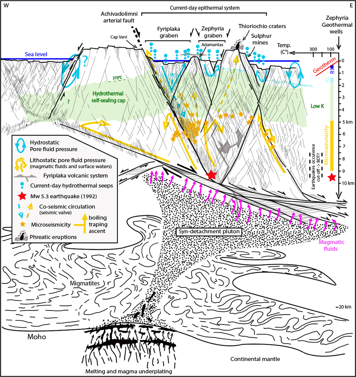
Synoptic cross-section showing the horst and graben architecture of the island of Milos along an E-W transect. The lower part of the section is stylized from the work of Jolivet et al. (2021), showing the crustal-scale relationship between plutons and normal faults in a stretching continental context. The current hydrothermal system is located exclusively in the hanging-wall (to the east) of the Achivadolimni fault. The 370 °C isotherm probably limits the self-sealed hydrothermal cap that could correspond to a local “thermal BDT” (Fournier, 1999) in which matrix and structural permeabilities are very low. This zone represents the lower limit of convective circulation in the faults and fractures of the first 2–3 kilometres under hydrostatic pore pressure (R1, shallow reservoir, R2 deep reservoir, Naden et al., 2005). Lenses of fluids (gases, magmatic waters, meteoric waters and brines) under lithostatic pore pressure are trapped beneath the very low permeability hydrothermal self-sealing cap. During a significant seismic rupture (> Mw 5.5?), the structural drains open up, allowing significant hydraulic communication between the reservoir under lithostatic pressure and the surface reservoirs. The result is sudden destabilization due to temperature rise and decompression of surface reservoirs, which can lead to phreatic eruptions such as those that created the historic Thiorychia craters (Langada area, Fig. 3). On the right of the figure is the average geothermal gradient, 250-300 °C/km, recorded in the 5 boreholes of the Zephyria Graben. The toponymy is projected onto the section. The distinctions between the different lithologies (e.g., basement, metamorphic basement, Miocene cover, Miocene-Pliocene volcanism, domes and flows, Fytikas et al. (1989)) have not been included to make the figure easier to read. In the geophysical sense, the brittle-ductile transition (BDT) is defined as the depth above which most earthquake hypocentres are located (Maggini and Caputo, 2021). It has also been reported on the figure.
Schéma synoptique montrant l’architecture en horst et graben de l’île de Milos suivant un transect E-W. La partie inférieure de la coupe est stylisée à partir des travaux de Jolivet et al. (2021), montrant la relation à l’échelle de la croute entre les plutons et les failles normales en contexte d’étirement. Le système hydrothermal actuel se situe exclusivement dans le bloc de toit (à l’est) de la faille de Achivadolimni. L’isotherme 370 °C limite probablement le « hydrothermal self-sealed cap » pouvant correspondre localement à la « brittle-ductile transition zone » au sens thermique du terme (Fournier, 1999) dans laquelle les perméabilités matricielle et structurale sont très faibles. Cette zone limite par le bas une circulation convective dans les failles et fractures des 2-3 premiers kilomètres sous pression de pore hydrostatique. Sous le « hydrothermal self-sealed cap » de très faible perméabilité, sont piégés des lentilles de fluides (gaz, eaux magmatiques, météoriques et saumures magmatiques) sous pression de pore lithostatique. La dilation de ces fluides par décompression et refroidissement, notamment à l’aplomb du golfe de Milos, génère probablement la micro-sismicité dans les core-zones et damage zones de la faille artérielle de Achivadolimni. Au cours d’une rupture sismique significative (> Mw 5.5 ?), les drains structuraux s’ouvrent, autorisent une communication hydraulique significative entre le réservoir sous pression lithostatique et les réservoirs superficiels. Il en résulte une déstabilisation soudaine par élévation de température et décompression des réservoirs superficiels pouvant engendrer des éruptions phréatiques, telles que celles à l’origine des cratères historiques de Thiorychia (Langada area, Fig. 3). A droite de la figure, le gradient géothermique moyen, 300 °C / km, compilé dans les 5 puits du graben de Zephyria, est figuré. La toponymie est projetée sur la coupe. Les distinctions entre les différentes lithologies (e.g., socle, socle métamorphique, couverture Miocène, volcanisme mio-pliocène, dômes et coulées, Fytikas et al. (1989)) n’ont pas été reportées pour faciliter la lecture de la figure. La Brittle-Ductile Transition (BDT) au sens géophysique est définie comme la profondeur au-dessus de laquelle l’essentiel des hypocentres de séismes est localisé (Maggini and Caputo, 2021). Elle est également indiquée sur la figure.
Current usage metrics show cumulative count of Article Views (full-text article views including HTML views, PDF and ePub downloads, according to the available data) and Abstracts Views on Vision4Press platform.
Data correspond to usage on the plateform after 2015. The current usage metrics is available 48-96 hours after online publication and is updated daily on week days.
Initial download of the metrics may take a while.