")
")
Fig. 4
Download original image
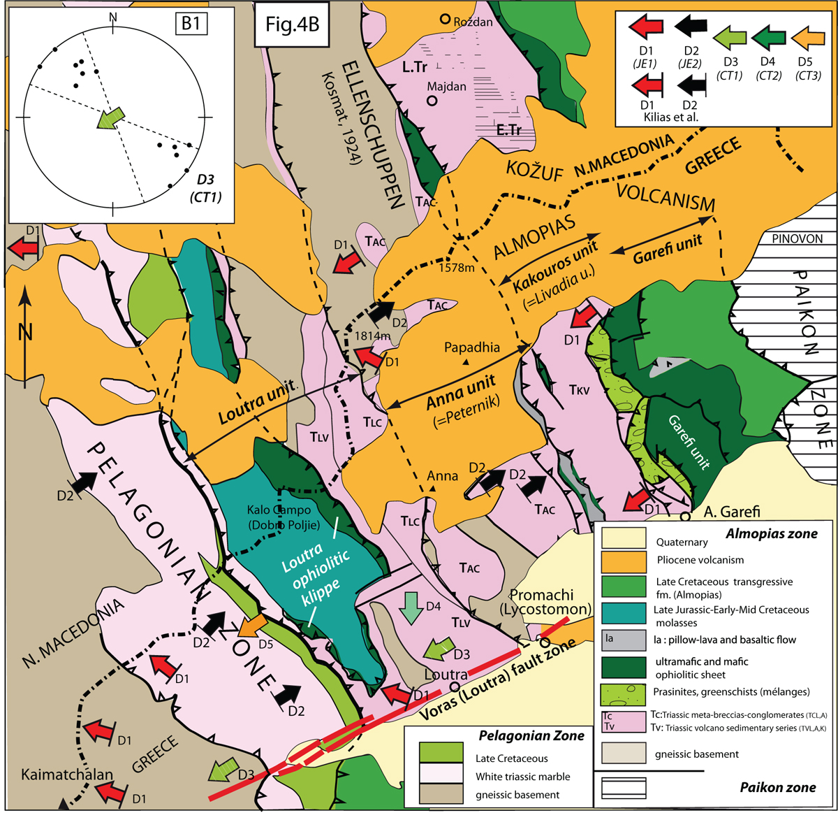
(A) Geological sketch of the Almopias zone in the Voras Mts (north of the Aridhea Plain). Same symbols as on Figure 4B. Stereonet B1: fold axes in the volcaniclastic series of the Loutra unit (TLv) (D3 event). Barred arrows are data from Kilias et al. (2010). The Palaeozoic basement of the Pelagonian Massif (Fig. 4A) is intruded by Late Carboniferous-Early Permian granites (≈285–300 Ma) (Yarwood and Aftalion, 1976; Mountrakis, 1986; Anders et al., 2005). The Almopias basin opened as a graben in a gneissic Pelagonian basement overlain by meta-volcanoclastic series (Tv) and meta-breccia-conglomerates (Tc), in the Loutra (L), Anna (A) and Koukourous (K) units. Subsequently, a klippe of harzburgites thrusts the meta-sedimentary fomation (Loutra unit) top-to-the-W. Harzburgites are covered by laterites and unconformably overlain by a transgressive molassic formation with conglomerates re-working ophiolitic and white marble pebbles, interbedded with limestones of Oxfordian-Tithonian age (Mountrakis, 1982) that confirm the Latest Jurassic age of the ophiolite obduction upon the Pelagonian margin. In the Koukourous unit, the meta-sedimentary and conglomeratic deposits are overlain by an Early Triassic Porphyrite-Radiolarite series covered by Lower Anisian limestones and a thick (≈1500 m) White Marble fm. of Late Anisian-Ladinian to Norian age. The Garefi Massif is a thick (≈1500 m) pile of harzburgite mantle tectonites with minor dunites, intruded by diabase dykes of MORB transitional to WPB affinity (Migiros and Galeos, 1990; Brown and Robertson, 2004; Saccani et al., 2015), with at the top a paleo-morphological surface overlain by lavas of WPB affinity. The Garefi ophiolites and the serpentinite sole of the Kakourous unit were weathered, covered by laterites and transgressively overlain by ophiolitic conglomerates and by limestones of Upper Albian-Upper Senonian age indicating deep erosion prior to their westward thrust (Mercier, 1968a). (B) Geological sketch of the Almopias zone, south of the Aridhea (Almopias) Plain. In stereonets A1, A2, A5, A7, A9, filled circles are: B1 fold axes, open circles: B2 fold axes; ster. A3 a: poles of brittle structures in the prasinitic tectonic mélange (filled circles: shear joints, open triangles: tension gashes: stars: fold axial planes; arrows: fold axes; ster. A3 b: poles of faults in the prasinitic mélange (filled circles: fault with normal component, open: with reverse component); ster. A4, thick punctuated lines: tension gashes on dextral relay zone striking N150°E; ster. A8, thick grey lines: granophyric and granitic dykes; ster. A10: poles of (S1) schistosity (D3 event) refolded by a B2 folds of the D4 event; ster. A11: folds axes (B1=N 12°E) and (B2=N77°E) in the Nea Zoi unit. Sites in squares on Figs.: A1: Rizarion, A2: Messimeri, A3: Edhessa mélange, A4: Klissochori, A5: Edhessa Station, A6: Grammatikon, A7: Kedronas, A8: Akrania, A9: western Paikon boundary, A10: Klissochori prasinites, A11: Nea Zoi. Sketch drawn from the Arnissa and Edhessa geological sheet (Mercier et al., 1984, 1987).
Current usage metrics show cumulative count of Article Views (full-text article views including HTML views, PDF and ePub downloads, according to the available data) and Abstracts Views on Vision4Press platform.
Data correspond to usage on the plateform after 2015. The current usage metrics is available 48-96 hours after online publication and is updated daily on week days.
Initial download of the metrics may take a while.