")
")
| Issue |
BSGF - Earth Sci. Bull.
Volume 196, 2025
|
|
|---|---|---|
| Article Number | 12 | |
| Number of page(s) | 27 | |
| DOI | https://doi.org/10.1051/bsgf/2025013 | |
| Published online | 20 June 2025 | |
Structural control of the hydrothermal system of the North-East Pyrénées (Corbières): Geothermal implications
Contrôle structural du système hydrothermal des Corbières (rétrobassin d’avant-pays oriental des Pyrénées) : implications géothermiques
1
Laboratoire Environnements et Paléoenvironnements Océaniques et Continentaux (EPOC), Université de Bordeaux, CNRS, Bordeaux INP, EPOC, UMR 5805, 33600 Pessac, France
2
Laboratoire Géosciences Montpellier (GM), Université de Montpellier, UMR 5243, Campus Triolet, CC060, Place Eugène Bataillon, 34095 Montpellier CEDEX 05, France
3
Laboratoire Morphodynamique Continentale et Côtière (M2C), Université de Caen, UMR 6143, 24 rue des tilleuls, 14032 Caen CEDEX 05, France
* Corresponding author: This email address is being protected from spambots. You need JavaScript enabled to view it.
Received:
3
September
2024
Accepted:
21
April
2025
Abstract
We investigate the hydrothermal system located at the North of the Pyrenean front forming a low relief area in a sedimentary environment (from the Mouthoumet Massif to the Montagne d’Alaric, Eastern-Pyrénées). This region is structured by W-E oriented Pyrenean folds and thrusts, which are affected by a dense network of NE-SW oriented fault system along which 24 hydrothermal springs localizes (>15 °C). Thanks to the construction of three balanced cross-sections and field-work campaigns, we infer that the structures abovementioned govern the hydrothermal system for the following reasons: 1) the Devonian carbonate layer confined between phyllosilicate rich formations constitutes the main fractured and karstified reservoir, 2) Pyrenean folds allows the main reservoir to outcrop at anticlines reliefs, favouring water recharge, flow at depth and high water column within low dipping limbs and synclines, 3) the Oligo-Miocene normal faults cut the fold and thrust structures and the phyllosilicate rich layers, and form dilatant high dipping pathways favoring the overpressured hydrothermal fluids to outflow at topographic depressions. The relatively low topography of the recharge area suggest that spring temperature is mainly controlled by reservoir depth, and therefore the folded and thrusted structure of the Devonian unit. This understanding of the reservoir geology and hydrothermal system provides new knowledge useful for geothermal exploration in polyphased-tectonics sedimentary environment.
Résumé
Nous explorons le système hydrothermal des Corbières situé au nord du front nord-pyrénéen en contexte orogénique de piémont sédimentaire (depuis le Massif de Mouthoumet jusqu’à la Montagne d’Alaric à l’est des Pyrénées). La région est structurée par les plis et chevauchements pyrénéens W-E, affectés d’un dense réseau de failles orientées NE-SW qui draine les fluides et localise 24 résurgences hydrothermales (>15 °C). Grâce à la construction de trois coupes équilibrées et de travaux de terrain, nous montrons que ces structures gouvernent les écoulements hydrothermaux pour les raisons suivantes : 1) les carbonates dévoniens, confinées entre les argiles siluriennes et les flyschs carbonifères, constituent le principal réservoir karstique et fracturé, 2) les plis pyrénéens favorisent sa recharge via sa mise à l’affleurement au niveau des anticlinaux, et les écoulements en profondeur via les flancs peu inclinées vers les synclinaux, 3) les failles normales oligo-miocènes NE-SW recoupent les plis, chevauchements et que les couches riches en phyllosilicates, et forment ainsi des conduits dilatants quasi-verticaux favorisant la surpression des fluides qui les empruntent pour atteindre les dépressions topographique. Les dénivelés relativement peu important entre la zone de recharge et les exutoires suggèrent que les températures des sources dépendent principalement de la profondeur atteinte par le réservoir dévonien déformé. La compréhension de la géologie du réservoir et de l’hydrosystème dans son ensemble offrent des nouvelles connaissances utiles pour l’exploration géothermique dans des zones sédimentaires déformées de manière polyphasée.
Key words: Pyrénées / Corbières / Mouthoumet Massif / geothermal system / faults and fluids / balanced cross-sections
Mots clés : Pyrénées, Corbières / Massif de Mouthoumet / système géothermal / failles et fluides / coupes équilibrées
© A. Eude et al., Published by EDP Sciences 2025
 This is an Open Access article distributed under the terms of the Creative Commons Attribution License (https://creativecommons.org/licenses/by/4.0), which permits unrestricted use, distribution, and reproduction in any medium, provided the original work is properly cited.
1 Introduction
In the context of the urgent energy transition to drastically reduce fossil energy production, mountain belts represent key areas for geothermal exploration (Moeck, 2014). In mountain belts and adjacent foreland basins, the main driving force for fluid flow, from a recharge to a discharge zone, is the topography (McKenna and Blackwell, 2004; Gallino et al., 2010; Toth, 2015; Taillefer et al., 2017, 2018; Sutherland et al., 2017). Surface waters from an elevated recharge area use any permeability conducts in rocks to flow downward. Permeability results from (1) connected matrix porosity in sedimentary rocks, (2) connected deformation discontinuities in rocks induced by stresses or fluid pressure (faults, fractures, dilation bands, porous cleavages), and (3) karstification, which are particularly pronounced in carbonate rocks. In a theoretical homogeneous hydrosystem environment, fluids follow Darcy’s law driving parabolic paths through the mount to the valley (Toth, 1978; 2015). In hydrothermal systems, waters flow at larger depth where they acquire their temperature and use fractured zones of enhanced permeability (Forster and Smith, 1989) to reach low topography area where pressure is low (McKenna and Blackwell, 2004; Taillefer et al., 2018). To understand hydrothermal systems, both rock composition and the geometry of sedimentary layers, networks of deformation discontinuities and karstification need to be studied (Evans et al., 1997; Thiébaud et al., 2010).
Fault zones play a crucial role in fluid flow within the Earth’s crust, as they concentrate deformation discontinuities that significantly impact permeability magnitude and anisotropy (Faulkner et al., 2010; Bernier et al., 2025; Evans et al., 1997). Their influence varies from acting as drains to barriers, depending on core zone fault rocks, damage zone discontinuities, and diagenesic processes (Bense et al., 2013; Toth, 2015; Keegan-Treloar et al., 2022). In the absence of clay gouge or juxtaposition seals (Knipe, 1997; Yielding et al., 1997), critically stressed faults facilitate vertical fluid migration, while inactive faults tend to be cemented over time (Barton et al., 1995; Bense et al., 2013). Fault dip angle is a key parameter, with steeper faults enhancing flow efficiency, making steep-angle strike-slip or normal faults more effective drains than low-angle thrust faults (Bense et al., 2013; Guillou-Frottier et al., 2020; Duwiquet et al., 2022). Studies in the Great Basin (USA) highlight preferential structural sites for geothermal upwellings, such as fault terminations, intersections, and bends (Faulds and Hinz, 2015; Siler, 2023). On a European scale, large crustal fault networks penetrating the entire continental crust are considered geothermal targets (Bellanger et al., 2019). In continental settings, deep faults facilitate both downward infiltration of meteoric water (e.g., Cévennes fault) and hydrothermal upwelling (e.g., Nîmes fault) (Garibaldi et al., 2010), leading to surface hydrothermal springs or blind geothermal systems where subsurface thermal anomalies occur without surface discharge (Duwiquet et al., 2022; Taillefer et al., 2024). The eastern French Pyrenees illustrate this phenomenon, with numerous hydrothermal springs exceeding 15 °C, particularly along the Têt Fault, where 29 springs are controlled by the footwall of its damage zone (Taillefer et al., 2017; 2018; 2021), capable of resetting U-Th-Sm/He thermo-chronometers in apatite (Milési et al., 2019; 2020; 2022). Hydrothermal springs are also observed along the Tech Fault, both faults being NE-SW normal structures affecting the Paleozoic basement of the Pyrenean Axial Zone and linked to the Late Oligocene–Early Miocene opening of the Gulf of Lion. These studies demonstrate that in mountain ranges, the interplay of topography, fault properties, and naturally fractured basement reservoirs generates strong geothermal anomalies. As summary, the understanding of the role of fault zones on hydrothermal system and geothermal anomalies has significantly increased recently. However, very few study describe the functioning of hydrothermal system in sedimentary fold and thrust belt, and the main controlling parameters of such systems (Moeck et al., 2014; Procesi et al., 2019). In particular, it remains unclear how the structures controls fluid recharge and hydrothermal flow in folded and faulted sedimentary reservoirs, and the relative contribution of topography, reservoir geometry and fault zones in such hydrothermal systems.
In this paper we present a study of the Corbières region, which is part of the retro-foreland basin of the Eastern Pyrénées where hydrothermal systems take place in a deformed sedimentary context. Despite its low-elevation (<1000 m), 24 hydrothermal springs from 15 to 46 °C exists around the Corbières‘s mounts. The Corbières region is affected by a polyphased deformation where faults are organized in two mains networks: W-E Pyrenean folds and thrusts, and a dense NE-SW normal fault network. It is therefore the appropriate place to examine the interaction between folds, thrusts, normal fault, and fluid flow in a deformed foreland basin. We focus our interest on the Devonian to Early Carboniferous (Mississipian) fractured/karstified carbonates series, which are described as the main geothermal reservoir of the region (Bouchaala, 1991; Elbaraka et al., 2010). We analyze the main structures and deduce their polyphased deformation through precise geological maps, three balanced cross-sections oriented NW-SE and microtectonics analyses from field. Together with reservoir geology knowledge and a review of hydrogeological data, this analysis allows inferring the functioning of the hydrothermal system.
2 Geological settings
2.1 General structure and history
The Corbières region corresponds to the Eastern Aquitaine basin, a shallower foreland basin than its western counterpart, separated by the Toulouse Fault (Angrand et al., 2018; Grool et al., 2018). It has experienced polyphased deformation from the Variscan Orogeny to the current seismicity. The variscan shortening was N-S to NW-SE with S-SE-vergent thrusting in the Mouthoumet Massif (solid dark grew lines in Figures 1 and 2; Bouchaala 1991; Bessière and Schulze 1984; Bessière et al., 1989; Berger et al., 1997; Soula et al., 2001; Christophoul et al., 2003), followed by post-Variscan collapse (310-270 Ma) characterized SE verging normal faults and strike-slip in the Montagne Noire (Arthaud and Matte, 1975; Van den Driessche and Brun, 1992; Fig. 1). The Mesozoic evolution of the region was marked by two main transtensional phases: a Triassic to Late Jurassic event (230-170 Ma) linking the Tethys and Atlantic oceans, and an Aptian to Cenomanian phase (125-93 Ma) that led to mantle exhumation and deep basin formation along the Pyrenean chain (Choukroune and Mattauer, 1978; Lemoine et al., 1986; Séranne et al., 1995; Bonijoly et al., 1996; Clerc et al., 2012; Ford et al., 2016; Ford and Vergès, 2020; Crémadès et al., 2021). In the Corbières region, strong thickness variations in the Mesozoic series (Fig. 3), influenced by normal faulting and salt weld development, indicate continuous extension and flexural subsidence, shaping the region’s structural inheritance from the Jurassic Tethysian margin and the Albo-Cenomanian rift (Laumonier et al., 1995; Clerc et al., 2016; Ford and Vergès, 2020; Crémadès et al., 2021).
The main structures of the Corbières region are dominated by N90°E to N110°E Pyrenean folds and thrusts due to horizontal shortening from 84 to 34 Ma (Roure et al., 1989; Choukroune, 1992; Muñoz, 1992; Vergès et al., 1995; Beaumont et al., 2000; Christophoul et al., 2003; Mouthereau et al., 2014; Ford et al., 2016; Grool et al., 2018). The Pyrenean belt represents the inversion of an Albo-Cenomanian transtensional margin during the Eurasian-Iberian collision (Choukroune and Mattauer, 1978; Baby et al., 1988; Ford and Vergès, 2020; Crémadès et al., 2021). It is divided into the Sub-Pyrenean Zone (SPZ) and the North Pyrenean Zone (NPZ), separated by the Northern Pyrenean Frontal Thrust (NPFT) (Fig. 1). The SPZ corresponds to the Albo-Cenomanian rifted margin, transitioning southward into the NPZ, which is itself delimited by the North Pyrenean Fault (NPF). Our study focuses on the SPZ north of the NPFT due to its hydrothermal systems, active NE-SW faulting, and proximity to the basement, favoring a higher geothermal gradient.
The transition between the Pyrenean contraction and Gulf of Lion extension is very fast and occurs during the Priabonian (Séranne et al., 1995; 2021, Goula et al., 1999; Milési et al., 2022). A dense NE-SW fault network develops, with some of them reactivating previously formed Variscan strike slips, and extends from the Eastern Pyrenees to Provence (Figs. 1 and 2) (e.g., Arthaud and Matte, 1975; Ellenberger et al., 1987; Séranne et al., 1995; 2021; Séranne, 1999). The N35°E to N70°E Cévennes, Nîmes and Têt faults (Cévennes Fault System, CFS, Ritz et al., 2021; Séranne et al., 2021; Milési et al., 2022) contrast with the N20°E to N35°E normal faults of the West European Rift, active during the Priabonian (Séranne et al., 2021; Milési et al., 2022). The CFS and Rift-related faults formed the Narbonne graben, Tournissan and Camplong Half-grabens, and Priabonian to Quaternary normal faults such as Têt, Capcir, Py, and Tech faults in the Axial Zone of the Pyrénées. Offshore, these structures align with the Oligo-Miocene Gulf of Lion opening (Fig. 1). In the SPZ, the NE-SW Chaînon de Lagrasse is truncated by the Oligo-Miocene Tournissan normal fault, verging SE (Ellenberger et al., 1987; Frizon de Lamotte, 2002).
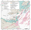 |
Fig. 1 Regional tectonics map with directions of horizontal deformations and paleostresses at different stages. Post-Variscan strike-slip motion in dark grey after Arthaud and Matte (1975); Matte (1986); Van den Dreissche and Brun (1992). Mesozoic Tethysian then Albo-Cenomanian rifting in blue arrows modified after Lemoine et al. (1986); Séranne et al. (1995); (2002); Bonijoly et al. (1996); Clerc and Lagabrielle (2014); Clerc et al. (2016); Ford and Vergès (2020); Crémadès et al. (2021). Pyrenean shortening directions in green after Arthaud and Séguret (1981); Arthaud and Laurent (1995); Séranne et al. (1995); Mascle et al. (1996); Lacombe and Jolivet (2005); Parizot et al. (2021; 2022). Oligo-Miocene extension, recent stress and deformation directions in orange arrows after Gorini et al. (1991, 1994); Séranne et al. (1995; 2002; 2021); Mascle et al. (1996); Goula et al. (1999); Séranne (1999); Mauffret et al. (2001); Rigo et al. (2015); Mazzotti et al. (2021); (Milési et al. 2020; 2022) and Parizot et al. (2021, 2022). Black dashed rectangle indicates the location of Figures 2 and 8. Geological data are extracted from the 1M-scale French Geological map (6th edition). The Gulf of Lion geometry is based on Séranne et al. (1995); Mauffret et al. (2001) and Jolivet et al. (2020). NPFT: Northern Pyrenean Frontal Thrust, NPF: Northern Pyrenean Fault. Hotsprings of the Pyrénées are extracted from BRGM maps and memoirs (see text for references) and Taillefer et al. (2018). |
 |
Fig. 2 a. Digital Elevation Model (SRTM 30m) with statistical mean direction of each faults network based on relative chronology (Pyrenean faults in green, mean direction N91.2°E; Post-Eocene faults in orange, N54.7°E) and the location hotsprings (>15 °C). b. Geological map of the Corbières region using chronostratigraphic chart (groups) described in Figures 3 and 4 after BRGM map (Bessière et al., 1977a; Souquet et al., 1984; Ellenberger et al., 1985; Crochet et al., 1989; Berger, 1990; Berger et al., 1993; 1997) and BRGM memoir (Bessière et al., 1977b; 1989; Ellenberger et al., 1987; Bilotte et al., 1988; Berger et al., 1990; 1993; 1997). Faults are colored by their last motion age (relative chronological mapping, field-work of this study and literature). Black dotted squares correspond to detailed geological maps of Figures 5–7. Hydrogeological mapping from BRGM books and memoirs (Pomerol and Ricour, 1992; Aunay and Le Strat, 2002; Elbaraka et al., 2010; Yvroux, 2012). Hotsprings are represented by triangles colored by temperatures and the boreholes pumping thermal waters are also indicated (Tab. 1). NCO : Nappe des Corbières Orientales. |
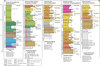 |
Fig. 3 North-South lithostratigraphic columns of the five studied synclines and their basement. Thicknesses are extracted from references mentioned below each column. Stratigraphic groups are initially defined by Ford et al., (2016) and then adapted by Rougier et al., (2016); Grool et al., (2018); Angrand et al., (2018); Ford and Vergès (2020); Crémadès et al., (2021) and this study for the Corbières region (see text for details). BRGM codes are reported for each formation. Series crossed by the Yvroux borehole of Rennes-les-Bains are indicated by a solid red line (and a dotted line when series are absent beneath the well location). Horizontal sinuous lines represent stratigraphic gaps (erosional surfaces). |
2.2 Stratigraphy
Paleozoic series in the Corbières region outcrop on the southern Montagne Noire flank, east of Montagne d’Alaric, and on the Mouthoumet Massif (Figs. 1–4) (Bessière et al., 1977, 1989; Ellenberger et al., 1987; Berger et al., 1990, 1993, 1997; Álvaro et al., 2016; Ford and Vergès, 2020; Crémadès et al., 2021). Middle Ordovician to Late Carboniferous layers are present in the SPZ. Ordovician-Silurian siltstones, marls, and shales serve as hydrogeological aquitard. Devonian fractured, karstic dolomites and limestones (300-600 m) outcrop at Montagne d’Alaric’s eastern end and the Mouthoumet Massif (Figs. 3 and 4). Carboniferous deposits overlay Devonian carbonates in the Montlaur syncline and Minervois basin, but discordantly in Talairan and Rennes-les-Bains synclines (Figs. 3 and 4). They consist of thin limestone layers (100 m) with increasing proportion of sand to the South. The Mouthoumet Massif preserves a 800 m-thick Carboniferous Variscan flysch, the top seal of the Devonian reservoirs (Elbaraka et al., 2010).
Mesozoic series reach 3000 m in the Saint-Paul-de-Fenouillet syncline (hanging wall of NPFT) (Chelalou et al., 2016; Ford and Vergès, 2020; Crémadès et al., 2021; Figs. 2 and 3). They are classified into Trias, Black Dolomite, Mirande, Pierrelys, Flysch, and Plantaurel groups (Ford et al., 2016; Rougier et al., 2016; Grool et al., 2018; Angrand et al., 2018; Crémadès et al., 2021; Figs. 2 and 3). Triassic evaporites (gypsum, Keuper formation) extend from this syncline to Rennes-les-Bains but are absent northward (Fig. 2). Beneath the eastern part of both hemi-grabens, diapiric Triassic sediments pierce the Eocene cover (Fig. 2). Jurassic Black Dolomite comprises karstic dolomites overlain by fault breccias (Chelalou et al., 2016). The Neocomian Mirande Group (400 m) consists of karstic limestones topped by Urgonian facies, unconformably overlain by Aptian Pierrelys limestones (Fig. 3). Albian flysch deposits relate to the Albo-Cenomanian rifting (Ford and Vergès, 2020). The Flysch group (∼1200 m) includes Upper Albian-Cenomanian and Turonian-Santonian marine deposits, significantly thinner in the SPZ than in the NPZ (Rougier et al., 2016; Ford and Vergès, 2020). Maastrichtian lacustrine limestones overlie Paleozoic basement (Figs. 2–4). The Rennes-les-Bains Flysch sequence features Early Cenomanian platform limestones, Turonian deltaic sandstones, and bioclastic limestones (Bilotte, 1985; Christophoul et al., 2003; Fig. 5). The Santonian Sougraigne marls marks the transition from deltaic to hemipelagic environments.
The Cenozoïc series are related to the Eastern Pyrenean retro-foreland developement through FS1 and FS2 tectonic phases (Tambareau et al., 1995; Christophoul et al., 2003; Ford et al., 2016), separated by Paleocene quiescence (Fig. 4). The Plantaurel group (Lower Campanian) includes 40-180 m of deltaic-fluvial Alet sandstones (Bilotte, 1985; Christophoul et al., 2003; Fig. 3). The Aude Valley group comprises Upper Campanian-Maastrichtian red marls, lacustrine limestones, and Lower Paleocene Vitrollian sandstones, deposited unconformably over Paleozoic substrates (Tambareau et al., 1995; Christophoul et al., 2003; Fig. 4). Cenozoic deposits are absent in the NPZ except near the Paziols fault’s NE-SW transition (Fig. 2). North of the NPFT, Cenozoic sediments appear around Rennes-le-Château and Rennes-les-Bains syncline (Fig. 2). The Rieubach group (Thanetian) in Montlaur, Talairan, and Couiza synclines consists of ∼400-500 m of red marls interbedded with lacustrine/palustrine limestones and molassic conglomerates (Figs. 2–4). These deposits originated from NPZ uplifts during FS1, while Montagne d’Alaric-derived clasts came from Montagne Noire (Christophoul et al., 2003; Al Reda et al., 2021). A Thanetian marine incursion occurred during FS2 (Tambareau et al., 1995; Christophoul et al., 2003). The Ypresian Coustouge group (300-400 m) features blue marls interbedded with lacustrine limestones, concluding with Oyster sandstones (Fig. 3). Growth strata indicate sedimentation during folding, especially at the Mouthoumet Massif front (Christophoul et al., 2003). For clarity, Rieubach and Coustouge groups are combined in figures. The Carcassonne group comprises FS2 molassic sediments (200-1000 m) with fluvial/lacustrine sandstones and conglomerates, notably thick near Montagne d’Alaric (Ellenberger et al., 1987; Berger et al., 1993; Christophoul et al., 2003; Al Reda et al., 2021). Oligo-Miocene half-grabens include breccia, fluvial/alluvial sandstones, and marine limestones (Ellenberger et al., 1987; Fig. 3). These deposits, observed on the NE-SW Paziols fault hanging wall (Fig. 2), are grouped as the Paziols formation (Ford and Vergès, 2020; Figs. 3 and 4).
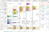 |
Fig. 4 North-South chronostratigraphic chart of the Corbières region used for mapping and cross-sections. Each tectonics event affected the Corbières region (Eastern Pyrénées) and along the proximal Cévennes Fault System (CFS) is presented with the main direction of deformation. Tectonic events have been colored using the same chart for faults in maps and cross-sections. Eocene and Miocene U-Pb calcite vein ages from Parizot et al., (2021). Hydrogeological aquifers were extracted from BRGM reports (Bouchaala, 1991; Pomerol and Ricour, 1992; Yvroux, 1994; Aunay and Le Strat, 2002; Elbaraka et al., 2010; Monod et al., 2016). |
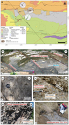 |
Fig. 5 a. Detailed geological map of Rennes-les-Bains (location in Fig. 2b) modified after Bessière et al. (1989) with microstructural analysis locations. The Arques NE-SW normal fault crosses the Cardou Thrust, which changing vergences, controls the Maastrichtian to Paleocene sedimentation. The Fontaine salée (ID 8) spring is also represented on the map. b. Nearly horizontal outcrop at the river bed RB2: Hotspring Bains de la Reine and NE-SW fracturation (cleavage) of the Coniacian series. c. Outcrop RB3: Joints into the Devonian series. d. Outcrop RB4: Thanetian conglomerates affected by N25 sinistral strike-slip displacement (post- ca., 55 Ma) along the Arques fault. e. Outcrop RB5: Breccia in Maastrichtian limestones along a N40 fault. f. The Fontaine salée spring: white color is induced by dissolved evaporites (Tab. 1). |
3 Hydrogeological settings
Hydrologically, 650 mm of rain falls each year in Alet-Les-Bains, twice as much (1200 mm/yr) in the town of Bouisse located on the heights of the Mouthoumet Massif (e.g., Aunay and Le Strat, 2002). All thermal springs have a calcium bicarbonate facies (Bouchaala, 1991).
3.1 Karstification
The main complexity of the hydrothermal system of the Corbières region is the karstic origin of the sedimentary aquifers (Valat, 1971; Kuhfuss, 1981; Bouchaala, 1991; Pomerol and Ricour, 1992; Aunay and Le Strat, 2002; Aunay et al., 2003; Elbaraka et al., 2010; Yvroux, 2012). Karstic formations containing groundwaters are presented in the Figures 3 and 4. Combining global eustatic curves and studies on tectonic uplift and subsidence of the Corbières region, Aunay and Le Strat, (2002) proposed the following theorical karstification potential: +125 m related to the Apto-Cenomanian rifting (mineralized Fe, Al karsts), +125 m Campanian FS1 (80 Ma) period of uplift and eustatic low-level, +120/80 m related to the Paleocene eustatic low-levels, +90 m Ypresian FS2 (50 Ma) period of uplift and flexural subsidence, +100/120 m Priabonian FS2 (34 Ma) period with important uplift, Icehouse, +40/50 m Chattian (28-24 Ma) Gulf of Lion rifting (shouldering uplift), −50 m Tortonian (11-10 Ma) uplift, −1500 m Messinian salinity crisis (6 Ma), −120 m 18 ka Last glacial maximum. The main episode affecting the karstification of the Corbières region is the Messinian crisis (Aunay and Le Strat, 2002).
3.2 Rennes-les-Bains
To characterize the hydrothermal system of the Corbières region, we separate our studies into three key areas: the Rennes-les-Bains area (Fig. 5), the Alet-les-Bains graben (Fig. 6) and the Montagne d’Alaric (Fig. 7).
In Rennes-les-Bains, several hydrogeologists have concentrated their studies due to the highest temperatures of natural hotsprings in the Corbières region (Valat, 1971; Kuhfuss, 1981; Bouchaala, 1991; Yvroux, 1994; 2012; Elbaraka et al., 2010). Six of the 32 to 46 °C natural hotsprings are located near the Sals river bed (Figs. 2b and 5a and Tab. 1). Also note that a 1460 m deep borehole has been drilled to pump hydrothermal waters for a thermal resort (Yvroux, 1994; Figs. 3, 5a, 8, and 9). Geochemical, structural and marked technics have been used to describe this hydrothermal system (Valat, 1971; Bouchaala, 1991; Elbaraka et al., 2010). The main recharge area is located on the Alet branch of the Mouthoumet Massif (Fig. 8), where outcropping Devonian and Lower Carboniferous karstic carbonates are affected by numerous directions of fractures (Fig. 5). According to Bouchaala (1991) and Elbaraka et al. (2010), the main formation draining the groundwater flow are the Devonian and Lower Carboniferous karstic carbonates (Figs. 2–4), overlaid by Carboniferous marls and flyschs. These carbonates represent the geothermal reservoir (Figs. 4 and 8). Meteoric waters reach the geothermal reservoir directly using the karstic drains and the vertical fractures of the Paleozoic rocks (Valat, 1971; Kuhfuss, 1981; Bouchaala, 1991; Yvroux, 2012; Elbaraka et al., 2010). The thickness of the reservoir (ca. 300 to 600 m, Figs. 3 and 4) allows a hydrological continuity of deep aquifers despite the compartmentalized shapes of the Mouthoumet Massif, where a geometrical (structural) approach is difficult (Bouchaala, 1991; Elbaraka et al., 2010). This reservoir represents the deep stock of interest for the geothermal exploration (Bouchaala, 1991; Elbaraka et al., 2010). The Cenomanian to Coniacian carbonates and sandstones (Figs. 3 and 4) form colder upper reservoirs (approximately 13.5 °C, Elbaraka et al., 2010). The large hotsprings temperatures interval (Tab. 1) result from a mixing between waters coming from the main Devonian geothermal reservoir and the upper ones (Bouchaala, 1991; Elbaraka et al., 2010; Figs. 3, 4, 8, and 9). In Rennes-les-Bains, Valat (1971) has yet remarked that hydrothermal springs are located at the vicinity of the NE-SW normal Arques fault (Figs. 2, 5, and 9). Natural hot water upwellings were often mixed with shallower colder waters when they encountered uppers aquifers. The main problem of the Rennes-les-Bains area is the difference between the natural hydrothermal surface temperature (46 °C) and the 34 °C encountered at the bottom of the 1460 m deep Yvroux borehole into the Devonian reservoir (Yvroux, 1994; 2012). Determining the structural organization under Rennes-les-Bains could answer this question. To the SE of Rennes-les-Bains (Fig. 5), salted springs are located within the Keuper evaporite décollement level of the Fontaine salée Thrust front (Figs. 2 and 5).
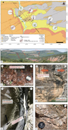 |
Fig. 6 a. Detailed geological map of the Alet-les-Bains graben (Western Mouthoumet Massif front) modified after Bessière et al. (1977a) with microtectonics analysis locations and hydrothermal springs. b. Interpreted Westward panorama of the Alet graben from the outcrop AB5. c. Outcrop AB7: karst cavities on the Devonian series NE-SW aligned. d. Outcrop Fa: sinistral strike-slip motion on the Fa fault. e. Outcrop Pu (location in Fig. 2b): Karstic corridor into the strike-slip Puivert fault affecting the Thanetian limestones (post- ca., 55 Ma). f. Outcrop AB7 picture of coarse calcite crystals of rhombohedral lamellar texture. Lamellar calcite is frequently described in epithermal systems and its texture is related to hot fluid overpressure (Simmons and Christenson, 1994; André-Mayer et al., 2002; Chauvet et al., 2006). |
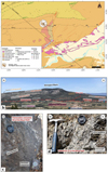 |
Fig. 7 a. Detailed geological map of the eastern termination of the Montagne d’Alaric, the Camplong Half-graben and the northern part of the Chaînon de Lagrasse modified after Ellenberger et al. (1987). Results of microtectonics analysis locations and field-work. b. Northward panorama of the Montagne d’Alaric from the Al1 point with a view on the NE-SW Graffan and Camplong faults and associated hotsprings. c. Outcrop Al2: Fracture and joints into the Devonian limestones affected by the Moux fault Damage Zone (DZ). d. Outcrop Al2: Cataclasite rock into the Devonian series affected by the Moux fault Core Zone (CZ). |
 |
Fig. 8 Field data map. Historical and instrumental earthquakes (Cara et al., 2015; Masson et al., 2021; Jomard et al., 2021). Focal mechanisms are extracted from the FMHex20 database (http://www.oreme.org; Mazzotti et al., 2021) associated with the Action Transverse Sismicité of the national research infrastructure Résif (https://www.resif.fr/). Hydrothermal mapping: sources are represented (Tab. 1) with their main recharge area, and deep hydrothermal flow into the Devonian reservoir is indicated by red arrows (from the Alet branch of the Mouthoumet Massif following the plunge of the Devonian Geothermal reservoir to the West and SW). Transects of the three serried balanced cross-sections are indicated by black lines (Figs. 9–11). Dip data are only represented on the Figure 2b to improve the readability of this map. |
 |
Fig. 9 Les Bains balanced cross-section and its Paleocene restoration (transect in Fig. 8). Paleozoic series thicknesses are extracted from the southern flank of the Montagne Noire and the Mouthoumet Massif. The Villerouge, Cardou and Boucher Thrusts are connected beneath the Mouthoumet Massif. The Fontaine salée Thrust is branched into the Triassic evaporites and brings a block of Carboniferous with a short-cut geometry. Hydrothermal waters mainly come laterally of the cross-section from the eastern Devonian series but an indicative 2D path is proposed (see cartographic groundwater flow in Fig. 8 and text for further details). Natural 46 °C springs come from the reservoir of the footwall of the Cardou thrust favor to NE-SW Arques fault, althougt the Yvroux borehole pumps the hangingwall shallower and colder 34 °C reservoir. In the restoration, the syn-orogenic serie thicknesses date the shortening during the FS2 phase. The origin of inherited faults is determined as Mesozoic or post-Variscan inherited transtensive (normal and/or strike-slip) faults or Variscan thrusts verging SW. Paleozoic series are considered flat when no data are available for the basement. Blue arrows represent Mesozoic normal displacement on NE-SW faults. Post-Eocene orange normal faults are connected to deep (12-25 km) events and interpreted with a sinistral strike-slip Eocene motion (FS2, colored in green). |
Hotsprings and associated boreholes of the Corbières region ordered by areas and valleys. Large temperature interval indicates mixing with upper colder waters during upward flow. The higher measured temperature of a spring is chosen to be represented on the maps because it is the most representative temperature of the reservoir when few mixing occurs. For each spring, chemical analysis is picked from BRGM memoirs indicated in the column References or from a document associated to the BSS code. Thermal waters of the Corbières region have homogeneous chemical compositions: calcium bicarbonated mineral water typically sourced from limestone-rich areas. The Fontaine salée spring, which rarely reaches 15 °C, is saturated by salt from the Triasic evaporites.
3.3 Alet-les-Bains
The Alet-les-Bains graben is delimited by the Puivert (connected to the NPFT to the west) and the Fa NE-SW normal and strike-slip faults (Figs. 2b and 6). Four natural hotsprings temperatures range between 25 and 32 °C, and are located close to these faults, which juxtapose the Devonian limestones with the Campanian Alet sandstones near the Aude Valley (Figs. 2 and 6). In Alet-les-Bains, Bouchaala (1991) described the same hydrogeological system than in Rennes-les-Bains. Meteoric waters came from the recharge area of the Mouthoumet Massif (Fig. 8), flow into the Devonian reservoir and reach the surface in the Aude valley river bed in the Alet sandstones (Aunay et al., 2003). A 344 m deep pumping well reaches the base of the Alet sandstones and extract water at 23 °C (Tab. 1, Fig. 6).
3.4 Montagne d’Alaric
East of the Montagne d’Alaric, five hotsprings (18-22,5 °C) are aligned along the NE-SW oriented Graffan fault (Ellenberger et al., 1987). In the Montagne d’Alaric area, the N-S oriented Moux fault East-verging (Figs. 2, 7, and 8) is connected to the Graffan and Camplong faults, aligned with the hotsprings (Fontcalel is with a constant debit of 30 L.s−1; Font intruse and Estagnol are two springs with 70 L.s−1 debits, Tab. 1). The 142 m deep borehole does not reach the Devonian reservoir (Ellenberger et al., 1987). The upper reservoirs of these hydrothermal springs are the Thanetian limestones (Ellenberger et al., 1987).
3.5 Isolated hotsprings
Several other hotsprings are present in the studied area (Tab. 1, Fig. 2). From West to East, two in the Quillan syncline (Ginoles, Tab. 1), two on the Alet branch of the Mouthoumet Massif, one around Soulatgé and two around Paziols (Figs. 2 and 8). In the Quillan syncline, on the hanging wall of the Pays de Sault Thrust, the Mesozoic pile reach 2000 m (Bessière et al., 1989; Crochet et al., 1989; Ford and Vergès, 2020). Groundwater flows occur in the complex multi-aquifers of the karstified Paleozoic and Mesozoic carbonates (Bilotte et al., 1988; Bardeau et al., 2015; Monod et al., 2016; Fig. 4). The 900 m Quillan borehole does not reach the Paleozoic basement, but Bardeau et al. (2015) and Monod et al. (2016) demonstrated a deeper thermal origin of groundwaters from the Devonian reservoir. Here, thermal waters flow into the Late Cretaceous karstic Cenomanian to Coniacian reservoir (Flysch group). The two springs of the Alet branch of the Mouthoumet Massif rarely reach 15 °C (Tab. 1). They result from the circulation into the Devonian karstic carbonates (Valat, 1971; Kuhfuss, 1981; Bouchaala, 1991; Berger et al., 1997; Elbaraka et al., 2010). They have important outflow due to their localizations on karstic caves exits compare to artesian hotsprings going up from fractured reservoir. Three hotsprings are located on the hanging wall of the Oligo-Miocene Paziols Half-graben south of the NE-SW Paziols post-Eocene faults, which cut the NPFT where it is bended (Fig. 2).
4 Methods
4.1 Microtectonic analysis of fault core and damage zones
Several field-work campaigns have been done to describe and measure faults and fractures in the damage (DZ) and core zones (CZ) around the three targeted spots with natural hydrothermal springs. For microtectonics analysis, we separate non-sealed mode I fractures, sealed mode I fractures (revealling paleo-fluid flow) and faults, which include reactivated fractures in shear and hybrid mode fractures. We measure the directions and plunge of these different types of structures. We finally analysed and measured slickenside to describe fault movements.
4.2 Balanced cross-sections and restorations
Three serried regional balanced cross-sections (Dahlstrom, 1969; Suppe, 1983; Suppe and Medwedeff, 1990) have been constructed from field subsurface data (transects and data shown in Fig. 8, sections in Figs. 9–11), and sismological data (projected historical and instrumental seismic events 5 km around transects and up to 34 km deep, Fig. 8), perpendicular to the NE-SW fault network, in order to understand the geometry and temporal relationship of the tectonic deformations and the implications for hydrothermal fluid flow. Cross-sections have been interpreted on the first 10 km of the crust but some faults are deeper, in direct relation with seismic events (Figs. 8–11). Restoration has been done using different classical technics in the construction of balanced cross-section reviewed in Moretti and Callot, (2012) (flexural slip, flexural flow, rotation blocks and surface area conservation). With an oblique (N140°E) direction to the Pyrenean shortening (ca. N175°E, Christophoul et al., 2003), contractional strain cannot be directly extracted. Nevertherless, restorations of cross-sections have been made at ca. 60 Ma, before the main Eocene FS2 Pyrenean shortening and the deduced minimum horizontal shortening projected is indicated. When projected on cross-sections, angles of the Pyrenean thrusts are reduced, except when Pyrenean shortening has a NW-SE direction, like the Chaînon de Lagrasse (Averbuch et al., 1992; Laumonier et al., 1995; Frizon de Lamotte et al., 2002) or the Nappe des Corbières Orientales (Viallard, 1987; Fig. 2).
5 Results
5.1 Microtectonics analysis around hydrothermal springs areas
5.1.1 Rennes-les-Bains area
In the Rennes-les-Bains area, from North to South, the verticalized N70E 70°N Paleocene series on the forelimb of the Cardou Thrust are affected by faults and fractures (outcrop RB1, Fig. 5a). The thrust fault zone has no clear slip surface to be measured but it is globally E-W, dipping about 45° South, and locally juxtaposes a lense of Maastritchian carbonates above the Vitrollian-Thanetian red silts and sandstones. In the Thanetian sandstones most of the fractures are N25E 30°E, although other low dipping (0° to 45°) fractures with various trends are also observed. The Devonian carbonates that are well present in the hanging wall are affected by an E-W trending network (N70 and N100) of conjugate en echelon veins consistent with normal fault initiation (outcrop RB3, Fig. 5c). Small and conjugate N-S trending normal faults also affect the Devonian series (Fig. 5c) and present the same orientation than a Variscan graben located to the West (Figs. 2 and 5a; Bessière et al., 1977b).
Near the cluster of hydrothermal springs of Rennes-les-Bains, the main fracture network affecting the Cretaceous cover is oriented NE-SW, close to the N55°E Arques fault (outcrop RB2, Fig. 5b, hotspring Bains de la Reine ID 4, Tab. 1). The warmest hotspring of Rennes-les-Bains (Bains forts ID 1, Tab. 1) are located on the Arques fault (Fig. 5a, red normal fault). The Arques fault crosses the Cardou Thrust and affects the series of the Rennes-les-Bains syncline with a NW vergence. To the north, on the footwall of the Cardou Thrust, the NE-SW Arques fault affects the series of the Couiza syncline with a normal component verging SE and shows post-Thanetian (ca. 55 Ma) low sinistral strike-slip component (outcrop RB4, Figs. 5a and 5c). Cataclastic rocks affecting the Maastrichtian limestones have been observed in the vicinity of a NNE-SSW oriented post-Eocene fault crossing the Cardou Thrust (outcrop RB5, Figs. 5a-e). The Fontaine salée spring (ID 8, SE limit of the map Fig. 5a and Tab. 1) comes out from the evaporitic Triassic series on the hanging wall of the Fontaine salée Thrust (Fig. 5f). Some Carboniferous blocks outcrop on the hanging wall of this thrust (Figs. 2b and 5a).
5.1.2 Alet-les-Bains area
The Alet-les-Bains graben is delimited by the Puivert and Fa NE-SW oriented normal fault network (Figs. 2 and 6a-b). To the SW, the Puivert and Fa faults clearly show post-Eocene normal displacement (Fig. 6a) but also strike-slip with sinistral movement (Figs. 6d and e, see the slickenside outcrops along the Puivert, mentioned Pu, and Fa faults, located in Figs. 2b and 6a). Numerous outcrops show that the Fa fault network has a sinistral strike-slip component affecting the Ypresian sediments (post-50 Ma, Fig. 6d and 6e). The Campanian to Thanetian series (Aude valley group) into the Alet graben are almost isopach, suggesting a post-Eocene normal faulting with a vertical shift of ca. 200 m on each fault (Fig. 6b). The Alet branch of the Mouthoumet Massif is affected by numerous Variscan NE-SW faults in line with NE-SW post-Eocene faults (Fig. 6a). Devonian rocks are affected by different directions of fractures. The main fracture directions are NE-SW (outcrops AB6, AB7), N-S (outcrop AB8) and NNE-SSW (outcrop AB7, Fig. 5a). Outcrops AB2 (Carboniferous schists) and AB3 (Campanian Alet sandstones) are affected by NE-SW faults and non-sealed fractures in the vicinity of the two NE-SW faults affecting the Basement and the Cenozoic cover of the Mouthoumet Massif, suggesting a post-Eocene age of reactivated Variscan faults. The Campanian Alet Sandstones are fractured (Fig. 6a) sometimes with preferential orientations (N-S, outcrop AB9) and with no clear orientation in other places (AB3, AB5). Along the Fa fault network (Fig. 6a), the Devonian carbonates, which are quite homogeneous in lithology (Fig. 4), seems to be gradually altered (Fig. 6b). From the NE to the SW, the dolostones change from a grey-red color to fully red color (Fig. 6b). The white color is anthropic dolomitic sands from the quarry. Also note that rhombohedral lamellar calcite is also observed into fractures affecting the Devonian carbonates close to the Fa fault (AB7, Fig. 6f).
The Aletex borehole (ID 13, Fig. 6a, Tab. 1) pumps, at 344 m, waters at 23 °C. The hotsprings of Alet-les-Bains are located on the Aude River bed, near the NE-SW Puivert and Fa faults, which juxtapose the Devonian carbonates to the Campanian Alet Sandstones (Fig. 6a). Near the warmest hotspring of Alet-les-Bains (33 °C, ID 9), the outcrop AB7 of altered Devonian carbonates reveals NE-SW oriented karstic caves, suggesting a preferential orientation of karstification along the NE-SW faults (Fig. 6c).
5.1.3 Montagne d’Alaric area
The Montagne d’Alaric is truncated by the connected N-S Moux, the NE-SW Graffan and the ENE-WSW Camplong faults verging respectively E, SE and S (Figs. 7a and 7b) with a minimum vertical offset of ca. 600 m (Ellenberger et al., 1987). The Camplong and Graffan faults localize the hot springs at their vicinity, but they do not outcrop enough to study their structure. They however cut the same Tertiary sediments of the Coustouge and Paziols groups than the Moux fault, which better outcrops. This Moux fault juxtaposes the Devonian carbonates and the Paleocene series (Figs. 7a and 7b). It affects the Devonian limestones as a multi-core fault zone containing protocataclasite and cataclasite (outcrop Al2, Figs. 7a, 7c and 7d). In the vicinity of the Core Zone, the Moux fault presents NE-SW sealed and non-sealed fractures with associated sinistral strike-slip displacements marked by calcite veins, but also conjugated NW-SE and NE-SW non-sealed fractures (outcrop Al2, Fig. 7d). The two artesian hotsprings named Font intruse (23 °C, ID 14) and Estagnol (22 °C, ID 16) are located on the Graffan fault (Fig. 7a), at the contact between Oligo-Miocene Paziols group rocks and folded Paleocene series (Coustouge group). The two hotsprings Garrigue plaine (21 °C, ID 17) and Pont Eaux-chaudes (20 °C, ID 18) seems to be located close to the southern end of the Graffan fault (Figs. 7a and 7b).
5.2 Balanced cross sections and restorations
5.2.1 Pyrenean structures
In Figure 9, the Les Bains balanced cross-section passes through the Alet-les-Bains and Rennes-les-Bains hydrothermal resorts. This cross-section reveals a thrusts system combining thin- and thick-skinned tectonics. Three basement N-verging thrusts forms the Boucher, Alet and Cardou anticlines. Growth strata affecting the Coustouge and Carcassonne groups above on the forelimbs of the Alet and Cardou branchs of the Mouthoumet Massif dates the deformation during the FS2 period. The Fontaine salée and the North Pyrenean Frontal Thrusts (NPFT) are branched on a décollement layer situated into the Triassic series inducing thin-skinned deformation (Fig. 9). However, along the Fontaine salée Thrust eastward, Carboniferous rocks outcrop (Figs. 2b and 5a). This short-cut geometry is allowed by Mesozoic normal faulting inversion (see restoration Fig. 9). Note that the geometry of the folded Devonian and Carboniferous series is drown using information from their along-strike geometry. The restorated Pyrenean deformation signal suggests Paleozoic folding favored by Variscan SE-verging thrusts. Without any geophysical data, the geometry of the Variscan deformation is difficult to constrain.
In the Carcassonne balanced cross-section (Fig. 10), the sedimentary cover implies ca. 1000 to 2500 m of Cenozoic deposits up to the Paleozoic basement. The basal unconformity of the Aquitaine basin reaches approximately 3 km towards NE. From the NW front to the SE, Montagne d’Alaric results from the formation of a fault propagation fold. The Alaric and Boucher Thrusts are connected into the basement, similarly than in the northeastward Lagrasse cross-section (Fig. 11). Growth strata marks the Ypresian (FS2) folding of the Mouthoumet Massif. The 28 km long Lagrasse cross-section and its restoration (Fig. 11) show the same combination of thin-skinned and thick-skinned tectonics, which are affecting the region. From the NW front of the Pyrénées to the SE, the Capendu, the Montagne d’Alaric and the Boucher anticlines were formed above three connected basement thrusts. On the deformed Eocene series of the forelimb of the Alaric anticline, oriented W-E, minor NE-SW oriented folds axes (Fig. 2) reveals NE-SW oriented blind thrusts such as the Capendu Thrust.
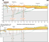 |
Fig. 10 Carcassonne balanced cross-section and its Paleocene restoration. Legend similar than the Figure 9. Alaric and Boucher Thrusts are connected into the basement. The restoration of syn-orogenic series shows the retro-foreland Eocene filling during shortening: the Villerouge Thrust activation is marked by growth strata deposit of the Coustouge group, then the Boucher and Alaric Thrusts during the Coustouge and Carcassonne group in agreement with the Les Bains cross-section. The NE-SW post-Eocene faults show slight vertical normal offsets. The numerous NE-SW post-Eocene faults affecting the hangingwall of the Boucher Thrust are in the alignment of Alet and Rennes-les-Bains. A part of the main recharge area (see Fig. 8) is indicated with a groundwater cold flow toward the W-SW. In the restoration, the NE-SW Mesozoic normal faults are considered with the same NE vergence than the post-Eocene displacement and similar to the NE-SW Mesozoic normal faults affecting the eastern part of the Mouthoumet Massif (see Figs. 2 or 8). |
5.2.2 NE-SW Faults
Post-Eocene normal faults are represented with orange lines and arrows (Figs. 2 and 8–11). The post-Eocene cumulative vertical offset of the NE-SW Puivert and Fa normal faults reaches 400 m in the Alet-les-Bains graben (Fig. 9), which is consistent with upper-crust scale faults (e.g., Cowie and Scholz, 1992; Perrin et al., 2016; Mayolle et al., 2019). Crossing the Pyrenean thrusts on the map, we also represent the post-Eocene NE-SW Arques fault, which cut the Villerouge and Cardou Thrusts with minor vertical displacements. However, note that this fault cuts the Arques basin tertiary rocks with larger displacement, more than hundred meters of normal displacement. These post-Eocene NE-SW faults therefore affect the Pyrenean folds and thrusts (Fig. 9). Regarding their length (>20 km), displacement and correlating these steep faults to deep seismic events allows us to draw them as faults cutting the deep basement rocks. Field-work observations and geological mapping analyses reveal that the Puivert and Fa NE-SW faults bounding the Alet-les-Bains graben are nearly aligned with the Camplong Half-graben and form a highly segmented fault zone at a larger scale (Figs. 2 and 8). The Chaînon de Lagrasse and relative Tournissan Half-graben is also aligned with the Rennes-les-Bains fault zone below which deep events occur (Figs. 8–11).
On the Carcassonne cross-section (Fig. 10), we suppose that post-Eocene faults reactivated Maastrichtian to Paleocene faults with the same post-Eocene vergence. In the Lagrasse cross-section (Fig. 11), the post-Eocene NE-SW faults cross the thrusts system with respectively 600 m in the Camplong and 500 m of vertical offset in the Tournissan Half-graben. Because of the presence of the N-S oriented salt weld (e.g., Ford and Vergès, 2020) and the circular salt diapir with Triassic evaporitic material just at the east of the cross-section, we suppose the presence of a Mesozoic sedimentary pile beneath the Cenozoic cover. The thickness of the Mesozoic series increases southeastward, favored by NE-SW Mesozoic normal faults (Fig. 11). The Chaînon de Lagrasse corresponds to a NE-SW oriented thin-skinned fold and thrust system (Figs. 2, 8, and 11) overprinted by the reactivation of the NE-SW Tournissan Fault. The Nappe des Corbières Orientales follows the same NW-SE shortening direction branching on the Triassic evaporites (e.g., Viallard, 1987; Crémadès et al., 2021).
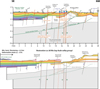 |
Fig. 11 Lagrasse balanced cross-section and its Paleocene restoration. Legend is the same than in Figure 9. The Capendu, Alaric and Boucher Thrusts are connected into the basement. The Capendu Thrust is interpreted as initiated on an inherited fault which would be active today. The Lagrasse Thrust is branched into the Triassic evaporites and affects the Mesozoic sedimentary cover. The NCO structure is not interpreted but the folded series beneath the flat ones may be due to the salt weld (Fig. 8). Post-Eocene NE-SW faults such as the Camplong and Tournissan networks are connected on deep (20-30 km) events and aligned along Alet and Rennes-les-Bains (Fig. 8). An indicative 2D hydrothermal path is proposed as an analogous of the Mouthoumet Massif one. In the restoration, numerous Mesozoic normal faults and other inherited faults are passively transported on the Thrusts and reactivated as post-Eocene faults after the folding. |
6 Discussion
6.1 Structure and tectonic history of the units hosting the hydrothermal system
6.1.1 Thin- and Thick-skinned tectonics during Pyrenean shortening
The thin-skinned Pyrenean inversion of Mesozoic normal faults is clearly demonstrated for the Pays de Sault Thrust, for the NPFT when it is oriented NE-SW (e.g., Clerc et al., 2016; Ford and Vergès, 2020; Crémadès et al., 2021), for the Lagrasse thrusts system and others Pyrenean structures to the NE (Saint-Chinian, Montpellier thrusts, Fig. 1). The Les Bains cross-section shows that the W-E oriented Fontaine salée Thrust results of an inversion of the Mesozoic margin (Fig. 9).
The syn-tectonics sedimentation shown on the cross-sections is consistent with results from Tambareau et al. (1995); Martin-Martin et al. (2001) and Christophoul et al. (2003). The W-E oriented Villerouge basement Thrust, which uplifted the Alet branch of the Mouthoumet Massif, does not seem to be a reactivation of any Mesozoic normal faults (Figs. 9–11). According to the northward thickening of the Mesozoic layers, the Cardou Thrust is initiated on a Late Cretaceous normal fault (Fig. 9). Moreover, the W-E oriented folds formed above the Villerouge and Alet thrusts have geometries similar to the Chester and Chester’s (1990) structural model involving reactivation of inherited ramps or fractured basement. The Paleozoic restoration geometry implies a Variscan S-verging shortening consistent with the results of Bessière and Schulze (1984); Bessière et al. (1989); Berger et al. (1997) and Soula et al. (2001). In this area, we proposed that the tectonic inheritance (Paleozoic and/or Mesozoic reactivation) allows the development of ramps, then forms fault propagation folds such as the Alet and Cardou branches of the Mouthoumet Massif. The Boucher anticline and syncline axes are oriented W-E and NE-SW by sectors (Figs. 2 and 8), suggesting that inherited basement NE-SW faults have been reactivated during shortening.
Bilotte (1978), Ellenberger et al. (1987) and Bilotte et al. (1988) have shown that the NE-SW Puivert, Fa and Rennes-le-Château faults partially control the Late Cretaceous to Paleocene filling from the Couiza syncline to the Pays de Sault towards SW, suggesting vertical motions along these faults during FS1 shortening stage. Moreover, in the Alet-les-Bains graben, the Puivert and Fa normal faults have been active after Maastrichtian and Paleocene times (Fig. 6). To the W, the Lavelanet and the eastward Puivert anticline axes are shifted by the Puivert fault with a lateral offset of 2 km, affecting Thanetian and Ypresian formations (Fig. 2), potentially suggesting that the Puivert fault worked as sinistral strike-slip tear fault during Pyrenean shortening, consistently with sinistral strike-slip slickenlines observed in the field (Figs. 6d and 6e). The NE-SW Puivert fault is connected to the NPFT westward (Figs. 1 and 2) where a focal mechanism (Bélesta event dated 1981; Rigo et al., 2015; Mazzotti et al., 2021) shows a NE-SW oriented sinistral strike-slip displacement (Figs. 2 and 8). With clear post-Eocene normal and sinistral strike-slip components, the Puivert and Fa faults show complex and polyphased displacements from the Late Eocene associated to FS2 shortening, followed by the Oligo-Miocene rifting phase. Approaching the Alet graben, the Puivert and Fa faults are organized in a complex network suggesting potentially large damage zones. Folds axes are also cut by post-Eocene faults suggesting sinistral strike-slip displacements during the FS2 phase followed by normal reactivations along them during the Oligo-Miocene rifting.
Tambareau et al. (1995) built a cross-section along the Aude valley where Pyrenean thrusts are connected to a 1.5 km deep and low-angle (< 5°) décollement layer. Christophoul et al. (2003) proposed a flat and ramp geometry with two décollement layers at 1.5 and 2.5 km. At the contrary, Clerc and Lagabrielle (2014), Clerc et al. (2016) and Ternois et al. (2019) proposed that the uplift of the Mouthoumet Massif results of a direct inversion of steep-angle normal faults affecting the basement inherited from the Mesozoic rift margins. On the rift platform, Ford and Vergès (2020) draw NE-SW oriented normal faults without Pyrenean inversion. Here we construct a combined model where Pyrenean thrusts are branched into the basement in areas where there are no Mesozoic sediments. Thin-skinned tectonics, with thrusts branched on the evaporitic Keuper formation, dominates in the areas of SPZ where Triassic and Jurassic series reach a sufficient thickness (ca. 1000 m). Thanks to a precise geological mapping and the construction of three balanced cross-sections, we show that W-E or NE-SW inherited faults are reactivated during Pyrenean FS2 shortening phase. In this study, we infer that the tectonic style of shortening reveals that the limit of the Triassic series is shifted ca. 5 km westward compare to previous interpretations proposed by Ford and Vergés (2020) or Crémadès et al. (2021). This study highlights the combination of thin- and thick-skinned tectonic style of the Corbières area depending on the Mesozoic inheritance.
6.1.2 Post-Eocene inheritance reactivation of NE-SW fault system
We interpret the NE-SW fault network as a steep-angle fault system affecting the Cenozoic, Mesozoic and the Paleozoic basement (Figs. 9–11). In Les Bains (Fig. 9), Carcassonne (Fig. 10) and Lagrasse (Fig. 11) cross-sections, the NE-SW faults are interpreted as tear faults with sinistral strike-slip displacement during the Pyrenean Late Cretaceous to Paleocene FS1, or Eocene FS2 shortening stages and were reactivated as normal faults during the Priabonian extension stage or the Oligo-Miocene Gulf of Lion opening. Restoration shows that most of these NE-SW faults were involved in the middle Cretaceous rifting structure and/or in the Maastrichtian to Paleocene filling during the FS1 flexural subsidence of the Eastern Aquitain basin.
Several observations allow us to propose that NE-SW inherited faults are steep-angle fault systems. First, the NE-SW faults are strait and aligned on the geological maps (Figs. 2 and 8). Secondly, in the western part of the Mouthoumet Massif, numerous NE-SW post-Eocene faults (Puivert, Fa, Brenac, Mayronnes and Arques faults) are directly connected or in the alignment of NE-SW Variscan strike-slip subvertical faults, suggesting a post-Eocene normal reactivation. Slight vertical reactivations of basement faults were actually invocated by the authors of the geological maps (Ellenberger et al., 1987; Bessière et al., 1989; Berger et al., 1997). In the eastern part of the Mouthoumet Massif, the Mesozoic NE-SW normal faults verging NW are in line with Variscan strike-slip faults reactivated during Pyrenean orogeny (Fig. 2). According to Ford and Vergès (2020), they were not reactivated although Berger et al. (1997) describe sinistral strike-slip component during the Pyrenean orogeny. In any case, it is an argument on the verticality of the NE-SW inherited faults. Thirdly, the NE-SW faults are passively transported along the green-drowned Pyrenean thrusts and reactivated after the Eocene as normal faults (Figs. 9–11). Finally, the NE-SW faults are vertically connected to deep events (Figs. 8–11). As previously noticed by the authors of the 1/50 000 scale geological maps (Ellenberger et al., 1987; Bessières et al., 1978; 1989; Berger et al., 1990; 1997), the NE-SW fault network that affects the Paleozoic basement, is partially reactivated during episodes of Mesozoic rifting, Pyrenean shortening and the Oligo-Miocene rifting.
At a larger scale (Fig. 1), it is clear that this fault system and its seismicity (Fig. 8) are aligned with the main trend of the lithospheric scale Cévennes master fault (CFS), and is therefore part of its widely distributed, south western tip damage zone, spanning from the Roussillon margin to the Minervois basin. Also note that strike-slip sinistral motion is observed along most of these NE-SW faults, suggesting that they are polyphased and not only formed by normal offset as observed in map. The NE-SW oriented CFS has a polyphased history and affects the Corbières region. From 16 My, the NE-SW oriented stress may induce slight motions on the NE-SW faults. The dense NE-SW fault system affecting the Corbières region follows a similar tectonics history than the CFS, suggesting that it is its horsetail termination favorable to geothermal upwellings (Faulds and Hinz, 2015).
6.2 The hydrothermal system
6.2.1 The main reservoir and pathways for hydrothermal waters
As mentioned in introduction, in folded and faulted sedimentary context, the identification of the reservoir unit, its geometry and deformation is determinant to understand the hydrothermal system. In the study area, the main geothermal reservoir is the fractured/karstified Devonian carbonates located between the Carboniferous schists/flysches and the Silurian marls (also see Bouchaala, 1991; Elbaraka et al., 2010). Waters emerge preferentially in the Devonian carbonates, they show evidences of hydrothermal flow, and they are karstic and fractured compare to sandstones and phyllosilicate rich layers lying above and below, acting as bottom and top seals. The other sedimentary series, excepted the Ypresian carbonates, are not aquifers and probably act as seals, especially when the phyllosilicate fraction is high (Figs. 3 and 4). The Devonian reservoir must be considered as a multiple porosity media including (1) matrix porosity of the altered dolomitic texture, (2) NE-SW normal faults and fracture porosity and (3) karst porosity. It therefore constitutes the storage but also the transfer capacity for hydrothermal fluids. Hydrothermal flows inferred from both spring location, structure of the reservoir at depth, reservoir outcrop in the reliefs, and by propositions from the literature, are indicated in the cross-section using blue (cold waters, recharge) and red (warm waters, discharge) arrows in Figures 9–11.
The Devonian reservoir layer form large parts of outcrops in the main reliefs of the Mouthoumet anticline, and it is located just below the surface (few hundred meters) in the main relief of the Alaric anticline (Figs. 9–11). Due to these anticlines, the Devonian carbonates are located in optimal conditions for the recharge and transfer of meteoric waters at depth along the limbs, hinges or fault zones. At emergences, the Devonian carbonates reach the surface at Alet-Les-Bains and is very close to the surface at Rennes-Les-Bains below the Flyshs, suggesting its important role to drive fluids in these main hydrothermal emergences.
A major point worth to consider, is that in most of the cases (Camplong, Alet-les-Bains, Rennes-les-Bains) fluid flow reach the surface into or adjacent to normal faults (Figs. 2, 5, 6, 8, 9, and 11). Faults and their related fracture damage zones are therefore macroscopic conducts for hydrothermal flow from or to the surface, but also into the Devonian reservoir. NE-SW faults generate strong anisotropy of permeability in reservoirs, especially in carbonate rocks because karstification better develops into fault damage zones (Fig. 6c) (e.g., Clauzon et al., 2020). Also worth to underline is that fault and their damage zones cut the phyllosilicate rich top seals unit lying above the Devonian and allow fluids to reach the surface in places where the Devonian reservoir does not outcrop. Although faults might be impermeable when cutting normally consolidated shales at shallow depth (e.g., Knipe, 1997; Yielding et al., 1997), phyllosilicate rich layers can be permeable if brittle when faulted (Ishii 2016; Fang et al., 2017). Brittleness of such lithology is acquired at a burial depth ranging between 1 and 3 kilometers and is referred to be due to mechanical (porosity loss, e.g., Mondol et al., 2007) and chemical compactions (illite-smectite transition, cementation, e.g., Laurent et al., 2012). This is obviously the case for the deeply buried hercynian Carboniferous series, which likely lost their integrity in places they are cut by the NE-SW trending normal faults and fractures. Permeability of fault damage zone is significantly enhanced during fault activity (e.g., Barton et al., 1995; Townend and Zoback, 2000), however fluid overpressure can also maintain fault and fracture opening through time without significant tectonic stress action (e.g., Sibson, 1977, 2000; Ligtenberg 2005). In the Corbières region, the absence of significant tectonic activity and seismicity close to the surface suggest that the tectonic activity and related stresses are not the main governing parameter along faults to maintain the observed fluid flow trough faults (Figs. 9–11). Seismic events occur at more than 10 km depth and hot fluids transferred into the Devonian reservoir outflowing in springs never reached this depth. We cannot exclude the contribution of seismicity to fluid flow, but at the timescale lower than the seismic cycle, other processes are more efficient. We therefore infer that water flows into the NE-SW faults as self-induced conducts due to dissolution into carbonate units, and water overpressure due to forced convection in the faulted-brittle phyllosilicate-rich units.
Finally, because both topography, lithology and structures vary laterally in the study area, each part of the hydrothermal system must be regarded as having specific geometry and juxtaposition of lithology. More details and specificity of fault geometry and layer structure of the Mouthoumet and Alaric hydrothermal systems are discussed below in section 6.2.3 and 6.2.4, after discussing the main parameters controlling water temperatures.
6.2.2 Main parameters controlling water temperature
According to both Bouchaala (1991) and Elbaraka et al. (2010), the water is of meteoric origin. In such geothermal systems waters acquire temperature at depth during downflow, and as mentioned above, they get emergence through permeable normal fault zones. The water pathway has to be permeable, due to connected matrix, fracture or karst porosity. The driving force of the fluid convection can result from two mechanisms, (1) free convection, due to heterogeneous water temperature, density and viscosity change, and (2) forced convection due to pressure difference triggered by variable water column below the relief. In both cases water has to keep enough temperature during ascension to reach the surface.
The role of depth into a water convection cell can be approximated according to Lowell (1975) using a simple relation between the emergence temperature (TE) and the water maximum depth of the cell (z). Considering a difference of elevation of △Z = 300 m between the springs and the outcrops of the Devonian carbonates at the top of the Mouthoumet massif, a water temperature at the recharge To = 10°, and a Peclet number α = 1 (according to Vasseur et al. (1997), meaning equal rates of advection and diffusion), we can discuss the depth (z) reached by the hydrothermal water observed at the surface (Fig. 12, Appendix A1). The temperature of the spring waters approximately ranges between 20 and 45 °C, and their temperature variation through time rarely exceeds 20%, and preferentially occurs for low temperatures measured (Tab. 1). We therefore consider a possible temperature underestimation of the hydrothermal water of a maximum of 20% as presented in Fig. 12. A depth z, ranging between 500 and 1500 m consistent with the topography elevations of the study area (Fig. 2a) is considered in Figure 12 as a function of water temperature.
Since the elevation and water mixing in the study area are not prominent, and also that temperatures are not severely affected by both variations of GE and GR in the range [0.02, 0.05], or variation of Peclet number of one order of magnitude; then the main controlling factor on water temperature measured at the surface is the maximum depth (z) of the water convection cell. In the study area, the depth of water convection is directly controlled by the structural geology, i.e., the depth of the reservoir layer (Devonian carbonate) and the location of the permeable faults (the NE-SW faults). In such sedimentary folded and faulted hydrotherml system, structural geology exerts a major role on fluid temperature, pathway and therefore geothermal anomaly.
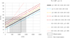 |
Fig. 12 Relationship between water temperature at emergence (TE) and recharge altitude (z) as a function difference of elevation between recharge altitude and emergence altitude (Dz) and vertical geothermal gradients at the recharge (GR) and emergence (GE). Dotted and grew square represent respectively the thermal groundwater mixed, and non-mixed, with cold surface waters. For example, the 46 °C springs of Rennes-Les-Bains can come from recharge areas located at 1000 (yellow) or 1500 (blue) m altitude provided that there is a difference in altitude of 600 or 1200m respectively. See Appendix 1 for further details. |
6.2.3 The Mouthoumet hydrothermal system
In the Mouthoumet Massif, the Devonian is at the surface over a large area. This area is an impluvium due to its large geographical relief over a large area at 500-900 m altitude, therefore favouring fluid recharge in the reservoir and transfer via forced convection. The folded geometry brings this Devonian to a depth of 2.5 km south of the Mouthoumet Massif near Rennes-les-Bains and laterally 2 km south of Alet-les-Bains. These maximum depths of the reservoir are from far large enough to obtain the temperatures measured at the surface (Fig. 12). The fluids reaching the surface did not actually reach these depths, as suggested by their SW verging downflow in the Devonian limb from the Mouthoumet top to the resurgences of Rennes and Alet-les-Bains following the main NE-SW fault trend (red arrows in Fig. 8). The phyllosilicate rich Silurian unit (Figs. 3 and 4), acting as bottom seal, is at a depth lower than 2 km along these fluid pathway, consistently with the temperature of the water observed at the surface lower than 50 °C.
In Rennes-les-Bains, resurgence is favoured by: (1) the presence of NE-SW faults connected to the Devonian towards the recharge zone, (2) within which forced convection can occur with significant pressures and temperatures in the deep Devonian, (3) the presence of a topographic trough in the Rennes valley, favouring low fluid pressure, and (4) the presence of marly Maastrichian and Palaeocene topseals (non-karst) to the west of the River. It is therefore likely that the fluids do not cross these top-seal units under the thrust but travel at depth in the Devonian basement and manage to cross the thrust at the level of the Variscan basement, which is also intersected by the NE-SW normal faults (red arrows in Fig. 9). The borehole exploits the waters of the reservoir at the hangingwall of the Cardou thrust (34 °C) while the waters of the reservoir at the footwall (46 °C) are drained to the surface by the NE-SW faults. Note that downward fluid transfer takes place in the NE-SW faults within the fractured Devonian and therefore almost perpendicular to the cross section.
At Alet-les-Bains, where temperatures are relatively low (23 − 32 °C), low depth (< 1 km) is enough to explain the temperatures measured at the surface. In this case, the upwelling fluids are more lateral to the Mouthoumet system, they are transferred from ENE to WSW from the Mouthoumet summit towards the emergence at Alet. It is highly likely that the water pathways through the Devonian reservoir were controlled by the damage zones of these faults (red NW arrow in Fig. 8). The hot fluids are certainly emerging at Alet because the Devonian reservoir is outcropping. It is intensely fractured and this zone is a topographic trough exactly below the top seal formed by the Tertiary sediments. The depths reached are shallow because the Devonian reservoir does not reach depths greater than 1 km where it meets the first normal fault zones (Fig. 9, North of the Brennac and Terroles faults). According to Figure 12 and considering that the hydrothermal waters are mixed with fresh waters, this depth of ∼1 km is relevant for the largest depth reached by the hydrothermal waters. In this case, the water first follow these NE-SW faults and then migrate towards the NW below the Aude valley to reach the surface at Alet, where the Devonien outcrops.
6.2.4 The Alaric hydrothermal system
In the Alaric hydrothermal system, spring temperatures are between 15 and 25 °C, therefore much lower than in the Mouthoumet system. The water probably infiltrate in the relief, where the Devonian carbonate reservoir is very close to the surface below the unconformity, and goes at low depth following the structure of this reservoir unit, which amplitude of deformation and depth is relatively low compared to the Mouthoumet structure. The low temperatures found in the springs are very consistent with both the low elevation (∼400 m in mean, vs. ∼700 m in the Mouthoumet Massif) of the recharge area and the low depth of the Devonian reservoir below the springs (∼1000 m depth, vs. 2500 m in the Mouthoumet system). The springs emerge along the normal faults present at the esatern side of the Alaric mountain, which therefore are the main vertical conducts up to the surface for the hydrothermal flow. As in the Mouthoumet Massif or elswhere in the Pyrenees (Taillefer et al., 2017 and Soliva and Eude, 2024) the main mechanism invoked for fluid transfer is forced convection. The water column underneath the Alaric Mountain is probably high enough to get overpressured fluid when they migrate within the Devonian reservoir below the valley, where water column are lower. The Camplong normal faults and their damage pattern cut the entire basin layers and drive fluids up to the surface. This system has lower convection cells than in the Mouthoumet system, consistently with the low spring temperature found. Another difference with the Mouthoumet system, is that the convection cell is completely lateral (to the East) with respect to the anticline, related to the high topographic gradient due to the large displacement of the Camplong fault zone. The Camplong fault zone behaves locally as juxtaposition seal for transverse flow (fault trap) due to its large fault throw allowing juxtaposition of the Devonian reservoir in the footwall against the Stephanian impermeable schists in the hangingwall (Fig. 11). This likely helps hydrothermal fluids to be restricted to the western border of the Camplong basin (Fig. 8). This Camplong fault zone however cuts and affects the integrity of the brittle Carboniferous topseal, allowing fluids to leak from the juxtaposition trap and flow up to the surface.
The others few hydrothermal springs of the study region (Fontaine Salée, Ginoles) are very far from both the Alaric and Mouthoumet systems and were not analysed in this study. They are described as having different reservoir than the cases reported in this paper (e.g., Bilotte et al., 1988; Bessière et al., 1989; Monod et al., 2016).
7 Conclusions
Based on geological mapping, microtectonics analysis, balanced cross-sections, reservoir geology knowledge and intergration of hydrogeology literature, we demonstrated that:
(1) The main reservoir for hydrothermal water storage and flow is the Devonian carbonates, located between bottom and top seal units, composed of naturally fractured and karstified reservoir. The water recharges in the reliefs (impluviums), in places where the reservoir outcrops, or is very close to the surface. The waters are transferred at depth due to water column height increased by the recharge, from the top of the anticlines (generally forming the reliefs) to the synclines, which are generally located beneath topographic depressions.
(2) The geometry of the North Pyrenean fold and thrust belt controls the thermal properties of the hydrothermal system, since it governs the elevation difference between the recharge and the maximum depth of the reservoir. The reservoir outcrops at the reliefs formed by the anticlines, and its maximum depth, which is a prominent parameter controlling maximum temperature and overpressure of the hydrothermal water, is governed by the geometry of the thrusted synclines.
(3) The NE-SW fault network represents the main vertical drains for hydrothermal upflows, and probably also guides water transfer into the reservoir due to permeability enhancement. Their location within or close to topographic depressions controls the location of fluid emergence. Their location in places they cut the reservoir in the anticline limbs also controls the maximum depth of the water reached (and then their temperature).
The NE-SW fault system is inherited from at least the Mesozoic, or maybe post-Variscan. It has been reactivated as sinistral strike-slip faults and thrusts during the Pyrenean events and as normal faults during the Oligocene-Miocene rifting. Miocene to present strike-slip reactivation, as a recent but moderate seismic activity, is also observed. We propose that the NE-SW fault network affecting the Corbières region is a horsetail termination of the Cevennes fault system. Although seismicity can help maintaining these faults permeable, its large depth suggest that at the timescale lower than the seismic cycle, processes like water overpressurisation and dissolution are probably more efficient to maintain these conducts continuously permeables. The NE-SW fault system is a crustal fault zone to target for geothermal exploration, especially in places it is adjacent to folds allowing hydrothermal reservoir to outcrop and be buried at depth. Based on a joint analysis of structural and hydrogeological data, this study demonstrates the powerful potential of orogenic prisms and crustal fault zone as geothermal plays adjacent to foreland basins. Next studies should focus on geophysical exploration, petrophysical properties acquisition, 3D hydrothermal flow modelling, and NE-SW fault dating to better characterize the reservoir geometry, properties and behaviour.
Acknowledgments
We thank Alice Frochot, Simon Lacombe and Mattis Grenier for their work at the beginning of the project (Bachelor’s degree internships). We thank Aimé Pelissier-Thanon for her work on the field and Simon Rodrigues for his help on geological mapping (Master’s degree interships). We also thank colleagues of the Résif program OSU OREME for the discussions and to give us precise locations of earthquakes and associated focal mechanism (Mickaël Bonnin and Clément Perrin). We thank P. Angrand and anonymous reviewer for their stimulating comments which allow the manuscript to be clarified. Authors declare no competing interest.
References
- Al Reda SM, Barbarand J, Gautheron C, Lasseur E, Loget N, Pinna‐Jamme, et al. 2021. Thermal record of the building of an orogen in the retro‐foreland basin: Insight from basement and detrital thermochronology in the eastern Pyrenees and the north Pyrenean basin (France). Basin Res 33: 2763–2791. https://doi.org/10.1111/bre.12583. [CrossRef] [Google Scholar]
- Álvaro J.J, Colmenar J, Monceret E, Pouclet A, Vizcaïno D, 2016. Late Ordovician (post-Sardic) rifting branches in the North Gondwanan Montagne Noire and Mouthoumet massifs of southern France. Tectonophysics 681: 111–123. https://doi.org/10.1016/j.tecto.2015.11.031 [CrossRef] [Google Scholar]
- Álvaro JJ, Vizcaïno D. 1998. Révision biostratigraphique du Cambrien moyen du versant méridional de la Montagne Noire (Languedoc, France). Bull Soc Geol Fr 169: 233–242. [Google Scholar]
- André-Mayer A-S., Leroy J, Bailly L, Chauvet A, Marcoux E, Grancea L, et al. 2002. Boiling and vertical mineralization zoning: a case study from the Apacheta low-sulfidation epithermal gold-silver deposit, southern Peru. Min Dep 37: 452–464. https://doi.org/10.1007/s00126-001-0247-2. [CrossRef] [Google Scholar]
- Angrand P, Ford M, Watts AB. 2018. Lateral variations in foreland flexure of a rifted continental margin: the aquitaine basin (SW France). Tectonics 37 : 430–449. https://doi.org/10.1002/2017TC004670. [CrossRef] [Google Scholar]
- Arthaud F, Laurent P. 1995. Contraintes, déformation et déplacement dans l’avant-pays Nord-pyrénéen du Languedoc méditerranéen. Geodinamica Acta 8 : 142–157. https://doi.org/10.1080/09853111.1995.11105386. [CrossRef] [Google Scholar]
- Arthaud F, Matte Ph. 1975. Les décrochements tardi-hercyniens du sud-ouest de l’Europe. Géométrie et essai de reconstitution des conditions de la déformation. Tectonophysics 25 : 139–171. https://doi.org/10.1016/0040-1951(75)90014-1. [CrossRef] [Google Scholar]
- Arthaud F, Seguret M. 1981. Les structures pyrénéennes du Languedoc et du Golfe du Lion (Sud de la France). Bull Soc Geol Fr S7-XXIII: 51–63. https://doi.org/10.2113/gssgfbull.S7-XXIII.1.51. [CrossRef] [Google Scholar]
- Aunay B, Le Strat P. 2002. Introduction à la Géologie du karst des Corbières (No. BRGM/RP-51595-FR), BRGM. Orléans : BRGM. [Google Scholar]
- Aunay B, Le Strat P, Yvroux M, Mangin A, Dörfliger N. 2003. Circulations hydrothermales dans la partie occidentale du Massif de Mouthoumet (Aude). Presented at the Circulations hydrothermales en terrains calcaires. 10ème journée technique du Comité national français de l’Association Internationale des Hydrogéologues. Carcassone, pp. 115–122. [Google Scholar]
- Averbuch O, Frizon de Lamotte D, Kissel C. 1992. Magnetic fabric as a structural indicator of the deformation path within a fold-thrust structure: a test case from the Corbières (NE Pyrenees, France). J Struc Geol 14: 461–474. https://doi.org/10.1016/0191-8141(92)90106-7. [CrossRef] [Google Scholar]
- Baby P, Crouzet G, Specht M, Déramond J, Bilotte M, Debroas E-J. 1988. Rôle des paléostructures Albo-Cénomaniennes dans la géométrie des chevauchements frontaux nord-Pyrénéens. C R de l’Académie des Sciences. Série II. Mechanics. Physics. Chemistry. Space sciences. Earth Sci 308: 307–313. [Google Scholar]
- Bardeau M, Monod B, Lamotte C, Ladouche B, Le Goff E, Maréchal J-C. 2015. État des connaissances géologiques et hydrogéologiques sur le Plateau de Sault (Aude - Ariège) (No. BRGM/RP-64209-FR). BRGM, Orléans.Bessière, G., Schulze, H., 1984. [Google Scholar]
- Bardeau M, Monod B, Lamotte C, Ladouche B, Le Goff E, Maréchal J-C. 2015. État des connaissances géologiques et hydrogéologiques sur le Plateau de Sault (Aude - Ariège) (No. BRGM/RP-64209-FR). BRGM, Orléans. [Google Scholar]
- Barton CA, Zoback MD, Moos D. 1995. Fluid flow along potentially active faults in crystalline rock. Geol 23: 683. https://doi.org/10.1130/0091-7613(1995)023<0683:FFAPAF>2.3.CO;2. [CrossRef] [Google Scholar]
- Beaumont C, Muñoz JA, Hamilton J, Fullsack P. 2000. Factors controlling the Alpine evolution of the central Pyrenees inferred from a comparison of observations and geodynamical models. J Geophys Res 105 : 8121–8145. https://doi.org/10.1029/1999JB900390. [CrossRef] [Google Scholar]
- Bellanger M, Hermant B, Galibert S, Auxiètre J-L. 2019. Fault-controlled hydrothermal system associated with major Crustal Fault Zone: future drilling target to assess the deep geothermal potential − The Sioule license project. European Geothermal Congress, Den Haag, Netherlands, p. 10. [Google Scholar]
- Bense VF, Gleeson T, Loveless SE, Bour O, Scibek J. 2013. Fault zone hydrogeology. Earth Sci Rev 127: 171–192. https://doi.org/10.1016/j.earscirev.2013.09.008. [CrossRef] [Google Scholar]
- Berger G-M. 1990. Carte géol. France (1/50 000). Feuille de Lézignan-Corbières (1038). Carte géol. France. [Google Scholar]
- Berger G-M., Alabouvette B, Bessière G, Bilotte M, Crochet B, Dubar M, et al. 1997a. Notice explicative de la feuille de Tuchan (1078), BRGM. ed, Carte géol. France. Orléans. [Google Scholar]
- Berger G-M., Bessière G, Bilotte M, Viallard P. 1997b. Carte géol. France (1/50 000). Feuille de Tuchan (1078). Carte géol. France. [Google Scholar]
- Berger G-M., Boyer F, Debat P, Demange M, Freytet P, Marchal J-P, et al. 1993a. Notice explicative de la feuille de Carcassonne (1037), BRGM. ed, Carte géol. France. Orléans. [Google Scholar]
- Berger G-M., Boyer F, Rey J. 1990. Notice explicative de la feuille de Lézignan-Corbières (1038), BRGM. ed, Carte géol. France. Orléans. [Google Scholar]
- Berger G-M., Debat P, Demange M, Issard H, Perrin M, Boyer F, et al. 1993b. Carte géol. France (1/50 000). Feuille de Carcassonne (1037). Carte géol. France. [Google Scholar]
- Bernier L, Soliva R, Roubinet D, Dominguez S, Mayolle S, Bulliard M, et al. 2025. Spatial distribution of permeability in carbonate fault damage zones. J Struct Geol 105371 https://doi.org/10.1016/j.jsg.2025.105371. [Google Scholar]
- Bessière G, Bilotte M, Crochet B, Peybernès B, Tambareau Y, Villatte J. 1989. Notice explicative de la feuille de Quillan (1077), BRGM. ed, Carte géol. France. Orléans. [Google Scholar]
- Bessière G, Lenguin M, Marchal J-P., Barruol J, Ovtracht A. 1977a. Notice explicative de la feuille de Limoux (1059), BRGM. ed, Carte géol. France. Orléans. [Google Scholar]
- Bessière G, Lenguin M, Marchal J-P., Barruol J, Ovtracht A. 1977b. Carte géol. France (1/50 000). Feuille de Limoux (1059). Carte géol. France. [Google Scholar]
- Bilotte M. 1985. Le Crétacé supérieur des plateformes est-pyrénéennes. Strata S. 25: 1–438. [Google Scholar]
- Bilotte M. 1978. Évolution sédimentaire et tectonique du bassin sous-pyrénéen a la fin du Crétacé à l’Est de la Garonne. Bull Soc Geol Fr S7-XX: 649–655. https://doi.org/10.2113/gssgfbull.S7-XX.5.649 [CrossRef] [Google Scholar]
- Bilotte M, Cosson J, Crochet B, Peybernès B, Roche J, Taillefer F, et al. 1988. Notice explicative de la Feuille de Lavelanet (1076), BRGM. ed, Carte géol. France. Orléans. [Google Scholar]
- Bonijoly D, Perrin J, Roure F, Bergerat F, Courel L, Elmi S, et al. 1996. The Ardèche palaeomargin of the South-East Basin of France: Mesozoic evolution of a part of the Tethyan continental margin (Géologie Profonde de la France programme). Mar Pet Geol 13: 607–623. https://doi.org/10.1016/0264-8172(95) 00075–5. [Google Scholar]
- Bouchaala A-E. 1991. Hydrogéologie d’aquifères karstiques profonds et relations avec le thermalisme: Exemple de la partie occidentale du massif de Mouthoumet (Aude, France) (PhD thesis). Université de Franche-Comté, Besançon. [Google Scholar]
- Cara M, Cansi Y, Schlupp A, Arroucau P, Béthoux N, Beucler E, et al. 2015. SI-Hex: a new catalogue of instrumental seismicity for metropolitan France. Bull Soc Geol Fr 186: 3–19. https://doi.org/10.2113/gssgfbull.186.1.3. [CrossRef] [Google Scholar]
- Chauvet A, Bailly L, André A-S., Monié P, Cassard D, Tajada FL, et al. 2006. Internal vein texture and vein evolution of the epithermal Shila-Paula district, southern Peru. Miner Deposita 41 : 387–410. https://doi.org/10.1007/s00126-006-0068-4. [CrossRef] [Google Scholar]
- Chelalou R, Nalpas T, Bousquet R, Prevost M, Lahfid A, Poujol M, et al. 2016. New sedimentological, structural and paleo-thermicity data in the Boucheville Basin (eastern North Pyrenean Zone, France). C R Geosci 348: 312–321. https://doi.org/10.1016/j.crte.2015.11.008. [CrossRef] [Google Scholar]
- Chester JS, Chester FM. 1990. Fault-propagation folds above thrusts with constant dip. J Struc Geol 12: 903–910. https://doi.org/10.1016/0191-8141(90)90063-5. [CrossRef] [Google Scholar]
- Choukroune P. 1992. Tectonic Evolution of the Pyrénées. Ann Rev E Panet Sci 20: 143–158. https://doi.org/10.1146/annurev.ea.20.050192.001043. [Google Scholar]
- Choukroune P, Mattauer M. 1978. Tectonique des plaques et Pyrénées: sur le fonctionnement de la faille transformante nord-pyrénéenne; comparaisons avec des modèles actuels. Bull Soc Geol Fr S7-XX: 689–700. https://doi.org/10.2113/gssgfbull.S7-XX.5.689. [CrossRef] [Google Scholar]
- Christophoul F, Soula J-C., Brusset S, Elibana B, Roddaz M, Bessiere G, et al. 2003. Time, place and mode of propagation of foreland basin systems as recorded by the sedimentary fill: examples of the Late Cretaceous and Eocene retro-foreland basins of the north-eastern Pyrenees. Geol Soc London Spe Pub 208: 229–252. https://doi.org/10.1144/GSL.SP.2003.208.01.11. [CrossRef] [Google Scholar]
- Clauzon V, Mayolle S, Leonardi V, Brunet P, Soliva R, Marchand P, et al. 2020. Fault zones in limestones: impact on karstogenesis and groundwater flow (Lez aquifer, southern France). Hydrogeol J 28: 2387–2408. [CrossRef] [Google Scholar]
- Clerc C, Lagabrielle Y. 2014. Thermal control on the modes of crustal thinning leading to mantle exhumation: Insights from the Cretaceous Pyrenean hot paleomargins. Tectonics 33 : 1340–1359. https://doi.org/10.1002/2013TC003471. [CrossRef] [Google Scholar]
- Clerc C, Lagabrielle Y, Labaume P, Ringenbach J-C., Vauchez A, Nalpas T, et al. 2016. Basement-Cover decoupling and progressive exhumation of metamorphic sediments at hot rifted margin. Insights from the Northeastern Pyrenean analog. Tectonophysics 686: 82–97. https://doi.org/10.1016/j.tecto.2016.07.022. [CrossRef] [Google Scholar]
- Clerc C, Lagabrielle Y, Neumaier M, Reynaud J-Y., De Saint Blanquat M. 2012. Exhumation of subcontinental mantle rocks: evidence from ultramafic-bearing clastic deposits nearby the Lherz peridotite body, French Pyrenees. Bull Soc Geol Fr 183: 443–459. https://doi.org/10.2113/gssgfbull.183.5. 443. [CrossRef] [Google Scholar]
- Cowie PA, Scholz CH. 1992. Displacement-length scaling relationship for faults: data synthesis and discussion. J Struc Geol 14: 1149–1156. https://doi.org/10.1016/0191-8141(92)90066-6. [CrossRef] [Google Scholar]
- Crémades A, Ford M, Charreau J. 2021. Evidence of decoupled deformation during Jurassic rifting and Cenozoic inversion phases in the salt-rich Corbières-Languedoc Transfer Zone (Pyreneo-Provençal orogen, France). BSGF − Earth Sci Bull 192: 37. https://doi.org/10.1051/bsgf/2021022. [CrossRef] [EDP Sciences] [Google Scholar]
- Crochet B, Villatte J, Tambareau Y, Bilotte M, Bousquet J-P., Kuhfuss A, et al. 1989. Carte géol. France (1/50 000). Feuille de Quillan (1077). [Google Scholar]
- Dahlstrom CDA. 1969. Balanced cross sections. Can J Earth Sci 6: 743–757. https://doi.org/10.1139/e69-069. [CrossRef] [Google Scholar]
- Duwiquet H, Magri F, Lopez S, Guillon T, Arbaret L, Bellanger M, et al. 2022. Tectonic regime as a control factor for crustal fault zone (CFZ) geothermal reservoir in an amagmatic system: a 3D dynamic numerical modeling approach. Nat Resour Res 31 : 3155–3172. https://doi.org/10.1007/s11053-022-10116-w. [CrossRef] [Google Scholar]
- Elbaraka M, Vigouroux P, Le Strat P. 2010. Ressource en eau thermale de la station de Rennes-les-Bains. Etats des lieux (Aude) (No. BRGM/RP-58623-FR). BRGM, Orléans. [Google Scholar]
- Ellenberger F, Freytet P, Plaziat J-C., Bessière G, Viallard P, Berger G-M, et al. 1987. Notice explicative de la feuille de Capendu (1060), BRGM. ed, Carte géol. France. Orléans. [Google Scholar]
- Ellenberger F, Plaziat J-C., Freytet P, Jaffrézo M, Charrière A, l’Homer A, et al. 1985. Carte géol. France (1/50 000). Feuille de Capendu (1060). [Google Scholar]
- Evans JP, Forster CB, Goddard JV. 1997. Permeability of fault-related rocks, and implications for hydraulic structure of fault zones. J Struc Geol 19: 1393–1404. https://doi.org/10.1016/S0191-8141(97)00057-6. [CrossRef] [Google Scholar]
- Fang Y, Elsworth D, Wang C, Ishibashi T, Fitts JP. 2017. Frictional stability‐permeability relationships for fractures in shales. JGR Solid Earth 122: 1760–1776. https://doi.org/10.1002/2016JB013435. [CrossRef] [Google Scholar]
- Faulds JE, Hinz NH. 2015. Favorable Tectonic and Structural Settings of Geothermal Systems in the Great Basin Region, Western USA: Proxies for Discovering Blind Geothermal Systems, in: Proceedings World Geothermal Congress 2015. World Geothermal Congress 2015, Melbourne, Australia, p. 6. [Google Scholar]
- Faulkner DR, Jackson CAL, Lunn RJ, Schlische RW, Shipton ZK, Wibberley CAJ, et al. 2010. A review of recent developments concerning the structure, mechanics and fluid flow properties of fault zones. J Struc Geol 32: 1557–1575. https://doi.org/10.1016/j.jsg.2010.06. 009. [CrossRef] [Google Scholar]
- Ford M, Hemmer L, Vacherat A, Gallagher K, Christophoul F. 2016. Retro-wedge foreland basin evolution along the ECORS line, eastern Pyrenees, France. J Geol Soc 173: 419–437. https://doi.org/10.1144/jgs2015-129. [CrossRef] [Google Scholar]
- Ford M, Vergés J. 2020. Evolution of a salt-rich transtensional rifted margin, eastern North Pyrenees, France. J Geol Soc 178: jgs2019–157. https://doi.org/10.1144/jgs2019-157. [Google Scholar]
- Forster C, Smith L. 1989. The influence of groundwater flow on thermal regimes in mountainous terrain: A model study. J Geophys Res 94 : 9439. https://doi.org/10.1029/JB094iB07p09439. [CrossRef] [Google Scholar]
- Frizon de Lamotte D, Souque C, Grelaud S, Robion P. 2002. Early record of tectonic magnetic fabric during inversion of a sedimentary basin Short review and examples from the Corbières transfer zone (France). Bull Soc Geol Fr 173: 461–469. https://doi.org/10.2113/173.5.461. [CrossRef] [Google Scholar]
- Gallino S, Dzikowski M, Josnin J-Y., Gasquet D. 2010. Characterization of the hydrogeological boundary separating two aquifers: a multi-disciplinary approach combining geological, geochemical and hydrodynamic data (Aix-les-Bains, France). Bull Soc Geol Fr 181 : 305–313. https://doi.org/10.2113/gssgfbull.181.4.305 [CrossRef] [Google Scholar]
- Garibaldi C, Guillou-Frottier L, Lardeaux J-M., Bonté D, Lopez S, Bouchot V, et al. 2010. Thermal anomalies and geological structures in the Provence basin: Implications for hydrothermal circulations at depth. Bull Soc Geol Fr 181: 363–376. https://doi.org/10.2113/gssgfbull.181.4.363. [CrossRef] [Google Scholar]
- Gorini C, Mauffret A, Guennoc P, Le Marrec A. 1994. Structure of the gulf of lions (Northwestern Mediterranean Sea): a review. In: Mascle A. ed. Hydrocarbon and petroleum geology of France Berlin, Heidelberg: Springer Berlin Heidelberg, pp. 223–243. https://doi.org/10.1007/978-3-642-78849-9_17. [CrossRef] [Google Scholar]
- Gorini C, Viallard P, Déramond J. 1991. Modèle d’inversion structurale négative: la tectonique extensive post-nappe du bassin de Narbonne-Sigean (Corbières, Sud de la France). C R Acad Sci 312: 1013–1019. [Google Scholar]
- Goula X, Olivera C, Fleta J, Grellet B, Lindo R, Rivera LA, et al. 1999. Present and recent stress regime in the eastern part of the Pyrenees. Tectonophysics 308: 487–502. https://doi.org/10.1016/S0040-1951(99)00120-1. [CrossRef] [Google Scholar]
- Grool AR, Ford M, Vergés J, Huismans RS, Christophoul F, Dielforder A. 2018. Insights into the crustal‐scale dynamics of a doubly vergent orogen from a quantitative analysis of its forelands: a case study of the eastern pyrenees. Tectonics 37: 450–476. https://doi.org/10.1002/2017TC004731. [CrossRef] [Google Scholar]
- Guillou-Frottier L, Duwiquet H, Launay G, Taillefer A, Roche V, Link G. 2020. On the morphology and amplitude of 2D and 3D thermal anomalies induced by buoyancy-driven flow within and around fault zones. Solid Earth 11: 1571–1595. https://doi.org/10.5194/se-11-1571-2020. [CrossRef] [Google Scholar]
- Ishii E. 2016. Far‐field stress dependency of the failure mode of damage‐zone fractures in fault zones: results from laboratory tests and field observations of siliceous mudstone. JGR Solid Earth 121: 70–91. https://doi.org/10.1002/2015JB012238. [CrossRef] [Google Scholar]
- Jolivet L, Romagny A, Gorini C, Maillard A, Thinon I, Couëffé R, et al. 2020. Fast dismantling of a mountain belt by mantle flow: Late-orogenic evolution of Pyrenees and Liguro-Provençal rifting. Tectonophysics 776: 228312. https://doi.org/10.1016/j.tecto.2019.228312. [CrossRef] [Google Scholar]
- Jomard H, Scotti O, Auclair S, Dominique P, Manchuel K, Sicilia D. 2021. The SISFRANCE database of historical seismicity. State of the art and perspectives. C R Geosci 353: 257–280. https://doi.org/10.5802/crgeos.91. [Google Scholar]
- Keegan-Treloar R, Irvine DJ, Solórzano-Rivas SC, Werner AD, Banks EW, Currell MJ. 2022. Fault-controlled springs: a review. Earth-Sci Rev 230: 104058. https://doi.org/10.1016/j.earscirev.2022.104058. [CrossRef] [Google Scholar]
- Knipe RJ. 1997. Juxtaposition and Seal Diagrams to Help Analyze. Fault Seals in Hydrocarbon Reservoirs. AAPG Bull 81 (1997). https://doi.org/10.1306/522B42DF-1727-11D7-8645000102C1865D. [Google Scholar]
- Kuhfuss A. 1981. Géologie et hydrogéologie des Corbières méridionnales − Région de Bugarach, Rouffiac-Les-Corbières (3rd cycle PhD thesis). Université Paul Sabatier Toulouse III, Toulouse. [Google Scholar]
- Lacombe O, Jolivet L. 2005. Structural and kinematic relationships between Corsica and the Pyrenees-Provence domain at the time of the Pyrenean orogeny. Tectonics 24. https://doi.org/10.1029/2004TC001673. [Google Scholar]
- Laumonier B, Marignac C, Gasquet D. 1995. Cinématique d’un front de chevauchement: l’avant-pays de la nappe des Corbières aux environs de Lagrasse (Aude, France). CR Acad Sci 321: 1195–1201. [Google Scholar]
- Laurent D, Gay A, Baudon C, Berndt C, Soliva R, Planke S, et al. 2012. High-resolution architecture of a polygonal fault interval inferred from geomodel applied to 3D seismic data from the Gjallar Ridge, Vøring Basin, Offshore Norway. Mar Geol 332–334 134–151. https://doi.org/10.1016/j.margeo.2012.07.016. [CrossRef] [Google Scholar]
- Lemoine M, Bas T, Arnaud-Vanneau A, Arnaud H, Dumont T, Gidon M, et al. 1986. The continental margin of the Mesozoic Tethys in the Western Alps. Mar Petrol Geol 3: 179–199. https://doi.org/10.1016/0264-8172(86)90044-9. [CrossRef] [Google Scholar]
- Ligtenberg JH. 2005. Detection of fluid migration pathways in seismic data: implications for fault seal analysis. Basin Res 17: 141–153. https://doi.org/10.1111/j.1365-2117.2005.00258.x. [CrossRef] [Google Scholar]
- Lowell RP. 1975. Circulation in fractures, hot springs, and convective heat transport on mid-ocean ridge crests. Geophys J Int 40: 351–365. https://doi.org/10.1111/j.1365-246X.1975.tb04137.x. [CrossRef] [Google Scholar]
- Martin‐Martin M, Rey J, Alcala‐Garcia FJ, Tosquella J, Deramond J, Lara‐Corona E, et al. 2001. Tectonic controls on the deposits of a foreland basin: an example from the Eocene Corbières-Minervois basin, France. Basin Res 13: 419–433. https://doi.org/10.1046/j.0950-091x.2001.00158.x. [CrossRef] [Google Scholar]
- Mascle A, Vially R, Deville E, Biju-Duval B, Roy JP. 1996. The petroleum evaluation of a tectonically complex area: The western margin of the Southeast Basin (France). Mar Petrol Geol 13: 941–961. https://doi.org/10.1016/S0264-8172(96)00041-4. [CrossRef] [Google Scholar]
- Masson F, Petit C, Mazzotti S. 2021. Special issue Comptes-Rendus Geosciences for the 100 yr of the BCSF “Seismicity in France.” C R Geosci 353: 1–4. https://doi.org/10.5802/crgeos.94. [Google Scholar]
- Matte P. 1986. Tectonics and plate tectonics model for the Variscan belt of Europe. Tectonophysics 126 : 329–374. https://doi.org/10.1016/0040-1951(86)90237-4. [CrossRef] [Google Scholar]
- Mauffret A, Durand de Grossouvre B, Tadeu Dos Reis A, Gorini C, Nercessian A. 2001. Structural geometry in the eastern Pyrenees and western Gulf of Lion (Western Mediterranean). J Struc Geol 23: 1701–1726. https://doi.org/10.1016/S0191-8141(01)00025-6. [CrossRef] [Google Scholar]
- Mayolle S, Soliva R, Caniven Y, Wibberley C, Ballas G, Milesi G, et al. 2019. Scaling of fault damage zones in carbonate rocks. J Struc Geol 124: 35–50. https://doi.org/10.1016/j.jsg.2019.03.007. [CrossRef] [Google Scholar]
- Mazzotti S, Aubagnac C, Bollinger L, Coca Oscanoa K, Delouis B, Do Paco D, et al. 2021. FMHex20: An earthquake focal mechanism database for seismotectonic analyses in metropolitan France and bordering regions. BSGF − Earth Sci Bull 192: 10. https://doi.org/10.1051/bsgf/2020049. [CrossRef] [EDP Sciences] [Google Scholar]
- McKenna JR, Blackwell DD. 2004. Numerical modeling of transient Basin and Range extensional geothermal systems. Geothermics 33: 457–476. https://doi.org/10.1016/j.geothermics.2003.10.001. [CrossRef] [Google Scholar]
- Milési G, Monié P, Münch P, Soliva R, Taillefer A, Bruguier O, et al. 2020. Tracking geothermal anomalies along a crustal fault using (U-Th)/He apatite thermochronology and rare-earth element (REE) analyses: the example of the Têt fault (Pyrenees, France). Solid Earth 11: 1747–1771. https://doi.org/10.5194/se-11-1747-2020. [CrossRef] [Google Scholar]
- Milesi G, Monié P, Soliva R, Münch P, Valla PG, Brichau S, et al. 2022. Deciphering the cenozoic exhumation history of the eastern pyrenees along a crustal‐scale normal fault using low‐temperature thermochronology. Tectonics 41. https://doi.org/10.1029/2021TC007172. [CrossRef] [Google Scholar]
- Milesi G, Soliva R, Monié P, Münch P, Bellanger M, Bruguier O, et al. 2019. Mapping a geothermal anomaly using apatite (U‐Th)/He thermochronology in the Têt fault damage zone, eastern Pyrenees, France. Terra Nova 31: 569–576. https://doi.org/10.1111/ter.12429. [CrossRef] [Google Scholar]
- Moeck IS. 2014. Catalog of geothermal play types based on geologic controls. Renew Sustain Energy Rev 37: 867–882. https://doi.org/10.1016/j.rser.2014.05.032. [CrossRef] [Google Scholar]
- Mondol NH, Bjørlykke K, Jahren J, Høeg K. 2007. Experimental mechanical compaction of clay mineral aggregates—Changes in physical properties of mudstones during burial. Marine Pet Geol 24: 289–311. https://doi.org/10.1016/j.marpetgeo.2007.03.006. [CrossRef] [Google Scholar]
- Monod B, Allanic C, Bailly-Comte V, Jacob T, Maréchal J-C. 2016. Évaluation des ressources en eaux souterraines du Plateau de Sault − étude structurale, modèle géoloique 3D, acquisition gravimétrique et analyse de la karstification (No. BRGM/RP-65888-FR), BRGM. BRGM, Orléans. [Google Scholar]
- Montmartin C, Faure M, Raimbourg H. 2021. Paleotemperature investigation of the Variscan southern external domain: the case of the Montagne Noire (France). BSGF − Earth Sci Bull 192: 3. https://doi.org/10.1051/bsgf/2020043. [CrossRef] [EDP Sciences] [Google Scholar]
- Moretti I, Callot JP. 2012. Area, length and thickness conservation: Dogma or reality? J Struc Geol 41: 64–75. https://doi.org/10.1016/j.jsg.2012.02.014. [CrossRef] [Google Scholar]
- Mouthereau F, Filleaudeau P-Y., Vacherat A, Pik R, Lacombe O, Fellin MG, et al. 2014. Placing limits to shortening evolution in the Pyrenees: Role of margin architecture and implications for the Iberia/Europe convergence: Plate convergence in the Pyrenees. Tectonics 33: 2283–2314. https://doi.org/10.1002/2014TC003663. [CrossRef] [Google Scholar]
- Muñoz JA. 1992. Evolution of a continental collision belt: ECORS-Pyrenees crustal balanced cross-section. In: McClay KR. ed. Thrust Tectonics. Dordrecht: Springer Netherlands, pp. 235–246. https://doi.org/10.1007/978-94-011-3066-0_21. [Google Scholar]
- Parizot O, Missenard Y, Barbarand J, Blaise T, Benedicto A, Haurine F, et al. 2022. How sensitive are intraplate inherited structures? Insight from the Cévennes Fault System (Languedoc, SE France). Geol Mag 159: 2082–2094. https://doi.org/10.1017/S0016756822000152. [CrossRef] [Google Scholar]
- Parizot O, Missenard Y, Haurine F, Blaise T, Barbarand J, Benedicto A, et al. 2021. When did the Pyrenean shortening end? Insight from U-Pb geochronology of syn‐faulting calcite (Corbières area, France). Terra Nova 33 : 551–559. https://doi.org/10.1111/ter.12547. [CrossRef] [Google Scholar]
- Perrin C, Manighetti I, Ampuero J, Cappa F, Gaudemer Y. 2016. Location of largest earthquake slip and fast rupture controlled by along-strike change in fault structural maturity due to fault growth. JGR Solid Earth 121: 3666–3685. https://doi.org/10.1002/2015JB012671. [CrossRef] [Google Scholar]
- Pomerol C, Ricour J. 1992. Terroir et thermalisme − Les eaux minérales françaises, BRGM. ed. Editions du BRGM. [Google Scholar]
- Procesi M, Ciotoli G, Mazzini A, Etiope G. 2019. Sediment-hosted geothermal systems: Review and first global mapping. Earth-Sci Rev 192: 529–544. https://doi.org/10.1016/j.earscirev.2019.03. 020. [CrossRef] [Google Scholar]
- Rigo A, Vernant P, Feigl KL, Goula X, Khazaradze G, Talaya J, et al. 2015. Present-day deformation of the Pyrenees revealed by GPS surveying and earthquake focal mechanisms until 2011. Geophy J Int 201: 947–964. https://doi.org/10.1093/gji/ggv052. [CrossRef] [Google Scholar]
- Ritz J-F., Baize S, Audin L, Authémayou C, Graveleau F, Kaub C, Lacan P, et al. 2021. New perspectives in studying active faults in metropolitan France: the “Active faults France” (FACT/ATS) research axis from the Resif-Epos consortium. C R Geosci 353: 381–412. https://doi.org/10.5802/crgeos.98. [Google Scholar]
- Rougier G, Ford M, Christophoul F, Bader A-G. 2016. Stratigraphic and tectonic studies in the central Aquitaine Basin, northern Pyrenees: Constraints on the subsidence and deformation history of a retro-foreland basin. C R Geosci 348 : 224–235. https://doi.org/10.1016/j.crte.2015.12.005. [CrossRef] [Google Scholar]
- Roure F, Choukroune P, Berastegui X, Munoz JA, Villien A, Matheron P, et al. 1989. Ecors deep seismic data and balanced cross sections: Geometric constraints on the evolution of the Pyrenees. Tectonics 8: 41–50. https://doi.org/10.1029/TC008i001p00041. [CrossRef] [Google Scholar]
- Séranne M. 1999. The Gulf of Lion continental margin (NW Mediterranean) revisited by IBS: an overview. Geol Soc, London, Spe Pub 156: 15–36. https://doi.org/10.1144/GSL.SP. 1999.156.01.03. [CrossRef] [Google Scholar]
- Séranne M, Benedicto A, Labaum P, Truffert C, Pascal G. 1995. Structural style and evolution of the Gulf of Lion Oligo-Miocene rifting: role of the Pyrenean orogeny. Mar Petrol Geol 12: 809–820. https://doi.org/10.1016/0264-8172(95)98849-Z. [CrossRef] [Google Scholar]
- Séranne M, Camus H, Lucazeau F, Barbarand J, Quinif Y. 2002. Polyphased uplift and erosion of the Cévennes (southern France). An example of slow morphogenesis. Bull Soc Geol Fr 173: 97–112. https://doi.org/10.2113/173.2.97. [CrossRef] [Google Scholar]
- Séranne M, Couëffé R, Husson E, Baral C, Villard J. 2021. The transition from Pyrenean shortening to Gulf of Lion rifting in Languedoc (South France) − A tectonic-sedimentation analysis. BSGF − Earth Sci Bull 192: 27. https://doi.org/10.1051/bsgf/2021017. [CrossRef] [EDP Sciences] [Google Scholar]
- Sibson RH. 2000. Fluid involvement in normal faulting. J Geodyn 29: 469–499. https://doi.org/10.1016/S0264-3707(99)00042-3. [CrossRef] [Google Scholar]
- Sibson RH. 1977. Fault rocks and fault mechanisms. J Geol Soc 133: 191–213. https://doi.org/10.1144/gsjgs.133.3.0191. [CrossRef] [Google Scholar]
- Siler DL. 2023. Structural discontinuities and their control on hydrothermal systems in the Great Basin, USA. Geoenergy 1, geoenergy 2023–009. https://doi.org/10.1144/geoenergy2023-009. [Google Scholar]
- Simmons SF, Christenson BW. 1994. Origins of calcite in a boiling geothermal system. Am J Sci 294: 361–400. https://doi.org/10.2475/ajs.294.3.361. [CrossRef] [Google Scholar]
- Soliva R, Eude A. 2024. Système hydrothermal et potentiel géothermique en contexte orogénique: L’exemple des Pyrénées. Géologues 221. [Google Scholar]
- Soula J-C., Debat P, Brusset S, Bessière G, Christophoul F, Déramond J. 2001. Thrust-related, diapiric, and extensional doming in a frontal orogenic wedge: example of the Montagne Noire, Southern French Hercynian Belt. J Struct Geol 23: 1677–1699. https://doi.org/10.1016/S0191-8141(01)00021-9. [CrossRef] [Google Scholar]
- Souquet P, Bilotte M, Peybernès B, Cosson J, Bousquet J-P., Ciszack R, et al. 1984. Carte géol. France (1/50 000). Feuille de Lavelanet (1076). Carte géol. France. [Google Scholar]
- Suppe J. 1983. Geometry and kinematics of fold-bend folding. Am J Sci 283: 684–721. https://doi.org/10.2475/ajs.283.7.684. [CrossRef] [Google Scholar]
- Suppe J, Medwedeff DA. 1990. Geometry and kinematics of fault-propagation folding. Eclog Geol Helvet 83: 409–454. [Google Scholar]
- Sutherland R, Townend J, Toy V, Upton P, Coussens J, Allen M, et al. 2017. Extreme hydrothermal conditions at an active plate-bounding fault. Nature 546: 137–140. https://doi.org/10.1038/nature22355. [CrossRef] [Google Scholar]
- Taillefer A, Guillou‐Frottier L, Soliva R, Magri F, Lopez S, Courrioux G, et al. 2018. Topographic and Faults Control of Hydrothermal Circulation Along Dormant Faults in an Orogen. Geochem Geophys Geosyst 19 : 4972–4995. https://doi.org/10.1029/2018GC007965. [CrossRef] [Google Scholar]
- Taillefer A, Milesi G, Soliva R, Monnier L, Delorme P, Guillou-Frottier L, et al. 2021. Polyphased brittle deformation around a crustal fault: A multi-scale approach based on remote sensing and field data on the mountains surrounding the Têt hydrothermal system (Eastern Pyrénées, France). Tectonophysics 804: 228710. https://doi.org/10.1016/j.tecto.2020.228710. [CrossRef] [Google Scholar]
- Taillefer A, Soliva R, Guillou-Frottier L, Le Goff E, Martin G, Seranne M. 2017. Fault-related controls on upward hydrothermal flow: an integrated geological study of the têt fault system, Eastern Pyrénées (France). Geofluids. https://doi.org/10.1155/2017/8190109. [Google Scholar]
- Taillefer A, Truche L, Audin L, Donzé F, Tisserand D, Denti S, et al. 2024. Characterization of southern peru hydrothermal systems: new perspectives for geothermal exploration along the andean forearc. Geochem Geophys Geosyst 25: e2023GC011344. https://doi.org/10.1029/2023GC011344. [CrossRef] [Google Scholar]
- Tambareau Y, Crochet B, Villatte J, Deramond J. 1995. Évolution tectono-sédimentaire du versant nord des Pyrénées centre-orientales au Paléocène et à l’Éocène inférieur. Bull Soc Geol Fr 166: 375–387. https://doi.org/10.2113/gssgfbull.166.4.375. [CrossRef] [Google Scholar]
- Ternois S, Odlum M, Ford M, Pik R, Stockli D, Tibari B, et al. 2019. Thermochronological evidence of early orogenesis, Eastern Pyrenees, France. Tectonics 38: 1308–1336. https://doi.org/10.1029/2018TC005254. [CrossRef] [Google Scholar]
- Thiébaud E, Dzikowski M, Gasquet D, Renac C. 2010. Reconstruction of groundwater flows and chemical water evolution in an amagmatic hydrothermal system (La Léchère, French Alps). J Hydrol 381: 189–202. https://doi.org/10.1016/j.jhydrol.2009.11.041. [CrossRef] [Google Scholar]
- Tóth J. 2015. Geothermal phenomena in the context of gravity-driven basinal flow of groundwater. Cent Eur Geol 58: 1–27. https://doi.org/10.1556/24.58.2015.1-2.1. [CrossRef] [Google Scholar]
- Tóth J. 1978. Gravity‐induced cross‐formational flow of formation fluids, red earth region, Alberta, Canada: Analysis, patterns, and evolution. Water Resour Res 14: 805–843. https://doi.org/10.1029/WR014i005p00805. [CrossRef] [Google Scholar]
- Townend J, Zoback MD. 2000. How faulting keeps the crust strong. Geol 28: 399. https://doi.org/10.1130/0091-7613(2000)28<399:HFKTCS>2.0.CO;2. [CrossRef] [Google Scholar]
- Valat J-L. 1971. Étude hydrogéologique des sources thermales de Rennes-les-Bains (3rd cycle PhD thesis). Université des Sciences et Techniques de Montpellier, Montpellier. [Google Scholar]
- Van Den Driessche J, Brun J-P. 1992. Tectonic evolution of the Montagne Noire (french Massif Central): a model of extensional gneiss dome. Geodyn Acta 5: 85–97. https://doi.org/10.1080/09853111.1992.11105221. [CrossRef] [Google Scholar]
- Vasseur G, Michard G, Fouillac C. 1997. Contraintes sur la structure profonde et le fonctionnement du système hydrothermal de Chaudes-Aigues (France). Hydrogéologie 3–17. [Google Scholar]
- Vergés J, Millán H, Roca E, Muñoz JA, Marzo M, Cirés J, et al. 1995. Eastern Pyrenees and related foreland basins: pre-, syn- and post-collisional crustal-scale cross-sections. Mar Petrol Geol 12 : 903–915. https://doi.org/10.1016/0264-8172(95)98854-X. [CrossRef] [Google Scholar]
- Viallard P. 1987. Un modèle de charriage épiglyptique; la nappe des Corbières orientales (Aude, France). Bull Soc Geol Fr 3: 551–559. https://doi.org/10.2113/gssgfbull.3.3.551. [CrossRef] [Google Scholar]
- Yielding G, Freeman B, Needham DT. 1997. Quantitative Fault Seal Prediction. AAPG Bull 81 (1997) : 897–917. https://doi.org/10.1306/522B498D-1727-11D7-8645000102C1865D. [Google Scholar]
- Yvroux M. 2012. Exemples de circuits thermaux en domaine sédimentaire: le thermalisme du massif de Mouthoumet dans le département de l’Aude. Géologues 175 : 54–61. [Google Scholar]
- Yvroux M. 1994. Rapport de fin de travaux. Forage de Rennes-les-Bains (No. Rapport CG11). [Google Scholar]
Cite this article as: Eude A, Soliva R, Poprawski Y. 2025. Structural control of the hydrothermal system of the North-East Pyrénées (Corbières): Geothermal implications, BSGF - Earth Sciences Bulletin 196: 12. https://doi.org/10.1051/bsgf/2025013.
Appendix 1
The role of depth into a water convection cell can be discussed according to Lowell (1975) and Vasseur et al. (1997), using a simple relation between the emergence temperature (TE) and the water maximum depth of the cell (z):
 (1)
(1)
in which α is the Péclet number, G the mean geothermal gradient, and T0 is the initial water temperature at the recharge area. To consider the role of the relief, the term T0 can be replaced by TΔZ as the following:
 (2)
(2)
in which ΔZ is the elevation difference between the recharge and the emergence and GR is the geothermal gradient in the relief below the recharge. Then the relation between TE, DZ and Z is the following:
 (3)
(3)
Note that GE and GR are perturbed from G by water convection, and known to be lower and higher than G, respectively (e.g., Taillefer et al., 2018). For a simple approximation, we chose here GE = 0.02, GR = 0.04. We also consider different values of GE (0.03, 0.05 and 0,1) in order to see its relative effect on water temperature at the emergence, including the case of severe geothermal anomaly as it can be reached in steady state of forced convection (e.g., Taillefer et al., 2017, 2018; Sutherland, 2017).
All Tables
Hotsprings and associated boreholes of the Corbières region ordered by areas and valleys. Large temperature interval indicates mixing with upper colder waters during upward flow. The higher measured temperature of a spring is chosen to be represented on the maps because it is the most representative temperature of the reservoir when few mixing occurs. For each spring, chemical analysis is picked from BRGM memoirs indicated in the column References or from a document associated to the BSS code. Thermal waters of the Corbières region have homogeneous chemical compositions: calcium bicarbonated mineral water typically sourced from limestone-rich areas. The Fontaine salée spring, which rarely reaches 15 °C, is saturated by salt from the Triasic evaporites.
All Figures
|
Fig. 1 Regional tectonics map with directions of horizontal deformations and paleostresses at different stages. Post-Variscan strike-slip motion in dark grey after Arthaud and Matte (1975); Matte (1986); Van den Dreissche and Brun (1992). Mesozoic Tethysian then Albo-Cenomanian rifting in blue arrows modified after Lemoine et al. (1986); Séranne et al. (1995); (2002); Bonijoly et al. (1996); Clerc and Lagabrielle (2014); Clerc et al. (2016); Ford and Vergès (2020); Crémadès et al. (2021). Pyrenean shortening directions in green after Arthaud and Séguret (1981); Arthaud and Laurent (1995); Séranne et al. (1995); Mascle et al. (1996); Lacombe and Jolivet (2005); Parizot et al. (2021; 2022). Oligo-Miocene extension, recent stress and deformation directions in orange arrows after Gorini et al. (1991, 1994); Séranne et al. (1995; 2002; 2021); Mascle et al. (1996); Goula et al. (1999); Séranne (1999); Mauffret et al. (2001); Rigo et al. (2015); Mazzotti et al. (2021); (Milési et al. 2020; 2022) and Parizot et al. (2021, 2022). Black dashed rectangle indicates the location of Figures 2 and 8. Geological data are extracted from the 1M-scale French Geological map (6th edition). The Gulf of Lion geometry is based on Séranne et al. (1995); Mauffret et al. (2001) and Jolivet et al. (2020). NPFT: Northern Pyrenean Frontal Thrust, NPF: Northern Pyrenean Fault. Hotsprings of the Pyrénées are extracted from BRGM maps and memoirs (see text for references) and Taillefer et al. (2018). |
| In the text | |
|
Fig. 2 a. Digital Elevation Model (SRTM 30m) with statistical mean direction of each faults network based on relative chronology (Pyrenean faults in green, mean direction N91.2°E; Post-Eocene faults in orange, N54.7°E) and the location hotsprings (>15 °C). b. Geological map of the Corbières region using chronostratigraphic chart (groups) described in Figures 3 and 4 after BRGM map (Bessière et al., 1977a; Souquet et al., 1984; Ellenberger et al., 1985; Crochet et al., 1989; Berger, 1990; Berger et al., 1993; 1997) and BRGM memoir (Bessière et al., 1977b; 1989; Ellenberger et al., 1987; Bilotte et al., 1988; Berger et al., 1990; 1993; 1997). Faults are colored by their last motion age (relative chronological mapping, field-work of this study and literature). Black dotted squares correspond to detailed geological maps of Figures 5–7. Hydrogeological mapping from BRGM books and memoirs (Pomerol and Ricour, 1992; Aunay and Le Strat, 2002; Elbaraka et al., 2010; Yvroux, 2012). Hotsprings are represented by triangles colored by temperatures and the boreholes pumping thermal waters are also indicated (Tab. 1). NCO : Nappe des Corbières Orientales. |
| In the text | |
|
Fig. 3 North-South lithostratigraphic columns of the five studied synclines and their basement. Thicknesses are extracted from references mentioned below each column. Stratigraphic groups are initially defined by Ford et al., (2016) and then adapted by Rougier et al., (2016); Grool et al., (2018); Angrand et al., (2018); Ford and Vergès (2020); Crémadès et al., (2021) and this study for the Corbières region (see text for details). BRGM codes are reported for each formation. Series crossed by the Yvroux borehole of Rennes-les-Bains are indicated by a solid red line (and a dotted line when series are absent beneath the well location). Horizontal sinuous lines represent stratigraphic gaps (erosional surfaces). |
| In the text | |
|
Fig. 4 North-South chronostratigraphic chart of the Corbières region used for mapping and cross-sections. Each tectonics event affected the Corbières region (Eastern Pyrénées) and along the proximal Cévennes Fault System (CFS) is presented with the main direction of deformation. Tectonic events have been colored using the same chart for faults in maps and cross-sections. Eocene and Miocene U-Pb calcite vein ages from Parizot et al., (2021). Hydrogeological aquifers were extracted from BRGM reports (Bouchaala, 1991; Pomerol and Ricour, 1992; Yvroux, 1994; Aunay and Le Strat, 2002; Elbaraka et al., 2010; Monod et al., 2016). |
| In the text | |
|
Fig. 5 a. Detailed geological map of Rennes-les-Bains (location in Fig. 2b) modified after Bessière et al. (1989) with microstructural analysis locations. The Arques NE-SW normal fault crosses the Cardou Thrust, which changing vergences, controls the Maastrichtian to Paleocene sedimentation. The Fontaine salée (ID 8) spring is also represented on the map. b. Nearly horizontal outcrop at the river bed RB2: Hotspring Bains de la Reine and NE-SW fracturation (cleavage) of the Coniacian series. c. Outcrop RB3: Joints into the Devonian series. d. Outcrop RB4: Thanetian conglomerates affected by N25 sinistral strike-slip displacement (post- ca., 55 Ma) along the Arques fault. e. Outcrop RB5: Breccia in Maastrichtian limestones along a N40 fault. f. The Fontaine salée spring: white color is induced by dissolved evaporites (Tab. 1). |
| In the text | |
|
Fig. 6 a. Detailed geological map of the Alet-les-Bains graben (Western Mouthoumet Massif front) modified after Bessière et al. (1977a) with microtectonics analysis locations and hydrothermal springs. b. Interpreted Westward panorama of the Alet graben from the outcrop AB5. c. Outcrop AB7: karst cavities on the Devonian series NE-SW aligned. d. Outcrop Fa: sinistral strike-slip motion on the Fa fault. e. Outcrop Pu (location in Fig. 2b): Karstic corridor into the strike-slip Puivert fault affecting the Thanetian limestones (post- ca., 55 Ma). f. Outcrop AB7 picture of coarse calcite crystals of rhombohedral lamellar texture. Lamellar calcite is frequently described in epithermal systems and its texture is related to hot fluid overpressure (Simmons and Christenson, 1994; André-Mayer et al., 2002; Chauvet et al., 2006). |
| In the text | |
|
Fig. 7 a. Detailed geological map of the eastern termination of the Montagne d’Alaric, the Camplong Half-graben and the northern part of the Chaînon de Lagrasse modified after Ellenberger et al. (1987). Results of microtectonics analysis locations and field-work. b. Northward panorama of the Montagne d’Alaric from the Al1 point with a view on the NE-SW Graffan and Camplong faults and associated hotsprings. c. Outcrop Al2: Fracture and joints into the Devonian limestones affected by the Moux fault Damage Zone (DZ). d. Outcrop Al2: Cataclasite rock into the Devonian series affected by the Moux fault Core Zone (CZ). |
| In the text | |
|
Fig. 8 Field data map. Historical and instrumental earthquakes (Cara et al., 2015; Masson et al., 2021; Jomard et al., 2021). Focal mechanisms are extracted from the FMHex20 database (http://www.oreme.org; Mazzotti et al., 2021) associated with the Action Transverse Sismicité of the national research infrastructure Résif (https://www.resif.fr/). Hydrothermal mapping: sources are represented (Tab. 1) with their main recharge area, and deep hydrothermal flow into the Devonian reservoir is indicated by red arrows (from the Alet branch of the Mouthoumet Massif following the plunge of the Devonian Geothermal reservoir to the West and SW). Transects of the three serried balanced cross-sections are indicated by black lines (Figs. 9–11). Dip data are only represented on the Figure 2b to improve the readability of this map. |
| In the text | |
|
Fig. 9 Les Bains balanced cross-section and its Paleocene restoration (transect in Fig. 8). Paleozoic series thicknesses are extracted from the southern flank of the Montagne Noire and the Mouthoumet Massif. The Villerouge, Cardou and Boucher Thrusts are connected beneath the Mouthoumet Massif. The Fontaine salée Thrust is branched into the Triassic evaporites and brings a block of Carboniferous with a short-cut geometry. Hydrothermal waters mainly come laterally of the cross-section from the eastern Devonian series but an indicative 2D path is proposed (see cartographic groundwater flow in Fig. 8 and text for further details). Natural 46 °C springs come from the reservoir of the footwall of the Cardou thrust favor to NE-SW Arques fault, althougt the Yvroux borehole pumps the hangingwall shallower and colder 34 °C reservoir. In the restoration, the syn-orogenic serie thicknesses date the shortening during the FS2 phase. The origin of inherited faults is determined as Mesozoic or post-Variscan inherited transtensive (normal and/or strike-slip) faults or Variscan thrusts verging SW. Paleozoic series are considered flat when no data are available for the basement. Blue arrows represent Mesozoic normal displacement on NE-SW faults. Post-Eocene orange normal faults are connected to deep (12-25 km) events and interpreted with a sinistral strike-slip Eocene motion (FS2, colored in green). |
| In the text | |
|
Fig. 10 Carcassonne balanced cross-section and its Paleocene restoration. Legend similar than the Figure 9. Alaric and Boucher Thrusts are connected into the basement. The restoration of syn-orogenic series shows the retro-foreland Eocene filling during shortening: the Villerouge Thrust activation is marked by growth strata deposit of the Coustouge group, then the Boucher and Alaric Thrusts during the Coustouge and Carcassonne group in agreement with the Les Bains cross-section. The NE-SW post-Eocene faults show slight vertical normal offsets. The numerous NE-SW post-Eocene faults affecting the hangingwall of the Boucher Thrust are in the alignment of Alet and Rennes-les-Bains. A part of the main recharge area (see Fig. 8) is indicated with a groundwater cold flow toward the W-SW. In the restoration, the NE-SW Mesozoic normal faults are considered with the same NE vergence than the post-Eocene displacement and similar to the NE-SW Mesozoic normal faults affecting the eastern part of the Mouthoumet Massif (see Figs. 2 or 8). |
| In the text | |
|
Fig. 11 Lagrasse balanced cross-section and its Paleocene restoration. Legend is the same than in Figure 9. The Capendu, Alaric and Boucher Thrusts are connected into the basement. The Capendu Thrust is interpreted as initiated on an inherited fault which would be active today. The Lagrasse Thrust is branched into the Triassic evaporites and affects the Mesozoic sedimentary cover. The NCO structure is not interpreted but the folded series beneath the flat ones may be due to the salt weld (Fig. 8). Post-Eocene NE-SW faults such as the Camplong and Tournissan networks are connected on deep (20-30 km) events and aligned along Alet and Rennes-les-Bains (Fig. 8). An indicative 2D hydrothermal path is proposed as an analogous of the Mouthoumet Massif one. In the restoration, numerous Mesozoic normal faults and other inherited faults are passively transported on the Thrusts and reactivated as post-Eocene faults after the folding. |
| In the text | |
|
Fig. 12 Relationship between water temperature at emergence (TE) and recharge altitude (z) as a function difference of elevation between recharge altitude and emergence altitude (Dz) and vertical geothermal gradients at the recharge (GR) and emergence (GE). Dotted and grew square represent respectively the thermal groundwater mixed, and non-mixed, with cold surface waters. For example, the 46 °C springs of Rennes-Les-Bains can come from recharge areas located at 1000 (yellow) or 1500 (blue) m altitude provided that there is a difference in altitude of 600 or 1200m respectively. See Appendix 1 for further details. |
| In the text | |
Current usage metrics show cumulative count of Article Views (full-text article views including HTML views, PDF and ePub downloads, according to the available data) and Abstracts Views on Vision4Press platform.
Data correspond to usage on the plateform after 2015. The current usage metrics is available 48-96 hours after online publication and is updated daily on week days.
Initial download of the metrics may take a while.