")
")
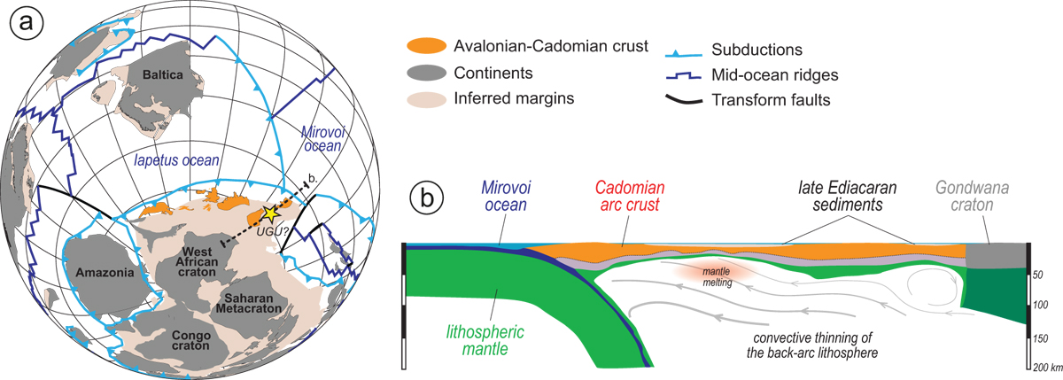
Fig. 7
Download original image
(a) Paleogeography at 545 Ma based on the full-plate model of Merdith et al. (2021), drawn using Python 3 with opensource packages pyGMT and pyGplates. The yellow star depicts the putative location of the terrains today exposed in Upper Gneiss Unit (UGU) of the eFMC. (b) Geodynamic sketch of the northern Gondwana margin at 545 Ma highlighting the context and mechanism through which the Riverie rocks formed, inspired from Erdős et al. (2022).
(a) Paléogéographie à 545 Ma basée sur le modèle de plaque de Merdith et al. (2021). L’étoile indique l’emplacement supposé des terrains correspondant aujourd’hui à l’Unité Supérieure des Gneiss. (b) Schéma géodynamique de la marge nord du Gondwana à 545 Ma, soulignant le contexte et le mécanisme par lesquels les roches de Riverie se sont formées.
Current usage metrics show cumulative count of Article Views (full-text article views including HTML views, PDF and ePub downloads, according to the available data) and Abstracts Views on Vision4Press platform.
Data correspond to usage on the plateform after 2015. The current usage metrics is available 48-96 hours after online publication and is updated daily on week days.
Initial download of the metrics may take a while.